South Asia
| South Asia | |
|---|---|
.svg.png) | |
| Countries and Territories[1] | |
| GDP (Nominal) | $2.9 trillion (April 2015)[2] |
| GDP (PPP) | $9.9 trillion (April 2015)[2] |
| Languages | Assamese, Balochi, Bengali, Dari, Dhivehi, Dzongkha, English, Gujarati, Hindi, Kannada, Kashmiri, Malayalam, Marathi, Manipuri, Nepali, Oriya, Pashto, Punjabi, Sanskrit, Sindhi, Sinhala, Tamil, Telugu, Urdu, Mizo and many others |
| Time zones | UTC+05:00, UTC+5:30, UTC+5:45, UTC+06:00 |
| Capital cities | |
| Other major cities |
List
|
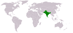
South Asia or Southern Asia is a term used to represent the southern region of the Asian continent, which comprises the sub-Himalayan countries and, for some authorities, adjoining countries to the west and east. Topographically, it is dominated by the Indian Plate, which rises above sea level as northern parts of India south of the Himalayas and the Hindu Kush. South Asia is bounded on the south by the Indian Ocean and on land (clockwise, from west) by West Asia, Central Asia, East Asia, and Southeast Asia.
The current territories of Afghanistan, Bangladesh, Bhutan, India, Maldives, Nepal, Pakistan, and Sri Lanka form the countries of South Asia, with deviating definitions based on often substantially different reasons, the British Indian Ocean Territory, Mauritius, Iran, and the Tibet Autonomous Region are included as well. South Asia is home to well over one fifth of the world's population, making it both the most populous and the most densely populated geographical region in the world.[3] The South Asian Association for Regional Cooperation is an economic cooperation organisation in the region which was established in 1985 and includes all eight nations comprising South Asia.[4]
Definitions
update.PNG)
The area of South Asia and its geographical extent is not clear cut as systemic and foreign policy orientations of its constituents are quite asymmetrical.[6] Aside from the central region of South Asia, formerly part of the British Empire, there is a high degree of variation as to which other countries are included in South Asia.[7]
The current territories of Bangladesh, India, and Pakistan, which were the core of the British Empire prior to 1947, form the central region of South Asia, while the mountain countries of Nepal and Bhutan, and island countries of Sri Lanka and Maldives are generally included. Afghanistan and Myanmar are often added, and by various deviating definitions based on often substantially different reasons, the British Indian Ocean Territory, Mauritius, Iran, and the Tibet Autonomous Region are included as well.[6][8][9][10][11][12][13][14][15]
The common concept of South Asia is largely inherited from the administrative boundaries of the British Raj,[16] with two major differences. The Aden Colony, British Somaliland and Singapore, though administered at various times under the Raj, have not been proposed as any part of South Asia.[17] The 562 princely states that were protected by but not directly ruled by the Raj became administrative parts of South Asia upon joining Union of India or Dominion of Pakistan.[18][19][20] Geopolitically, it had formed the whole territory of Greater India,[21][22]
The South Asian Association for Regional Cooperation (SAARC), a contiguous block of countries, started in 1985 with seven countries — Bangladesh, Bhutan, India, the Maldives, Nepal, Pakistan and Sri Lanka — but was extended to include Afghanistan as an eighth member in 2006.[23][24] China and Myanmar have also applied for the status of full members of SAARC.[25][26] This bloc of countries include three independent countries that were not part of the British Raj - Nepal, Bhutan and Afghanistan. The World Factbook, based on geo-politics, people, and economy defines South Asia as comprising Afghanistan, Bangladesh, Bhutan, British Indian Ocean Territory, India, Maldives, Nepal, Pakistan, and Sri Lanka.[27] The South Asia Free Trade Agreement incorporated Afghanistan in 2011, and the World Bank grouping of countries in the region also includes all eight members comprising South Asia and SAARC as well.[28][29]
When the Centre for South Asian Studies at the University of Cambridge was established, in 1964, it promoted the study of India, Pakistan, Sri Lanka, Bangladesh, the Himalayan Kingdoms (Nepal, Bhutan, and Sikkim[30]), and Burma (now Myanmar). It has since included Thailand, Malaysia, Singapore, Vietnam, Cambodia, Laos, Indonesia, the Philippines and Hong Kong.[31]
The Centres for South Asian Studies at both the University of Michigan and the University of Virginia include Tibet along with the eight members of SAARC in their research programs, but exclude the Maldives.[32][33] The South Asian Studies Program of Rutgers University and the University of California, Berkeley Centre for South Asia Studies also include the Maldives.[34][35]
The South Asian Studies Program of Brandeis University defines the region as comprising "India, Pakistan, Bangladesh, Sri Lanka, Nepal, Bhutan, and in certain contexts Afghanistan, Burma, Maldives and Tibet".[36] The similar program of Columbia University includes Afghanistan, Bangladesh, India, the Maldives, Nepal, Pakistan, and Sri Lanka in their study and excludes Burma.[37]
The United Nations Statistics Division's scheme of sub-regions include all eight members of the SAARC as part of Southern Asia, along with Iran[38] only for statistical purposes.[5] Population Information Network (POPIN) includes Afghanistan, Bangladesh, Burma, India, Nepal, Pakistan and Sri Lanka as part of South Asia. Maldives, in view of its characteristics, was admitted as a member Pacific POPIN subregional network only in principle.[39] The Hirschman–Herfindahl index of the United Nations Economic and Social Commission for Asia and the Pacific for the region includes only the original seven signatories of SAARC.[40]
The British Indian Ocean Territory is connected to the region by a publication of Jane's for security considerations.[41] The region may also include the disputed territory of Aksai Chin, which was part of the British Indian princely state of Jammu and Kashmir, but is now administered as part of the Chinese autonomous region of Xinjiang.[42]
Regional affinity of the bordering countries like Myanmar and Afghanistan is always confusing. Myanmar with its low-profile foreign policy has not drawn much scholarly attention, but Afghanistan is in a more complex situation. It was an area of vital importance for British diplomacy during the colonial era, despite the nations never falling under nominal British rule. Following India's partition, it still never lost it's importance.[6] From the time of the British withdrawal from India, there was, by and large, agreement among scholars that Afghanistan was part of South Asia, though some considered it part of Central Asia or that of Southwest Asia as well.[6] The dominant view however remained that it was part of South Asia. Thus, when Joseph B. Schwartberg edited his book in 1978 titled "An Historical Atlas of South Asia" which dealt with the cultural, political, and geographical analysis of South Asia, he included Afghanistan in his book.[6] However, drastic political changes in Afghanistan and neighbouring Western Asia starting from the late 70's made the broad consensus being questioned. During the Soviet war in Afghanistan (1979 to February 1989) it became included into Southwest Asia, and since the War on Terror (2001 onward) its included into South Asia.[6] One school of thought divides the Asian continent latitudinally and treats South and Southeast Asia as one region. The South Asia Institute (SAI) of Heidelberg University and scholars like Howard Wringgings and James Guyot subscribe to this tendency.[6]
A lack of coherent definition for South Asia has resulted in not only a lack of academic studies, but also in a lack interest for such studies.[43] The confusion exists also because of a lack of clear boundary - geographically, geopolitical, socio-culturally, economically or historically - between South Asia and other parts of Asia, especially the Middle East and Southeast Asia.[44] Identification with a South Asian identity was also found to be significantly low among respondents in a two-year survey across Bangladesh, India, Nepal, Pakistan, and Sri Lanka.[45]
Indian Subcontinent
The region was labelled variously as India (in its pre-modern sense), Greater India, Indian Subcontinent and South Asia.[21][46] "Indian Subcontinent" is a term adopted and used by the British Empire.[11][47][48][49][50][51][52][53][54] The terms "Indian subcontinent" and "South Asia" are used interchangeably.[11][47][48][50][51][52][53][54][55][56][57] According to historians Sugata Bose and Ayesha Jalal, Indian Subcontinent has come to be known as South Asia "in more recent and neutral parlance."[58] Indologist Ronald B. Inden argues that the usage of the term "South Asia" is getting more widespread since it clearly distinguishes the region from East Asia.[59] Some academics hold that the term "South Asia" is in more common use in Europe and North America, rather than the terms "Subcontinent" or the "Indian Subcontinent".[60][61]
According to anthropologist John R. Lukacs, "The Indian Subcontinent occupies the major landmass of South Asia."[62] while according to political science professor Tatu Vanhanen, "The seven countries of South Asia constitute geographically a compact region around the Indian Subcontinent".[63] According to Chris Brewster, India, Pakistan, Bangladesh, Sri Lanka, Nepal and Bhutan constitute the Indian subcontinent; with Afghanistan and Maldives included it is more commonly referred to as South Asia,[64] while according to a number of Indian scholars South Asia includes the Indian Subcontinent (India, Pakistan, Bangladesh and Nepal), as well as the island countries of Sri Lanka, Maldives and Mauritius.[65] When the term Indian subcontinent is used to mean South Asia, the island countries of Sri Lanka and the Maldives may sometimes not be included,[11] while Tibet and Nepal may either be included[66] or excluded[67] intermittently, depending on the context.
Geography

While South Asia had never been a coherent geopolitical region, it has a distinct geographical identity.[68] The region is home to a variety of geographical features, such as glaciers, rainforests, valleys, deserts, and grasslands that are typical of much larger continents. It is surrounded by three water bodies — the Bay of Bengal, the Indian Ocean and the Arabian Sea — and has acutely varied climate zones. The tip of the Indian Peninsula had the highest quality pearls.[69]
Boundary
The boundaries of South Asia vary based on how the region is defined. South Asia's northern, eastern, and western boundaries vary based on definitions used, while the Indian Ocean is the southern periphery. Most of this region rests on the Indian Plate and is isolated from the rest of Asia by mountain barriers.[70][71] Much of the region consists of a peninsula in south-central Asia, rather resembling a diamond which is delineated by the Himalayas on the north, the Hindu Kush in the west, and the Arakanese in the east,[72] and which extends southward into the Indian Ocean with the Arabian Sea to the southwest and the Bay of Bengal to the southeast.[10][73] The most common school of thought proposes the frontier between South and Southwest Asia (i.e. the Middle East) lie in eastern Iran and western Afghanistan, while the frontier between South and Central Asia in northeastern Iran, northern Afghanistan, and southern Kyrgyzstan.[74]
Indian plate

Most of this region is a subcontinent resting on the Indian Plate, the northerly portion of the Indo-Australian Plate, separated from the rest of the Eurasian Plate. The Indian Plate includes most of South Asia, forming a land mass which extends from the Himalayas into a portion of the basin under the Indian Ocean, including parts of South China and Eastern Indonesia, as well as Kunlun and Karakoram ranges,[75][76][77] and extending up to but not including Ladakh, Kohistan, the Hindu Kush range and Balochistan.[78][79][80] It may be noted that geophysically the Yarlung Tsangpo River river in Tibet is situated at the outside of the border of the Subcontinental structure, while the Pamir Mountains in Tajikistan are situated inside that border.[81]
It was once a small continent before colliding with the Eurasian Plate about 50-55 million years ago and giving birth to the Himalayan range and the Tibetan plateau. It is the peninsular region south of the Himalayas and Kuen Lun mountain ranges and east of the Indus River and the Iranian Plateau, extending southward into the Indian Ocean between the Arabian Sea (to the southwest) and the Bay of Bengal (to the southeast).
Climate

The climate of this vast region varies considerably from area to area from tropical monsoon in the south to temperate in the north. The variety is influenced by not only the altitude, but also by factors such as proximity to the sea coast and the seasonal impact of the monsoons.[82] Southern parts are mostly hot in summers and receive rain during monsoon periods. The northern belt of Indo-Gangetic plains also is hot in summer, but cooler in winter. The mountainous north is colder and receives snowfall at higher altitudes of Himalayan ranges.
As the Himalayas block the north-Asian bitter cold winds, the temperatures are considerably moderate in the plains down below. For most part, the climate of the region is called the Monsoon climate, which keeps the region humid during summer and dry during winter, and favours the cultivation of jute, tea, rice, and various vegetables in this region.
South Asia is largely divided into four broad climate zones:[83]
- The northern Indian edge and northern Pakistani uplands have a dry subtropical continental climate
- The far south of India and southwest Sri Lanka have a equatorial climate
- Most of the peninsula have a tropical climate with variations:
- Hot subtropical climate in northwest India
- Cool winter hot tropical climate in Bangladesh
- Tropical semi-arid climate in the center
- The Himalayas have an Alpine climate
Maximum relative humidity of over 80% has been recorded in Khasi and Jaintia Hills and Sri Lanka, while the area adjustment to Pakistan and western India records lower than 20%-30%.[83] Climate of South Asia is largely characterized by monsoons. South Asia depends critically on monsoon rainfall.[84] Two monsoon systems exist in the region:[85]
- The summer monsoon: Wind blows from southwest to most of parts of the region. It accounts for 70%-90% of the annual precipitation.
- The winter monsoon: Wind blows from northeast. Dominant in Sri Lanka and Maldives.
The warmest period of the year precedes the monsoon season (March to mid June). In the summer the low pressures are centered over the Indus-Gangetic Plain and high wind from the Indian Ocean blows towards the center. The monsoons are second coolest season of the year because of high humidity and cloud covering. But, at the beginning of June the jetstreams vanish above the Tibetan Plateau, low pressure over the Indus Valley deepens and the Intertropical Convergence Zone (ITCZ) moves in. The change is violent. Moderately vigorous monsoon depressions form in the Bay of Bengal and make landfall from June to September.[83]
History
Ancient era
The history of core South Asia begins with evidence of human activity of Homo sapiens, as long as 75,000 years ago, or with earlier hominids including Homo erectus from about 500,000 years ago.[86] The Indus Valley Civilization, which spread and flourished in the northwestern part of South Asia from c. 3300 to 1300 BCE in present-day Pakistan and northwest India, was the first major civilization in South Asia.[87] A sophisticated and technologically advanced urban culture developed in the Mature Harappan period, from 2600 to 1900 BCE.[88]
Classical era
This Bronze Age civilisation collapsed around the middle of the second millennium BCE. Around this time, Indo-Iranian-speaking pastoralists from Central Asia migrated to the region. They brought the Indo-Aryan languages with them and established the Iron Age Vedic Civilisation, which extended over much of the Indo-Gangetic plain and which witnessed the rise of major polities known as the Mahajanapadas. In one of these kingdoms, Magadha, Mahavira and Gautama Buddha were born in the 6th or 5th century BCE and propagated their Shramanic philosophies.
Most of South Asia was conquered by the Maurya Empire during the 4th and 3rd centuries BCE. Various parts of India ruled by numerous Middle kingdoms for the next 1,500 years, among which the Gupta Empire stands out. Southern India saw the rule of the Chalukya dynasty, Rashtrakuta dynasty, Chola empire, Western Chalukya Empire, Pallava dynasty and Pandyan Dynasty. This period, witnessing a Hindu religious and intellectual resurgence, is known as the classical or "Golden Age of India". During this period, aspects of Indian civilisation, administration, culture, and religion (Hinduism and Buddhism) spread to much of Asia, while kingdoms in southern India had maritime business links with the Roman Empire from around 77 CE.
Medieval era
Islam came as a political power in the fringe of South Asia in 8th century CE when the Arab general Muhammad bin Qasim conquered Sindh and Multan in southern Punjab in modern day Pakistan,[89] setting the stage for several successive invasions from Central Asia between the 10th and 15th centuries CE, leading to the formation of Muslim empires in South Asia such as the Delhi Sultanate and the Mughal Empire. Mughal rule came from Central Asia to cover most of the northern parts of South Asia. Mughal rulers introduced Central Asian art and architecture to India. In addition to the Mughals and various Rajput kingdoms, several independent Hindu states, such as the Vijayanagara Empire, the Maratha Empire, Eastern Ganga Empire and the Ahom Kingdom, flourished contemporaneously in southern, western, eastern and northeastern India respectively.
Modern era
The Mughal Empire suffered a gradual decline in the early 18th century, leaving a power vacuum that was exploited by local rulers such as the Sikhs and Marathas and later used by the British East India Company to gain ascendancy over most of South Asia.[90]
Beginning in the mid-18th century and over the next century, large areas of India were annexed by the British East India Company. Dissatisfaction with Company rule led to the Indian Rebellion of 1857, after which the British provinces of India were directly administered by the British Crown and witnessed a period of both rapid development of infrastructure and economic decline. During the first half of the 20th century, a nationwide struggle for independence was launched by the Indian National Congress and later joined by the Muslim League. India gained independence from the United Kingdom in 1947, after the British provinces were partitioned into the dominions of India and Pakistan and the princely states all acceded to one of the new states.
Territory and region data
2009 referenced population figures except where noted.
Core countries
With the core seven countries, the area covers about 4.48 million km² (1.7 million mi²), which is 10% of the Asian continent or 2.4% of the world's land surface area.[91][92][93] They account for about 34% of Asia's population (or over 16.5% of the world's population) and are home to a vast array of peoples.[91][92][93]
| Country | Area (km²) |
Population (2009–2012) |
Density (per km²) |
Nominal GDP(in billions of US$) (2014) |
Nominal GDP per capita (2014) |
Capital | Currency | Government | Official languages | Coat of arms |
|---|---|---|---|---|---|---|---|---|---|---|
| |
147,570 | 152,518,015[94] | 899 | $186.590 | $1,033 | Dhaka | Taka | Unitary Parliamentary Constitutional Republic | Bengali |  |
| |
38,394 | 697,000[94] | 18 | $2.086 | $2,722 | Thimphu | Ngultrum Indian rupee |
Unitary Parliamentary Constitutional Monarchy | Dzongkha |  |
| |
3,287,240 | 1,210,193,422[95] | 382[95] | $2,047.811 | $1,808 | New Delhi | Indian rupee | Federal Parliamentary Constitutional Republic | Hindi
English |
 |
| |
298 | 396,334[94] | 1,330 | $2.405 | $7,030 | Malé | Rufiyaa | Unitary Presidential Constitutional Republic | Dhivehi |  |
| |
147,181 | 26,620,080[94] | 200 | $19.637 | $699 | Kathmandu | Nepalese rupee | Federal Parliamentary Republic | Nepali | |
| |
796,095 | 180,440,000[94] | 225 | $241.411 | $1,196 | Islamabad | Pakistani rupee | Federal Parliamentary Republic | Urdu
English |
 |
| |
65,610 | 20,277,597[94] | 319 | $71.566 | $3,557 | Colombo | Sri Lankan rupee | Unitary Semi-presidential Constitutional Republic |
|
 |
Countries and territories from extended definitions
| country or region | Area (km²) |
Population (2009) |
density (per km²) |
GDP(nominal) (2009) |
GDP per capita (2011) |
Capital | Currency | Government | Official languages | Coat of Arms |
|---|---|---|---|---|---|---|---|---|---|---|
| |
652,230 | 29,150,000[96] | 52 | $34.55 billion | $621 | Kabul | Afghani | Islamic republic |  | |
| |
60 | 3,500 | 59 | N/A | N/A | Diego Garcia | US Dollar | British Overseas Territory | English | .svg.png) |
| |
676,578 | 48,137,141 | 71 | $53.140 billion | $854 | Naypyidaw | Myanma kyat | Constitutional republic | Burmese | |
| |
1,228,400 | 2,740,000 | 2 | $9.6 billion | $2,558 | Lhasa | Chinese yuan | Autonomous region of China | Tibetan, Mandarin Chinese |  |
Regional groups of countries
| Name of country/region, with flag | Area (km²) |
Population* | Population density (per km²) |
Capital or Secretariat | Currency | Countries included | Official languages | Coat of Arms |
|---|---|---|---|---|---|---|---|---|
| Core Definition (above) of South Asia | 4,482,388 | 1,596,000,000 | 400.1 | N/A | N/A | Bangladesh, Bhutan, India, Maldives, Nepal, Pakistan, Sri Lanka | N/A | N/A |
| UNSD of South Asia | 6,778,083 | 1,702,000,000 | 270.77 | N/A | N/A | Afghanistan, Bangladesh, Bhutan, India, Iran, Maldives, Nepal, Pakistan, Sri Lanka | N/A | N/A |
| SAARC | 4,637,469 | 1,626,000,000 | 350.6 | Kathmandu | N/A | Afghanistan, Bangladesh, Bhutan, India, Maldives, Nepal, Pakistan, Sri Lanka | English |
Demographics
Total population of South Asia is about 1.70 billion.[97]
Ethnic groups
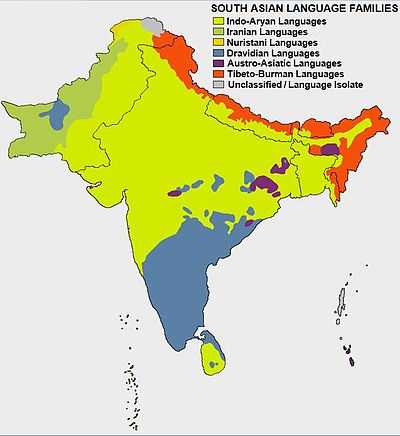
South Asia, which consists of the nations of Bangladesh, Bhutan, India, Maldives, Nepal, Pakistan, and Sri Lanka, is ethnically diverse, with more than 2,000 ethnic entities with populations ranging from hundreds of millions to small tribal groups. South Asia has been invaded and settled by many ethnic groups over the centuries - including various Dravidian, Indo-Iranian, Tibeto-Burman, and Austroasiatic groups. The amalgamation of these various groups has produced composite cultures with many common traditions and beliefs. But, the traditions of different ethnic groups in South Asia have diverged throughout earlier times, sometimes giving rise to strong local traditions such as the distinct South Indian and Bengali cultures.
Other ethnic groups, successively streaming in later mainly from Central Asia e.g. Sakas, Kushans, Huns etc. influenced pre-existing South Asian cultures. Among the last of these new arrivals were the Arabs followed by the Turks, the Afghans, and the Mughals. However, Arab influence remained relatively limited in comparison to that of the Turks, Iranians and Afghans who introduced Persianate Islamic culture to the region and contributed to the birth of Urdu, a syncretic language of combined Indo-Persian heritage,[98][99] which is widely spoken today. Ethnic Englishmen and other Britons are now practically absent after their two centuries long colonial presence, although they have left an imprint of western culture on the elite classes of India, Pakistan, Bangladesh and Sri Lanka.
Languages
The largest spoken language in this region is Hindi, its speakers numbering almost 422 million,[100] the second largest spoken language is Bengali, with about 210 million speakers.[101] Punjabi is the third most spoken language in South Asia with 130 million native speakers. Urdu is also a major language spoken in the subcontinent, especially in Pakistan, and is similar linguistically to Hindi; Hindi and Urdu together make up Hindustānī. These and several other major regional languages are part of the Indo-Aryan sub-branch of the Indo-Iranian branch of Indo-European languages - the largest linguistic group in the region. The second major language group is the Dravidian language family, consisting of the main South Indian languages like Tamil, Telugu, Kannada, and Malayalam and several smaller tribal languages such as Oraon and Gondi. The Brahui language of the Balochistan region of Pakistan and Afghanistan also belongs to the Dravidian family.
The other great sub-branch of Indo-Iranian, the Iranian languages, also have significant minority representation in South Asia, with Pashto, Dari and Balochi being widely spoken in the northwestern part of the region, in modern-day Pakistan and Afghanistan. The oldest Iranian language, Avestan, is used as a liturgical language by the Parsi-Zoroastrian community. Many Tibeto-Burman ethnic groups, who are speakers of their language-group, are found in northeast India, Tibet, Nepal, and Bhutan. Dzongkha a member of this linguistic group, is the national language of Bhutan. There are as many as 24 Tibeto-Burman languages spoken in Bhutan. Other small groups, speaking Austroasiatic languages, are also present in South Asia. English is another language which dominates South Asia, especially as a medium of advanced education and government administration.
Most of South Asia writes using various abugidas of Brāhmī origin while languages such as Urdu, Pashto, and Sindhi use derivatives of the Perso-Arabic script. Not all languages in South Asia follow this strict dichotomy though. For example, Kashmiri is written in both the Perso-Arabic script and in the Devanagari script. The same can be said for Punjabi, which is written in both Shahmukhi and Gurmukhī. Dhivehi is written in a script called Tāna that shows characteristics of both the Arabic alphabet and of an abugida.
Religions
-
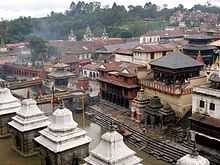
Pashupatinath Temple in Kathmandu, Nepal
-
.jpg)
Badshahi Mosque in Lahore, Pakistan
-

Ruwanwelisaya stupa in Anuradhapura, Sri Lanka
-
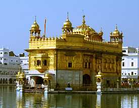
Harmandir Sahib in Amritsar, India
-
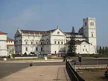
Se Cathedral in Old Goa, India
-
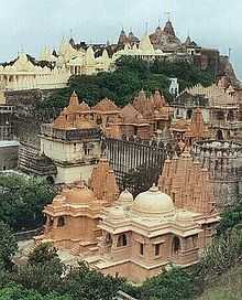
Palitana temples in Bhavnagar district, India
-
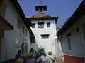
Paradesi Synagogue in Kochi, India
-

Lotus Temple in Delhi, India
-

Parsi Fire Temple in Secunderabad, India
South Asia has the largest population of Hindus in the world at 63.65% and Muslims at 33%. Taken together, South Asia as a region could be said to have the largest population of Muslims in the world. Indian religions are the religions that originated in South Asia; namely Hinduism, Jainism, Buddhism and Sikhism.[102][103] Although Indian religions are connected through the history of South Asia, they constitute a wide range of religious communities, and are not confined to the Indian subcontinent.[102]
Arabs traders brought the Abrahamic religion of Islam to South Asia, first in the present day Kerala, Sri Lanka and the Maldive Islands. Later Sindh, Balochistan, and parts of the Punjab region saw conquest by the Arab caliphates along with an influx of Muslims from further west, which resulted in spread of Islam in parts of Western region of South Asia. Subsequently, Turkic and Afghan conquerors as well as Persian Sufi missionaries furthered the spread of the Islamic religion and culture throughout the Indo-Gangetic plains, further east towards Bengal, and deep south up to the Deccan.[104]
| Afghanistan[105] | Islam (99%), Hinduism, Buddhism, Sikhism and Christianity (1%) |
| Bangladesh[106] | Islam (89.5%), Hinduism (9.5%), Buddhism (0.7%), Christianity (0.32%) |
| Bhutan[107] | Buddhism (75%), Hinduism (25%) |
| Burma[108] | Theravada Buddhism (89%), Islam (4%), Christianity (Baptist and Roman Catholic) (4%), Animism (1%), Others (including Hinduism) (2%) |
| India[107][109] | Hinduism (80.5%), Islam (13.5%), Christianity (2.3%), Sikhism (1.9%), Buddhism (0.8%), Jainism (0.4%), Others (0.6%) |
| Maldives[110] | Sunni Islam (100%) (One must be a Sunni Muslim to be a citizen on the Maldives[111][112]) |
| Nepal[113] | Hinduism (81.3%), Buddhism (9.0%), Islam (4.4%), Kirat (3.1%), Christianity (1.4%), Others (0.8%) |
| Pakistan[114] | Islam (96.28%), Hinduism (1.85%), Christianity (1.59%), Ahmaddiyya (0.22%) |
| Sri Lanka[115] | Theravada Buddhism (70.19%), Hinduism (12.61%), Islam (9.71%), Christianity (7.45%). |
Economy
India is the largest & fastest growing major economy in the region (US$2.308 trillion) and makes up almost 82% of the South Asian economy; it is the world's 7th largest in nominal terms and 3rd largest by purchasing power adjusted exchange rates(US$7.99 trillion).[116] India is the only member of powerful G-20 major economies and BRICS from the region. Pakistan has the next largest economy($245 billion) and the 5th highest GDP per capita in the region,[117] followed by Bangladesh and then by Sri Lanka which has the 2nd highest per capita and is the 4th largest economy in the region. According to a World Bank report in 2015, Driven by a strong expansion in India, coupled with favorable oil prices,From the last quarter of 2014 South Asia become the fastest-growing region in the world[118]
The Major Market stock exchanges in the region are Bombay Stock Exchange(BSE)with market Capitalization of $1.68 trillion (11th largest in the world), National Stock Exchange of India (NSE)with market capitalization of $1.64 trillion(12th largest in the world), and Karachi Stock Exchange with market capitalization of $60 billion.[119]
Health and nutrition
There are 421 million MPI-poor people in eight Indian states alone - Bihar, Chhattisgarh, Jharkhand, Madhya Pradesh, Orissa, Rajasthan, Uttar Pradesh and West Bengal - while there are 410 million in the 26 poorest African countries combined.[120] Roughly 42% of Indian children under age 5 suffer from malnutrition.[121]
According to the World Bank, 70% of the South Asian population and about 75% of South Asia's poor live in rural areas and most rely on agriculture for their livelihood.[122] According to the Global Hunger Index, South Asia has one of the highest child malnutrition rates in the world.[123] In a latest report published by UNICEF in 2008 on global hunger shows that the actual number of child deaths was around 2.1 million.[124] As of 2008 India is ranked 66th on the global hunger index.
The 2006 report stated that "the low status of women in South Asian countries and their lack of nutritional knowledge are important determinants of high prevalence of underweight children in the region". Corruption and the lack of initiative on the part of the government has been one of the major problems associated with nutrition in India. Illiteracy in villages has been found to be one of the major issues that need more government attention. The report mentioned that, although there has been a reduction in malnutrition due to the Green Revolution in South Asia, there is concern that South Asia has "inadequate feeding and caring practices for young children".[125]
Governance
India[126][127][128] and Pakistan[129][130] are the dominant political powers in the region. India is by far the largest country in the area covering around three-fourths the land area of the subcontinent. India has the largest population of around three times the combined population of the 6 other countries in the subcontinent.[131] India is also the world's largest democracy[132] India's annual defence budget for 2013-14 is $39.2 Billion[133] which is equal to the whole Pakistan's Federal budget of $39.3 billion for 2014-15.[134]
Bangladesh is a unitary state and parliamentary democracy.[135] Bangladesh also stands out as one of the few Muslim-majority democracies. “It is a moderate and generally secular and tolerant — though sometimes this is getting stretched at the moment — alternative to violent extremism in a very troubled part of the world,” said Dan Mozena, the U.S. ambassador to Bangladesh. Although Bangladesh’s legal code is secular, more citizens are embracing a conservative version of Islam, with some pushing for sharia law, analysts say. Experts say that the rise in conservatism reflects the influence of foreign-financed Islamic charities and the more austere version of Islam brought home by migrant workers in Persian Gulf countries.[136]
Diplomacy among the countries of South Asia has been mainly driven by populist politics, with the centre-stage taken by India-Pakistan conflict ever since their independence in 1947, and then the creation of Bangladesh under tense circumstances in 1971. During the height of Cold war, the elite political leaders of Pakistan aligned with the US, while India played crucial role in forming the Non-Aligned Movement and while maintaining goodwill relations with the USSR.
Pakistan's governance is one of the most conflicted in the region. The military rule and the unstable government in Pakistan has become a concern for the South Asian region. In Nepal, the governance has struggled to come in the side of democracy and it only showed signs in the recent past, basically in the 21st century, to support the democratic system. The political situation in Sri Lanka has been dominated by an increasingly assertive Sinhalese nationalism, and the emergence of a Tamil separatist movement under LTTE, which was suppressed in May 2009. Burma's politics is dominated by a military Junta, which has sidelined the democratic forces led by Aung San Suu Kyi.
| Bangladesh | Bhutan | India | Maldives | Nepal | Pakistan | Sri Lanka | ||
|---|---|---|---|---|---|---|---|---|
| Inequality-adjusted Human Development Index (2012)[137] (global ranking of 202) | 146 | 140 | 136 | 104 | 157 | 146 | 92 | |
| Corruption Perception Index (2014)[138] (global ranking of 175) | 136 | 31 | 94 | N/A | 116 | 127 | 91 | |
| The Worldwide Governance Indicators (2012)[139] | Government Effectiveness (percentile rank) | 22.49 | 67.46 | 47.37 | 48.33 | 16.75 | 23.44 | 45.93 |
| Rule of law (percentile rank) | 19.43 | 59.24 | 52.61 | 38.39 | 26.54 | 18.96 | 52.13 | |
| Political stability and absence of violence/terrorism (percentile rank) | 9 | 72.51 | 11.85 | 86.97 | 8.53 | 0.95 | 22.75 | |
| Voice and accountability (percentile rank) | 34.12 | 38.86 | 58.29 | 32.23 | 27.96 | 23.70 | 29.86 | |
| Multidimensional Poverty Index (2013):[140] (global ranking of 114) | 88 | 67 | 85 | 42 | 80 | 82 | 45 | |
Culture and Heritage
The four South Indian states and northern parts of Sri Lanka share a Dravidian culture, due to the prominence of Dravidian languages there. Pakistan is split with its two western regions of Baluchistan and Khyber Pakhtunkhwa sharing a greater Iranian heritage and its two eastern provinces of Sindh and Punjab sharing a more Indo-Aryan culture. Bangladesh and the state of West Bengal share a common heritage and culture based on the Bengali language.
Nepal, Bhutan, the states of Sikkim, Arunachal Pradesh, Ladakh in the state of Jammu and Kashmir and parts of the states of Himachal Pradesh, Uttarakhand have a great cultural similarity to Tibet, Tibetan Buddhism being the dominant religion there. Finally the border states of Assam, Meghalaya, Mizoram, Manipur, Nagaland and Tripura have cultural affinities with South East Asia.
See also
- Indian subcontinent
- South Asian cuisine
- South Asia Disaster Report
- Genetics and archaeogenetics of South Asia
- List of tallest buildings and structures in South Asia
References
- ↑ "The World Factbook: South Asia". Retrieved 2 March 2015.
- ↑ 2.0 2.1 IMF
- ↑
- ↑ SAARC Summit. "SAARC". SAARC Summit. Retrieved 17 December 2013.
- ↑ 5.0 5.1 "Standard Country or Area Codes for Statistical Use". Millenniumindicators.un.org. Retrieved 2012-08-25.
- ↑ 6.0 6.1 6.2 6.3 6.4 6.5 6.6 Partha Sarathy Ghosh, Cooperation and Conflict in South Asia, page 4-5, Technical Publications, 1989, ISBN 9788185054681
- ↑ Bertram Hughes Farmer, An Introduction to South Asia, pages 1, Routledge, 1993, ISBN 0-415-05695-0
- ↑ Arthur Berriedale Keith, A Constitutional History of India: 1600-1935, pages 440-444, Methuen & Co, 1936
- ↑ N.D. Arora, Political Science for Civil Services Main Examination, page 42:1, Tata McGraw-Hill Education, 2010, 9780070090941
- ↑ 10.0 10.1 "Indian subcontinent". New Oxford Dictionary of English (ISBN 0-19-860441-6) New York: Oxford University Press, 2001; p. 929: "the part of Asia south of the Himalayas which forms a peninsula extending into the Indian Ocean, between the Arabian Sea and the Bay of Bengal
- ↑ 11.0 11.1 11.2 11.3 John McLeod, The history of India, page 1, Greenwood Publishing Group, 2002, ISBN 0-313-31459-4
- ↑ Stephen Adolphe Wurm, Peter Mühlhäusler & Darrell T. Tryon, Atlas of languages of intercultural communication in the Pacific, Asia, and the Americas, pages 787, International Council for Philosophy and Humanistic Studies, Published by Walter de Gruyter, 1996, ISBN 3-11-013417-9
- ↑ "Indian subcontinent" > Geology and Geography.
- ↑ The Columbia Electronic Encyclopedia, 6th ed. Columbia University Press, 2003: "region, S central Asia, comprising the countries of Pakistan, India, and Bangladesh and the Himalayan states of Nepal, and Bhutan. Sri Lanka, an island off the southeastern tip of the Indian peninsula, is often considered a part of the subcontinent."
- ↑ Haggett, Peter (2001). Encyclopedia of World Geography (Vol. 1). Marshall Cavendish. p. 2710. ISBN 0-7614-7289-4.
- ↑ Navnita Chadha Behera, International Relations in South Asia: Search for an Alternative Paradigm, page 129, SAGE Publications India, 2008, ISBN 9788178298702
- ↑ United Nations, Yearbook of the United Nations, pages 297, Office of Public Information, 1947, United Nations
- ↑ Encyclopædia Britannica: A New Survey of Universal Knowledge (volume 4), pages 177, Encyclopædia Britannica Inc., 1947
- ↑ Ian Copland, The Princes of pre-India in the Endgame of the British Empire: 1917-1947, pages 263, Cambridge University Press, 2002, ISBN 0-521-89436-0
- ↑ Ben Cahoon. "Pakistan Princely States". Worldstatesmen.org. Retrieved 2010-08-23.
- ↑ 21.0 21.1 Kathleen M. Baker and Graham P. Chapman, The Changing Geography of Asia, page 10, Routledge, 2002, ISBN 9781134933846
- ↑ Sushil Mittal and Gene Thursby, Religions of South Asia: An Introduction, page 3, Routledge, 2006, ISBN 9781134593224
- ↑ Sarkar, Sudeshna (16 May 2007). "SAARC: Afghanistan comes in from the cold". Current Affairs - Security Watch. Swiss Federal Institute of Technology, Zürich. Retrieved 6 April 2011.
- ↑ "South Asian Organisation for Regional Cooperation (official website)". SAARC Secretariat, Kathmandu, Nepal. Retrieved 6 April 2011.
- ↑ Chatterjee Aneek, International Relations Today: Concepts and Applications, page 166, Pearson Education India, ISBN 9788131733752
- ↑ "SAARC Membership: India blocks China's entry for the time being". Retrieved 17 March 2015.
- ↑ "South Asia". Retrieved 20 March 2015.
- ↑ South Asia: Data, Projects and Research, The World Bank
- ↑ "SAFTA Protocol". Retrieved 20 March 2015.
- ↑ Grolier Incorporated, The Encyclopedia Americana (volume 14), pages 201, Grolier, 1988, ISBN 0-7172-0119-8
- ↑ About Us, Centre for South Asian Studies, University of Cambridge
- ↑ CSAS, Centre for South Asian Studies, University of Michigan
- ↑ About Us, Centre for South Asian Studies, University of Virginia
- ↑ South Asian Studies Program, Rutgers University
- ↑ "Center for South Asia Studies: University of California, Berkeley". Southasia.berkeley.edu. Retrieved 2012-08-19.
- ↑ South Asian Studies, Brandeis University
- ↑ South Asia Institute, Columbia University
- ↑ Geographical region and composition, Composition of macro geographical (continental) regions, geographical sub-regions, and selected economic and other groupings, United Nations
- ↑ Asia-Pacific POPIN Consultative Workshop Report, Asia-Pacific POPIN Bulletin, Vol. 7, No. 2 (1995), pages 7-11
- ↑ Mapping and Analysis of Agricultural Trade Liberalization in South Asia, Trade and Investment Division (TID), United Nations Economic and Social Commission for Asia and the Pacific
- ↑ Territories (British Indian Ocean Territory), Jane's Information Group
- ↑ Dale Hoiberg and Indu Ramchandani, Students' Britannica India (vol. 1), page 45, Popular Prakashan, 2000, ISBN 978-0-85229-760-5
- ↑ Vernon Marston Hewitt, The international politics of South Asia, page xi, Manchester University Press, 1992, ISBN 0-7190-3392-6
- ↑ Dallen J. Timothy and Gyan P. Nyaupane, Cultural Heritage and Tourism in the Developing World: A Regional Perspective, page 127, Routledge, 2009, ISBN 9781134002283
- ↑ Kishore C. Dash, Regionalism in South Asia, pages 172-175, Routledge, 2008, ISBN 0-415-43117-4
- ↑ Sushil Mittal and Gene Thursby, Religions of South Asia: An Introduction, page 3, Routledge, 2006, ISBN 9781134593224
- ↑ 47.0 47.1 Milton Walter Meyer, South Asia: A Short History of the Subcontinent, pages 1, Adams Littlefield, 1976, ISBN 0-8226-0034-X
- ↑ 48.0 48.1 Jim Norwine & Alfonso González, The Third World: states of mind and being, pages 209, Taylor & Francis, 1988, ISBN 0-04-910121-8
- ↑ Boniface, Brian G.; Christopher P. Cooper (2005). Worldwide destinations: the geography of travel and tourism. Butterworth-Heinemann. ISBN 978-0-7506-5997-0.
- ↑ 50.0 50.1 Judith Schott & Alix Henley, Culture, Religion, and Childbearing in a Multiracial Society, pages 274, Elsevier Health Sciences, 1996, ISBN 0-7506-2050-1
- ↑ 51.0 51.1 Raj S. Bhopal, Ethnicity, race, and health in multicultural societies, pages 33, Oxford University Press, 2007, ISBN 0-19-856817-7
- ↑ 52.0 52.1 Lucian W. Pye & Mary W. Pye, Asian Power and Politics, pages 133, Harvard University Press, 1985, ISBN 0-674-04979-9
- ↑ 53.0 53.1 Mark Juergensmeyer, The Oxford handbook of global religions, pages 465, Oxford University Press US, 2006, ISBN 0-19-513798-1
- ↑ 54.0 54.1 Sugata Bose & Ayesha Jalal, Modern South Asia, pages 3, Routledge, 2004, ISBN 0-415-30787-2
- ↑ Boniface, Brian G.; Christopher P. Cooper (2005). Worldwide destinations: the geography of travel and tourism. Butterworth-Heinemann. ISBN 978-0-7506-5997-0.
- ↑ Shiv R. Jhawar, Building a Noble World, page 39, Noble World Foundation, 2004, ISBN 9780974919706
- ↑ Erika Lee and Judy Yung, Angel Island: Immigrant Gateway to America, page xxiii, Oxford University Press, 2010, ISBN 9780199752799
- ↑ Sugata Bose & Ayesha Jalal, Modern South Asia, pages 3, Routledge, 2004, ISBN 0415307872
- ↑ Ronald B. Inden, Imagining India, page 51, C. Hurst & Co. Publishers, 2000, ISBN 1850655200
- ↑ Judith Schott & Alix Henley, Culture, Religion, and Childbearing in a Multiracial Society, pages 274, Elsevier Health Sciences, 1996, ISBN 0750620501
- ↑ Raj S. Bhopal, Ethnicity, race, and health in multicultural societies, pages 33, Oxford University Press, 2007, ISBN 0198568177
- ↑ John R. Lukacs, The People of South Asia: the biological anthropology of India, Pakistan, and Nepal, page 59, Plenum Press, 1984, ISBN 9780306414077
- ↑ Tatu Vanhanen, Prospects of Democracy: A Study of 172 Countries, page 144, Routledge, 1997, ISBN 9780415144063
- ↑ Chris Brewster and Wolfgang Mayrhofe, Handbook of Research on Comparative Human Resource Management, page 576, Edward Elgar Publishing, 2012, ISBN 9780857938718
- ↑ Peter D. Tyson, Global-Regional Linkages in the Earth System, page 75, Springer, 2002, ISBN 9783540424031
- ↑ Harle, James C. (1994). The art and architecture of the Indian subcontinent. Yale University Press. p. 214. ISBN 0-300-06217-6.
- ↑ Hackin, Joseph; Couchoud, Paul Louis (1996). The Mythologies of the East: Indian Subcontinent, Middle East, Nepal and Tibet, Indo-China and Java. Aryan Books International. p. 1. ISBN 81-7305-018-X.
- ↑ Saul Bernard Cohen, Geopolitics of the world system, pages 304, Rowman & Littlefield, 2003, ISBN 0-8476-9907-2
- ↑ Xinru, Liu, "The Silk Road in World History" (New York: Oxford University Press, 2010), 40.
- ↑ "Asia" > Geology and Geography. The Columbia Electronic Encyclopedia, 6th ed. Columbia University Press, 2003: "Asia can be divided into six regions, each possessing distinctive physical, cultural, economic, and political characteristics... South Asia (Afghanistan and the nations of the Indian subcontinent) is isolated from the rest of Asia by great mountain barriers."
- ↑ "Asia" > Geologic history - Tectonic framework. Encyclopædia Britannica. Encyclopædia Britannica Online, 2009: "The paleotectonic evolution of Asia terminated some 50 million years ago as a result of the collision of the Indian subcontinent with Eurasia. Asia’s subsequent neotectonic development has largely disrupted the continent’s preexisting fabric. The first-order neotectonic units of Asia are Stable Asia, the Arabian and Indian cratons, the Alpide plate boundary zone (along which the Arabian and Indian platforms have collided with the Eurasian continental plate), and the island arcs and marginal basins."
- ↑ Chapman, Graham P. & Baker, Kathleen M., eds. The changing geography of Asia. (ISBN 0-203-03862-2) New York: Taylor & Francis e-Library, 2002; p. 10: "This greater India is well defined in terms of topography; it is the Indian sub-continent, hemmed in by the Himalayas on the north, the Hindu Khush in the west and the Arakanese in the east."
- ↑ The history of India - By John McLeod. Books.google.com. Retrieved 2012-03-27.
- ↑ Mehdi Parvizi Amineh, TheGreater Middle East in Global Politics, page 112, BRILL, 2007, ISBN 9789004158597
- ↑ Sinvhal, Understanding Earthquake Disasters, page 52, Tata McGraw-Hill Education, 2010, ISBN 978-0-07-014456-9
- ↑ Harsh K. Gupta, Disaster management, page 85, Universities Press, 2003, ISBN 978-81-7371-456-6
- ↑ James R. Heirtzler, Indian ocean geology and biostratigraphy, page American Geophysical Union, 1977, ISBN 978-0-87590-208-1
- ↑ M. Asif Khan, Tectonics of the Nanga Parbat syntaxis and the Western Himalaya, page 375, Geological Society of London, 2000, ISBN 978-1-86239-061-4
- ↑ Srikrishna Prapnnachari, Concepts in Frame Design, page 152, Srikrishna Prapnnachari, ISBN 978-99929-52-21-4
- ↑ A. M. Celâl Şengör, Tectonic evolution of the Tethyan Region, Springer, 1989, ISBN 978-0-7923-0067-0
- ↑ Valentin Semenovich Burtman & Peter Hale Molnar, Geological and Geophysical Evidence for Deep Subduction of Continental Crust Beneath the Pamir, pages 10, Geological Society of America, 1993, ISBN 0-8137-2281-0
- ↑ Anita M. Weiss and Muhammad Aurang Zeb Mughal (2012). 'Pakistan'. Kotzé, Louis and Morse, Stephen (eds), Berkshire Encyclopedia of Sustainability, Vol. 9. Great Barrington, Mass.: Berkshire, pp. 236-240.
- ↑ 83.0 83.1 83.2 John E. Olive, The Encyclopedia of World Climatology, page 115-117, Springer, 2005, ISBN 9781402032646
- ↑ Peter D. Tyson, Global-Regional Linkages in the Earth System, page 83, Springer, 2002, ISBN 9783540424031
- ↑ Peter D. Tyson, Global-Regional Linkages in the Earth System, page 76, Springer, 2002, ISBN 9783540424031
- ↑ G. Bongard-Levin, A History of India (Progress Publishers: Moscow, 1979) p. 11.
- ↑ Romila Thapar, A History of India (Penguin Books: New York, 1966) p. 23.
- ↑ Romila Thapar, A History of India, p. 24.
- ↑ "History in Chronological Order". Government of Pakistan. Retrieved 2008-01-09.
- ↑ "Pakistan". Library of Congress. Retrieved 2008-01-09.
- ↑ 91.0 91.1 Desai, Praful B. 2002. Cancer control efforts in the Indian subcontinent. Japanese Journal of Clinical Oncology. 32 (Supplement 1): S13-S16. "The Indian subcontinent in South Asia occupies 2.4% of the world land mass and is home to 16.5% of the world population...."
- ↑ 92.0 92.1 "Asia" > Overview. Encyclopædia Britannica. Encyclopædia Britannica Online, 2009: "The Indian subcontinent is home to a vast diversity of peoples, most of whom speak languages from the Indo-Aryan subgroup of the Indo-European family."
- ↑ 93.0 93.1 "Indian Subcontinent". Encyclopedia of Modern Asia. Macmillan Reference USA (Gale Group), 2006: "The area is divided between five major nation-states, Bangladesh, India, Nepal, Pakistan, and Sri Lanka, and includes as well the two small nations of Bhutan and the Maldives Republic... The total area can be estimated at 4.4 million square kilometres, or exactly 10 percent of the land surface of Asia.... In 2000, the total population was about 22 percent of the world's population and 34 percent of the population of Asia."
- ↑ 94.0 94.1 94.2 94.3 94.4 94.5 USCensusBureau:Countries ranked by population, 2012
- ↑ 95.0 95.1 "Census of India : Provisional Population Totals : India :Census 2011". Censusindia.gov.in. Retrieved 2012-03-21.
- ↑ Department of Economic and Social Affairs Population Division (2009). "World Population Prospects, Table A.1" (PDF). 2008 revision. United Nations. Retrieved 2009-03-12.
- ↑ "SAARC needs to boost volume of trade". Saarc-sic.org. Retrieved 2012-11-08.
- ↑ Linguistic Syncretism and Language Ideologies
- ↑ Urdu Literary Culture: The Syncretic Tradition
- ↑ "Census of India - Statement 1". Censusindia.gov.in. Retrieved 2010-08-23.
- ↑ "Languages Spoken by More Than 10 Million People". MSN Encarta. Retrieved 2009-06-27.
- ↑ 102.0 102.1 Adams, C. J., Classification of religions: Geographical, Encyclopædia Britannica, 2007. Accessed: 15 July 2010
- ↑ Adams: "Indian religions, including early Buddhism, Hinduism, Jainism, and Sikhism, and sometimes also Theravāda Buddhism and the Hindu- and Buddhist-inspired religions of South and Southeast Asia".
- ↑ Alberts, Irving, T., . D. R. M. (2013). Intercultural Exchange in Southeast Asia: History and Society in the Early Modern World (International Library of Historical Studies). I.B. Tauris.
- ↑ "CIA - The World Factbook - Afghanistan". Cia.gov. Retrieved 2012-03-27.
- ↑ "Bangladesh : AT A GLANCE". Banbeis.gov.bd. Retrieved 2010-08-23.
- ↑ 107.0 107.1 "CIA - The World Factbook". Cia.gov. Retrieved 2012-03-27.
- ↑ "CIA - The World Factbook - Burma". Cia.gov. Retrieved 2012-03-27.
- ↑ "Indian Census". Censusindia.gov.in. Retrieved 2010-08-23.
- ↑ "religion". Maldives. Retrieved 2010-08-23.
- ↑ "Maldives". Law.emory.edu. 1920-02-21. Retrieved 2010-08-23.
- ↑ Maldives - Religion, countrystudies.us
- ↑ "NEPAL" (PDF). Retrieved 2010-08-23.
- ↑ Population by religions, Statistics Division of the Government of Pakistan
- ↑ "Table 1". Web.archive.org. 2007-05-13. Archived from the original on 2007-05-13. Retrieved 2010-08-23.
- ↑ IMF
- ↑ "Welcome to WorldBank Group". Web.worldbank.org. Retrieved 2010-08-23.
- ↑ World Bank
- ↑
- ↑ "India far poorer than Africa, new measure shows". Theaustralian.com.au. 2012-02-17. Retrieved 2012-03-27.
- ↑ Yardley, Jim (2012-01-10). "Malnutrition in India Is Widespread, Report Finds". The New York Times.
- ↑ "Agriculture in South Asia". World Bank.
- ↑ "2008 Global Hunger Index Key Findings & Facts". 2008.
- ↑ "Child mortality rate highest in India: UNICEF - Health News - IBNLive". Ibnlive.in.com. 2010-02-03. Retrieved 2010-08-23.
- ↑ Pandey, Geeta (2006-10-13). "'Hunger critical' in South Asia". BBC. Retrieved 2010-01-04.
- ↑ "The Eu’S External Relations". Europarl.europa.eu. Retrieved 2010-08-23.
- ↑ http://www.theindianrepublic.com/tbp/foreign-policy-seizing-initiative-maintaining-momentum-100037338.html
- ↑ http://m.niticentral.com/2014/05/23/why-invitation-to-saarc-countries-is-modis-master-stroke-226470.html
- ↑ Barry Buzan (2004). The United States and the great powers: world politics in the twenty-first century. Polity. pp. 71, 99. ISBN 978-0-7456-3374-9. Retrieved 27 December 2011.
- ↑ Hussein Solomon. "South African Foreign Policy and Middle Power Leadership". Retrieved 27 December 2011.
- ↑ "Area and Population of Countries (mid-2006 estimates)". Infoplease. Retrieved 2010-08-23.
- ↑ http://www.bbc.co.uk/learningzone/clips/india-worlds-largest-democracy/10104.html
- ↑ http://m.economictimes.com/news/politics-and-nation/indias-defence-budget-is-one-third-of-china-pentagon/articleshow/36129618.cms
- ↑ http://www.dawn.com/news/1110324/federal-cabinet-approves-budget-2014-15
- ↑ "The world factbook-Bangladesh". The CIA.
- ↑ Gowen, Annie. "Bangladesh’s political unrest threatens economic gains, democracy". Washington Post. Retrieved 6 June 2014.
- ↑ Inequality-adjusted Human Development Index (2012), UNDP
- ↑ Corruption Perception Index (2014), Transparency International
- ↑ The Worldwide Governance Indicators (2012), World Bank
- ↑ Multidimensional Poverty Index (2013), Oxford University
External links
| Wikimedia Commons has media related to South Asia. |
- World Bank, South Asia Region
- BBC South Asia
- Birding in South Asia
- South Asian Awareness Network Conference Website
- Digital South Asia Library
- Poverty and Economics in South Asia: Cooperation and Integration
| ||||||||||
| ||||||||||||||
| ||||||||||||||||||||||||||||||||||||||||||||||||||||||||||||||||||||||