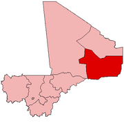
Sony Aliber
| Sony Aliber | |
|---|---|
| Commune | |
 Forgho Sonrai Location in Mali | |
| Coordinates: 16°30′25″N 0°4′28″W / 16.50694°N 0.07444°WCoordinates: 16°30′25″N 0°4′28″W / 16.50694°N 0.07444°W | |
| Country |
|
| Region | Gao Region |
| Cercle | Gao Cercle |
| Area[1] | |
| • Total | 982.9 km2 (379.5 sq mi) |
| Population (2009)[2] | |
| • Total | 44,099 |
| • Density | 45/km2 (120/sq mi) |
| Time zone | GMT (UTC+0) |
Sony Aliber or Soni Ali Ber is a commune in the Cercle of Gao in the Gao Region of south-eastern Mali. The main villages are: Bagnadji, Batal, Berrah, Forgho Arma, Forgho Songhai, Kochakarey, Kokorom, Magnadoué, Seina and Zindiga.[1] The administrative center (Chef-lieu) is the village of Forgo Sourhai which is located 25 km north of Gao.[3] The commune includes the banks of the River Niger for a distance of around 35 km. In the 2009 census the commune had a population of 44,099.
References
- ↑ 1.0 1.1 Schéma Directeur de Lutte Contre L’ensablement dans le Nord Du Mali (6ème Et 7ème Régions): Monographie de la Commune de Soni Ali Ber (in French), Ministère de l’Environnement et de L’assainissement, République du Mali, 2004
- ↑ Resultats Provisoires RGPH 2009 (Région de Gao) (in French), République de Mali: Institut National de la Statistique
- ↑ Plan de Securite Alimentaire Commune Rurale de Soni Ali Ber 2005-2009 (in French), Commissariat à la Sécurité Alimentaire, République du Mali, USAID-Mali, 2005.
| |||||||||||||||||||||||||
