Solihull
| Solihull | |
 Solihull High Street |
|
 Solihull |
|
| Population | 206,700 (2011 Census) |
|---|---|
| OS grid reference | SP1579 |
| – London | 113 mi (182 km) |
| Metropolitan borough | Solihull |
| Metropolitan county | West Midlands |
| Region | West Midlands |
| Country | England |
| Sovereign state | United Kingdom |
| Post town | SOLIHULL |
| Postcode district | B36, B37, B40, B90, B91, B92, B93, B95 |
| Dialling code | 0121 |
| Police | West Midlands |
| Fire | West Midlands |
| Ambulance | West Midlands |
| EU Parliament | West Midlands |
| UK Parliament | Solihull |
|
|
Coordinates: 52°24′47″N 1°46′41″W / 52.413°N 1.778°W
Solihull (/ˈsɒlɨhʌl/ or /ˈsoʊliːhʌl/ or /soʊliˈhʌl/) is a town in the West Midlands of England with a population of 94,753.[1] It is a part of the West Midlands conurbation and is located 9 miles (14.5 km) southeast of Birmingham city centre. It is the largest town in, and administrative centre of, the larger Metropolitan Borough of Solihull, which itself has a population of 200,400.
Historically part of Warwickshire, Solihull is one of the most prosperous towns in the English Midlands.[2] In November 2013, the uSwitch Quality of Life Index named Solihull the "best place to live" in the United Kingdom.[3][4] Residents of Solihull and those born in the town are referred to as Silhillians. The motto of Solihull is Urbs in Rure (Town in Country).
History
Toponymy
Solihull's name is commonly thought to have derived from the position of its parish church, St Alphege, on a 'soily' hill.[5] The church was built on a hill of stiff red marl, which turned to sticky mud in wet weather.
Early history
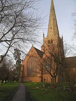
Solihull probably came into being about a thousand years ago, as a clearing in the forest to which people would come to trade. The town is noted for its historic architecture, which includes surviving examples of timber framed Tudor style houses and shops. The historic Solihull School dates from 1560 (although not on its present site). The red sandstone parish church of St. Alphege dates from a similar period and is a large and handsome example of English Gothic church architecture, with a traditional spire 168 feet (51 metres) high, making it visible from a great distance. It is located at the head of High Street and is a Grade I listed building.[6] It was founded in about 1220 by Hugh de Oddingsell. A chantry chapel was also founded there by Sir William de Oddingsell in 1277 and the upper chapel in St Alphege was built for a chantry.
20th century
Unlike nearby Birmingham, the Industrial Revolution largely passed Solihull by and until the 20th century Solihull remained a small market town. World War II also nearly passed Solihull by. Neighbouring Coventry and Birmingham were severely damaged by repeated German bombing raids but apart from some attacks on what is now the Land Rover plant, the airport and the local railway lines, Solihull escaped largely intact.
In 1901, the population of the town was just 7,500. However, by the 1960s, the population had grown to over 100,000. This growth was due to a number of factors including a large slum clearance programme in Birmingham, the development of the Rover car plant, the expansion of what was then Elmdon Airport into Birmingham International Airport and, perhaps most significantly, the release of large tracts of land for housing development attracting inward migration of new residents from across the UK.
Until the early 1960s, the main high street remained much as it would have been in the late 19th century with several streets of Victorian terraced houses linking High Street with Warwick Road. The construction of the central shopping area known as Mell Square (named after W. Maurice Mell, the town clerk who planned the work) involved the demolition of properties in Mill Lane and Drury Lane, some of which were several hundred years old, together with that of the large Victorian Congregational Church that had stood on the corner of Union Street and Warwick Road. On the right along High Street from St Alphege's Church porch is one of the town's oldest landmarks, the George, which dates from the 16th century. It is now called the Ramada Jarvis Hotel.
Arden Golf Club, Solihull, (now defunct) was founded in 1891. The course was still appearing on maps into the 1930s.[7]
Governance
Due to its growth, Solihull was promoted from an urban district to a municipal borough, the honour being bestowed by Princess Margaret.[8]
In 1964, Solihull became a county borough and on this occasion the Queen bestowed the honour. In 1974, the Solihull county borough was merged with the rural district surrounding Meriden to form the Metropolitan Borough of Solihull. This also includes the districts known as Shirley, Knowle, Dorridge, Balsall Common, Castle Bromwich and Chelmsley Wood. At this time it also moved from the county of Warwickshire to the West Midlands.
The member of parliament for Solihull is Lorely Burt, who won her seat in 2005.
Wards
There are 17 wards in Solihull;[9] Shirley West, Blythe, Shirley South, Meriden, Elmdon, Lyndon, Smith's Wood, Chelmsley Wood, Dorridge & Hockley Heath, Olton, St. Alphege, Shirley East, Silhill, Kingshurst & Fordbridge, Castle Bromwich, Knowle and Bickenhill.[10] Each ward is represented by three councillors at Solihull Metropolitan Borough Council, making a total of 51 councillors.[9] The mayor is elected by the Council and is currently (2013–14) Joe Tildesley of the Conservative Party.
Education
Solihull has no university, but there are five universities within 16 miles of the town; three in Birmingham and two in Coventry. However, Solihull College, formerly known as the Solihull College of Technology, offers several foundation degree and full degree courses, particularly in technical subject areas such as computer sciences and engineering. It has not applied to attain university college or university status.
There is also a sixth form college located on the outskirts of the town centre. This is known as the Sixth Form College, Solihull and is where students, mainly between the ages of sixteen and eighteen, complete their secondary education.
Solihull School is an independent school and is located on Warwick Road near the centre of the town. It was founded in 1560 and celebrated its 450th anniversary in 2010.
Solihull had a 'Wave 1' proposal of the Building Schools for the Future investment programme approved. They were awarded over £80 million to transform six schools in the north of the borough in December 2004. As a result of the funding, there will be six new schools constructed within seven years. The school curriculum will be redesigned as well as a further £6 million investment in managed ICT services. The six schools to be rebuilt are Park Hall, Smith's Wood, Archbishop Grimshaw, Lanchester Special School and Forest Oak and Merstone special schools. Forest Oak and Merstone have been already rebuilt on one site. Lanchester, Park Hall and Smith's Wood have been built by BAM PPP, under 'Private Finance Initiative'. Archbishop Grimshaw has been built by BAM PPP under a traditional contract.[11]
Transport


A number of main roads pass through Solihull including the A41 Birmingham to Warwick road and the A34 Birmingham to Stratford road. The M42 and the M40 both pass through Solihull and provide very rapid links to Oxford and London and to the rest of the motorway network surrounding the West Midlands. Birmingham International Airport (BHX) is located in Solihull.
Solihull railway station is on the former Great Western Railway line from Birmingham Snow Hill station to London Paddington although trains now run along the Chiltern Main Line terminating at London Marylebone. Solihull railway station was first built on a very grand scale, with 2 island platforms complete with nearly full length canopies, and a large goods yard, boasting space for some 200+ waggons; the yard was equipped with a loading dock, goods shed and large crane. Solihull was also rare in being only one of a handful of stations in the area to have a goods relief line.
Other railway links are provided on the West Coast Main Line, as Birmingham International railway station lies within the borough's boundaries and offers frequent express connections to London. Express train services through Solihull are now run by Chiltern Railways and local services by London Midland.
The Grand Union Canal passes across Solihull, coming within a mile of the town centre and linking the town to the River Thames in London.
Local bus services are provided largely by National Express West Midlands from their Yardley Wood and Acocks Green depots in south and southeast Birmingham respectively.
Economy
Solihull offers a variety of shopping facilities. It has an open-air 1960s-style shopping centre called Mell Square which was constructed following the demolition of several terraces of Victorian houses and the original Solihull Congregational Church. In recent years, the town has undergone much development, and High Street has been pedestrianised since 1994. On 2 July 2002, a large new shopping centre, Touchwood, was opened by the Queen.
Solihull is the home of the four-wheel-drive car manufacturer Land Rover's main production plant (situated east of the Lode Heath district) and a range of other major companies. The village of Meriden was the famous home of the Triumph motorbike factory from 1942-1983. The former home of retail bakers Three Cooks, after it was brought out of administration in 2006, the new company Cooks the Bakery retains its HQ in Solihull. Other major companies headquartered in Solihull include pub company Enterprise Inns and mortgage and personal loan provider Paragon.
The National Exhibition Centre is within the borough of Solihull, as is almost all of Birmingham Airport and the ever-expanding Birmingham Business Park.
Communal facilities
Parks and local nature reserves

Solihull has a number of parks and local nature reserves, including for:
- Alcott Wood in Moorend Avenue, Chelmsley Wood; 5.7 hectares (14 acres) of semi natural ancient woodland, designated in 2002.[12]
- Babbs Mill in Fordbridge Road, Kingshurst; 24 hectares (59 acres) of mixed grassland, lake and woodland habitats, designated in 2000.[12]
- Bills Wood, in Bill's Lane, Shirley; 7 hectares (17 acres) of semi natural ancient woodland, designated in 1991.[12]
- Dorridge Wood, in Arden Road, Dorridge; 7.5 hectares (19 acres) of semi natural woodland, designated in 2000.[12]
- Elmdon Park, at Elmdon Manor, Solihull; 4.6 hectares (11 acres) of former walled garden, managed by Warwickshire Wildlife Trust, designated in 1995.[12]
- Jobs Close in Longdon Road, Knowle; 3.5 hectares (8.6 acres) of grassland and woodland with pond, designated in 2004.[12]
- Palmers Rough, in Jacey Road, Shirley; 6.5 hectares (16 acres) of semi natural woodland, designated in 2000.[12]
- Malvern & Brueton Park in Old Warwick Road, Solihull; 30 hectares (74 acres) of mixed grassland, woodland and marsh, designated in 2002.[12]
- Millisons Wood, in Albert Road, Meriden; 11 hectares (27 acres) of semi natural ancient woodland, designated in 1993.[12]
- Smiths Wood in Windward Way, Smiths Wood; 4.5 hectares (11 acres) of semi natural ancient woodland, designated in 2004.[12]
- Yorks Wood, in Fordbridge Road, Kingshurst; 10 hectares (25 acres) of semi natural ancient woodland, designated in 1991.[12]
Other parks include Tudor Grange Park, Elmdon Park, Hillfield Park, Cole Bank Park, Knowle Park and Shirley Park. The nearest parks to the town centre are Malvern and Brueton Parks. They are interlinked and cover a total area of about 130 acres (0.53 km2). Brueton Park used to be part of the grounds of Malvern Hall, which dates back to about 1690. It is home now to St Martin's Independent School for Girls.
The River Blythe, a headwater tributary of the River Trent, passes through parts of Solihull including Malvern and Tudor Grange Parks.
Leisure
Solihull has numerous leisure facilities including a public swimming pool on the edge of Tudor Grange Park. This pool replaced the old Tudor Grange Sports Centre, which was demolished in 2007, to make way for the brand new leisure centre (A combination of the old Norman Green Athletics Centre and Tudor Grange Sports Centre). This in turn had replaced the outdoor swimming pool - Malvern Park Lido - that had served Solihull from 1954 till its closure in 1982.[13] At present there are two sports centres, the more modern Tudor Grange Sports Centre, and the older North Solihull Sports Centre. There is also an outdoor wooden skateboarding and in-line skating facility in Tudor Grange Park. Sailing takes place on Olton Reservoir.
The borough is well served by numerous youth groups, both from the statutory and voluntary sector. There are several Scout groups including Knowle Sea Scout Group which is based in the south of Solihull and is sponsored by the Royal Navy providing a wide programme of activities for young people from all over Solihull aged from 6 to 18. The recently refurbished ice rink on Hobs Moat Road is home to Solihull's ice hockey teams, the Solihull Barons, Solihull Vikings, a junior ice hockey team, the Mohawks ice racing club, as well as ice dance and figure skating clubs. Above the ice rink is a Riley's snooker club.
Events
Every year since the early 1930s (apart from gaps during world wars), Solihull Carnival has taken place. This is now fixed to the first weekend after the June half-term and takes place in Tudor Grange Park, organised by Shirley Round Table.[14] The event raises about £10,000 for charitable causes each year.
Tudor Grange Park is also the venue for the annualfree firework display held on the Saturday closest to 5 November, organised by Solihull Round Table. The event attracts about 15,000 people to the park.[15]
Sport
The largest football club in the town is Solihull Moors which is located in Damson Park 2 miles (3.2 km) from the town centre. It is a semi-professional club and currently competes in the Conference North. The club was established in 2007 as a merger between former clubs Solihull Borough and Moor Green. The other sports club of note is Birmingham & Solihull R.F.C., known as "the Bees", a professional rugby union team which competes in National League 2. It played for a while at the Moors' Damson Park ground, after leaving its previous Sharmans Cross Road home in August 2010 but now plays at Portway.
Solihull also has a number of field hockey clubs, namely Old Silhillians Hockey Club (the home of Warwickshire Hockey), Olton & West Warwickshire Hockey Club and Solihull Blossomfield Hockey Club.
Gaelic games are played by Warwickshire GAA who play their home matches in Páirc na hÉireann in Solihull.
The town has an indoor bowling area and club.
Suburbs
For a full list see List of areas in Solihull
Solihull town has several suburbs including Solihull Lodge, Blossomfield, Haslucks Green, Sharmans Cross, Cranmore, Shirley (considered a sub-town of Solihull), Shirley Heath, Hillfield, Monkspath, Widney Manor, Olton, Lode Heath and World's End.
Solihull Borough includes several satellite towns and villages including Castle Bromwich, Chelmsley Wood, Cheswick Green, Dorridge, Knowle, Balsall Common, Meriden, Hampton in Arden, Hockley Heath, Eastcote, Barston, Bickenhill, Catherine-de-Barnes and Bentley Heath.
Twin towns
Solihull is twinned with:
Notable people
This list includes notable persons who were born or have lived in Solihull.
- Barry Austin, Britain's fattest man
- Sir David Baulcombe, Professor of Botany at the University of Cambridge
- Elizabeth Bower, actress, Doctors
- Karren Brady, the managing director of West Ham United F.C.
- Michael Buerk, BBC News reader, born and brought up in Solihull, attending Solihull School
- John A. Butt, conductor, scholar, keyboardist and Gardiner Chair at the University of Glasgow.
- Daniel Caines, athlete.
- Karen Carney, Birmingham, England and Great Britain women's footballer
- Stephanie Cole, actress
- Alan Cox, a Linux kernel engineer
- Matthew Croucher, Royal Marine George Cross holder
- Lucy Davis, actress and daughter of comedian Jasper Carrott
- Paddy Doyle, 'the world's fittest athlete' and multiple record breaker
- Nick Drake, musician/poet.
- Craig Gardner, Sunderland A.F.C. midfielder
- Shane Geraghty, England rugby union player, attended St Alphege Junior School in the 1990s.
- Tony Martin, singer, songwriter, former lead singer of Black Sabbath.
- Tommy Godwin, cyclist, twice Olympic medallist in 1948 and President of Solihull Cycling Club.
- Amii Grove, glamour model.
- Richard Hammond, BBC presenter of Top Gear
- Richard Harrison (scientist)
- Dave Hill, Slade's guitarist
- Rupert Hill, Jamie Baldwin in Coronation Street was born and brought up in Solihull
- Edna Iles, pianist, spent late years and died in Solihull
- David Jennens, Olympic and Cambridge University rower, was born in Solihull
- Martin Johnson, CBE, former England rugby union player and captain.
- Zat Knight, professional footballer currently playing with Bolton Wanderers as captain.
- Stewart Lee, stand-up comedian attended Solihull School.
- Russell Leetch, bass guitarist for Editors
- Don Maclean, 1970s host of Crackerjack, comedian, broadcaster and personality
- Clare Maguire, British Singer-Song Writer
- Joanne Malin, (Central News)
- Simon Mayo, broadcaster, attended Solihull School.
- James McFadden, Birmingham City F.C. midfielder/striker
- Carol McNicoll designer and potter[16]
- Kerry Minnear, keyboard player, composer and member of 1970s progressive rock band Gentle Giant
- Lizo Mzimba, from CBBC's Newsround attended both Ruckleigh and Solihull School
- Ritchie Neville from pop band Five
- Jonathan Nott, chief conductor of the Bamberg Symphony Orchestra
- Gianni Paladini, Italian football agent.
- Margaret Preece, opera singer, was born in Solihull [17]
- Ben Petty, former Stoke City, Hull City and non-league footballer.
- Jim Proudfoot, TalkSport football commentator.
- Caroline Redman Lusher, singer/songwriter, founder and director of Rock Choir
- Laurence Rees. historian and documentary filmmaker attended Solihull School. [18]
- Mandy Rice-Davies, famed for her role in the Profumo Affair, attended Sharman's Cross Junior School in Solihull.
- Malcolm Stent, playwright and entertainer
- Nigel John Taylor, bassist in new wave band Duran Duran
- Andy Townsend, broadcaster and TV pundit, and former Aston Villa, Chelsea and Republic of Ireland footballer, lives in Solihull
- Stephen Martin Walters, actor, lives in Solihull.
- Sally Walton, GB Women's Hockey player and 2012 Summer Olympics Bronze Medalist
- Ron A. Webster, songwriter, silversmith, lyricist of "The Last Farewell". [19][20]
- Felicity Kendal - actress and TV star
Musical groups which were formed in or by a member from Solihull include:
- Five - a 1990s boy band
- Ocean Colour Scene - a 1990s rock band
- Swell Maps - a 1970s alternative rock band
- Spizzenergi - a 1970s alternative rock band.
- The Applejacks - a 1960s pop group
- Gentle Giant - avant-garde 1970s progressive rock band
- The Maisonettes - a 1980s one hit wonder band
References
- ↑
- ↑ "Check Browser Settings". Neighbourhood.statistics.gov.uk. Retrieved 2014-08-14.
- ↑ "uSwitch News: Solihull ‘best place to live’ in UK Quality of Life Index". Uswitch.com. Retrieved 2014-08-14.
- ↑ Heather Saul (2013-11-14). "Ten best places to live in the UK: Solihull comes top - Home News - UK". The Independent. Retrieved 2014-08-14.
- ↑
- ↑ Historic England. "Details from image database (218304)". Images of England.
- ↑ "Arden Golf Club, Solihull, Wawickshire". Golfsmissinglinks.co.uk. Retrieved 2014-08-14.
- ↑
- ↑ 9.0 9.1
- ↑
- ↑
- ↑ 12.0 12.1 12.2 12.3 12.4 12.5 12.6 12.7 12.8 12.9 12.10 "Solihull Council Local Nature Reserves". Retrieved 4 April 2011.
- ↑
- ↑ "News: Solihull news, crime and politics". Solihull News. Retrieved 2014-08-14.
- ↑ "Get ready for Solihull's Bonfire Night in Tudor Grange Park". Solihull News. 2011-11-03. Retrieved 2012-11-04.
- ↑ Whiting David (2009). Modern British Potters and their studios. A&C Black.
- ↑ http://solihullartscomplex.co.uk/Whats-On/Margaret-Preece-presents-Rule-Britannia/3505#sthash.xzUJhuOj.dpuf
- ↑ https://www.youtube.com/watch?v=QyA4DWvbPkA
- ↑ "The Last Farewell by Roger Whittaker Songfacts". Songfacts.com. Retrieved 2014-08-14.
- ↑ "The Official Roger Whittaker Website". Rogerwhittaker.com. 1936-03-22. Retrieved 2014-08-14.
External links
| Wikimedia Commons has media related to Solihull. |
| ||||||||||||||||||||||