Soledad, Atlántico
| Soledad | |||
|---|---|---|---|
| |||
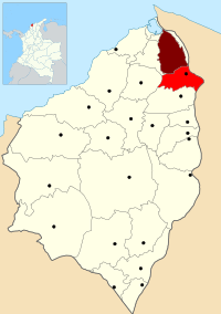 Location of the municipality and town of Soledad in the Department of Atlántico. | |||
 Soledad Location in Colombia | |||
| Coordinates: 10°55′N 74°45′W / 10.917°N 74.750°W | |||
| Country |
| ||
| Region | Caribbean | ||
| Department | Atlántico | ||
| Founded | 1598 | ||
| Government | |||
| • Mayor | Franco Castellanos | ||
| Area | |||
| • Total | 67 km2 (26 sq mi) | ||
| Elevation | 5 m (16 ft) | ||
| Population (2005)[1] | |||
| • Total | 455,796 | ||
| Demonym | Soledeño | ||
| Area code(s) | 57 + 5 | ||
| Website | Official website (Spanish) | ||
.svg.png)

Soledad (Spanish pronunciation: [soleˈðað]) is a municipality in the Colombian Departments of Colombia of Atlántico part of the metropolitan area of Barranquilla. It is 6th in population in Colombia and 3rd in the Caribbean region, after Barranquilla and Cartagena. It is also the city with the highest population growth in Colombia and in 2005 was 455,734 and 2010 580,851.
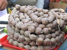
Butifarras soledeñas (sausage of Soledad) is a regional specialty. The area is also known for its Cumbia music.
Limitations
Bordered on the north by the special district of Barranquilla, where the boundary is the Arroyo Don Juan, on the south by Malambo, on the east with the Department of Magdalena, separated by the Magdalena River, and on the west by Galapa.
Geography
Physical Description: The location of the municipality of Soledad in relation to geographical coordinates is as follows: 10°55'N and 74°46'W.
Transportation
References
- (Spanish) Gobernacion del Atlantico - Soledad
| ||||||||
Coordinates: 10°55′N 74°45′W / 10.917°N 74.750°W