Solana, Cagayan
| Solana | ||
|---|---|---|
| Municipality | ||
| ||
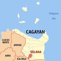
 Map of Cagayan showing the location of Solana | ||
.svg.png) Solana Location within the Philippines | ||
| Coordinates: 17°39′18″N 121°41′20″E / 17.65500°N 121.68889°ECoordinates: 17°39′18″N 121°41′20″E / 17.65500°N 121.68889°E | ||
| Country | Philippines | |
| Region | Cagayan Valley (Region II) | |
| Province | Cagayan | |
| District | 3rd District | |
| Barangays | 38 | |
| Government[1] | ||
| • Mayor | Meynard Z. Carag | |
| Area[2] | ||
| • Total | 234.60 km2 (90.58 sq mi) | |
| Population (2010)[3] | ||
| • Total | 76,596 | |
| • Density | 330/km2 (850/sq mi) | |
| Time zone | PST (UTC+8) | |
| ZIP code | 3503 | |
| Dialing code | 78 | |
| Income class | 1st class | |
Solana is a first class municipality in the province of Cagayan, Philippines. According to the 2010 census, it has a population of 76,596 people.[3]
Barangays
Solana is politically subdivided into 38 barangays.[2]
- Andarayan North
- Lannig
- Bangag de uki
- Bantay
- Basi East
- Bauan East
- Cadaanan
- Calamagui
- Carilucud
- Cattaran
- Centro Northeast (Pob.)
- Centro Northwest (Pob.)
- Centro Southeast (Pob.)
- Centro Southwest (Pob.)
- Lanna
- Lingu
- Maguirig
- Nabbotuan
- Nangalisan
- Natappian West
- Natappian East
- Padul
- Palao
- Parug-parug
- Pataya
- Sampaguita
- Maddarulug (Santo Domingo)
- Ubong
- Dassun
- Furagui
- Gadu
- Iraga
- Andarayan South
- Basi West
- Bauan West
- Calillauan
- Gen. Eulogio Balao
- Malalam-Malacabibi
Demographics
| Population census of Solana | ||
|---|---|---|
| Year | Pop. | ±% p.a. |
| 1990 | 56,366 | — |
| 1995 | 60,346 | +1.29% |
| 2000 | 67,512 | +2.43% |
| 2007 | 71,475 | +0.79% |
| 2010 | 76,596 | +2.55% |
| Source: National Statistics Office[3] | ||
References
- ↑ "Official City/Municipal 2013 Election Results". Intramuros, Manila, Philippines: Commission on Elections (COMELEC). 11 September 2013. Retrieved 24 January 2014.
- ↑ 2.0 2.1 "Province: CAGAYAN". PSGC Interactive. Makati City, Philippines: National Statistical Coordination Board. Retrieved 24 January 2014.
- ↑ 3.0 3.1 3.2 "Total Population by Province, City, Municipality and Barangay: as of May 1, 2010". 2010 Census of Population and Housing. National Statistics Office. Retrieved 24 January 2014.
External links
 |
Piat | Amulung | Cagayan River / Tuguegarao |  |
| Tuao | |
|||
| ||||
| | ||||
| Pinukpuk, Kalinga | Rizal, Kalinga / Enrile | Cagayan River / Iguig |
| ||||||||||||||||||
