Snelling Avenue (Metro Transit station)
Snelling Avenue | |||||||||||
|---|---|---|---|---|---|---|---|---|---|---|---|
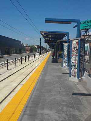
 The west half of Snelling Avenue | |||||||||||
| Coordinates | 44°57′20.48″N 93°10′1.17″W / 44.9556889°N 93.1669917°WCoordinates: 44°57′20.48″N 93°10′1.17″W / 44.9556889°N 93.1669917°W | ||||||||||
| Owned by | Metro Transit | ||||||||||
| Line(s) | |||||||||||
| Platforms | Split side platforms | ||||||||||
| Connections | 16, 21, 84[1] | ||||||||||
| Construction | |||||||||||
| Disabled access | Yes | ||||||||||
| History | |||||||||||
| Opened | June 14, 2014 | ||||||||||
| Traffic | |||||||||||
| Passengers (projected 2030) | 2,540 per weekday[1] | ||||||||||
| Services | |||||||||||
| |||||||||||
Snelling Avenue is a light rail station along the METRO Green Line in Saint Paul, Minnesota. It is located along University Avenue on either side of the intersection with Snelling Avenue. The station has split side platforms, with the westbound platform on the north side of the tracks west of Snelling, and the eastbound platform on the south side of the tracks east of the intersection.[2] This might be Minnesota's busiest intersection, with 64,000 cars passing through it daily.[3]
Construction in this area began in 2011.[4] The station opened along with the rest of the line in 2014.
References
- ↑ 1.0 1.1 "Snelling Avenue Station". Central Corridor. Metropolitan Council. Retrieved November 10, 2011.
- ↑ "Central Corridor light rail illustrated plans". Central Corridor. Metropolitan Council. June 28, 2010. Retrieved September 16, 2010.
- ↑ Millett, Larry (2007). AIA Guide to the Twin Cities: The Essential Source on the Architecture of Minneapolis and St. Paul. Minnesota Historical Society Press, p. 502, 505. ISBN 0-87351-540-4
- ↑ "Central Corridor LRT construction schedule at a glance". Central Corridor. Metropolitan Council. July 20, 2010. Retrieved September 16, 2010.