Snares Islands / Tini Heke
| Tini Heke (Māori) | |
|---|---|
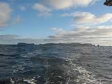 Snares Islands seen from the north-east, with Broughton Island on the left and Dapton Rocks on the right | |
 The position of The Snares relative to New Zealand | |
| Geography | |
| Coordinates | 48°01′S 166°32′E / 48.017°S 166.533°E |
| Area | 3.5 km2 (1.4 sq mi) |
| Country | |
|
New Zealand | |
| Demographics | |
| Population | 0 |


Snares Islands/Tini Heke,[1] also known as The Snares, is a small island group lying about 200 km south of New Zealand's South Island and to the south-south-west of Stewart Island/Rakiura. The Snares consist of the main North East Island and the smaller Broughton Island as well as the Western Chain Islands some 5 km (3.1 mi) to the west-south-west. Collectively, the Snares have a total land area of 3.5 km2 (1.35 sq mi).
History
The island group was first sighted by Europeans on 23 November 1791 independently by the two ships HMS Discovery under Captain George Vancouver, and HMS Chatham commanded by Lieutenant William R. Broughton, both of the Vancouver Expedition. Vancouver named the islands "The Snares" because he considered them a shipping hazard; an islet east of the Western Chain bears the name Vancouver Rock, and the second largest island is named after Broughton. The islands were already known to the Māori, who called one of the larger islands Te Taniwha ("The sea-monster"). Unlike other subantarctic islands that were greatly affected by the whaling and sealing industry in the 19th century, the Snares remain one of the last pristine areas in New Zealand.
The Ngai Tahu Claims Settlement Act 1998 officially altered the name to "Snares Islands/Tini Heke" - one of many such changes under the Ngāi Tahu Treaty settlement.[2]
Environment
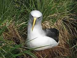
The islands provide a home to endemic bird species such as the Snares penguin (Eudyptes robustus), the Snares snipe (Coenocorypha huegli) and Snares tomtit (Petroica macrocephala dannefaerdi), as well as to several endemic invertebrates. North East Island is forested and is the world's premier breeding area for the sooty shearwaters (Puffinus griseus) with up to 3 million individuals being present during the breeding season (November–April). A dangerous reef (Seal Reef) lies ten kilometres to the south of the group. Megaherb communities grow on the islands.
The islands enjoy a status of high protection and are rated by the New Zealand Department of Conservation as "minimum impact islands".[3] Landing on the islands is generally prohibited or by special research permit only.
The area is among one of five subantarctic island groups forming the New Zealand Subantarctic Islands, designated as a World Heritage Site by UNESCO.[4]
See also
References
- ↑ "New Zealand Gazetteer of Official Geographic Names - Offshore islands". Land Information New Zealand. Retrieved 22 June 2010.
- ↑ "Schedule 96 Alteration of place names". New Zealand Legislation. Retrieved 22 June 2010.
- ↑ "Subantarctic Islands: Subantarctic places to visit". Retrieved 12 January 2012.
- ↑ New Zealand Sub-Antarctic Islands - UNESCO World Heritage Centre