Smoky Hill Township, Geary County, Kansas
| Smoky Hill Township | |
|---|---|
| Township | |
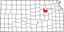
 Location in Geary County | |
| Coordinates: 39°01′27″N 096°50′26″W / 39.02417°N 96.84056°WCoordinates: 39°01′27″N 096°50′26″W / 39.02417°N 96.84056°W | |
| Country | United States |
| State | Kansas |
| County | Geary |
| Area | |
| • Total | 65.25 sq mi (168.99 km2) |
| • Land | 57.52 sq mi (148.97 km2) |
| • Water | 7.73 sq mi (20.02 km2) 11.85% |
| Elevation | 1,138 ft (347 m) |
| Population (2000) | |
| • Total | 4,974 |
| • Density | 86.5/sq mi (33.4/km2) |
| GNIS feature ID | 0476557 |
Smoky Hill Township is a township in Geary County, Kansas, USA. As of the 2000 census, its population was 4,974.
History
Smoky Hill Township was organized in 1872.[1]
Geography
Smoky Hill Township covers an area of 65.25 square miles (169.0 km2) and contains one incorporated settlement, Fort Riley-Camp Whiteside. According to the USGS, it contains three cemeteries: Alda, Alida and Saint Johns.
The streams of Curtis Creek, Fourmile Creek, Onemile Creek, Republican River, School Creek and Smoky Hill River run through this township.
Transportation
Smoky Hill Township contains one airport or landing strip, Ritter Airport (historical).
References
- ↑ "Geary County History (archived)". Geary County Historical Society. Retrieved 10 June 2014.
External links
| |||||||||||||||||||||||||||||