Slivna
For the Romanian village, see Bereşti-Meria.
| Slivna | |
|---|---|
 | |
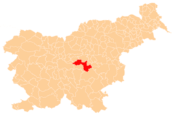
_location_map.svg.png) Slivna Location in Slovenia | |
| Coordinates: 46°7′20.96″N 14°48′56.21″E / 46.1224889°N 14.8156139°ECoordinates: 46°7′20.96″N 14°48′56.21″E / 46.1224889°N 14.8156139°E | |
| Country |
|
| Traditional region | Lower Styria |
| Statistical region | Central Slovenia |
| Municipality | Litija |
| Area | |
| • Total | 3.47 km2 (1.34 sq mi) |
| Elevation | 626.6 m (2,055.8 ft) |
| Population (2002) | |
| • Total | 136 |
| [1] | |
Slivna is a settlement west of Vače the Municipality of Litija in central Slovenia. The area was traditionally part of Lower Styria and is now included with the rest of the municipality in the Central Slovenia statistical region.[2] The settlement is the Geometric Centre of the Republic of Slovenia.
The local church, built in the hamlet of Zgornja Slivna, is dedicated to Saint Agnes (Slovene: sveta Neža) and belongs to the Parish of Vače. It is a late 14th-century church that was restyled in the Baroque in the late 17th to early 18th centuries.[3]