Slåtterøy Lighthouse
 View of the lighthouse | |
 | |
| Location | Hordaland, Norway |
|---|---|
| Coordinates | 59°54′29″N 05°04′01″E / 59.90806°N 5.06694°ECoordinates: 59°54′29″N 05°04′01″E / 59.90806°N 5.06694°E |
| Year first constructed | 1859 |
| Automated | 2003 |
| Construction | Iron tower |
| Height | 25.1 metres (82 ft) |
| Focal height | 45.8 metres (150 ft) |
| Intensity | 5,180,000 cd |
| Range | 18.5 nmi (34.3 km; 21.3 mi) |
| Characteristic | Fl(2) W 30s |
| Racon | T |
| Admiralty number | B3752 |
| NGA number | 3384 |
| ARLHS number | NOR-216 |
| Norway number | 153500 |
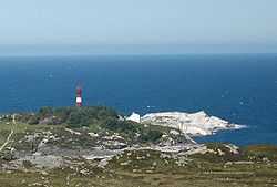
Slåtterøy Lighthouse (Norwegian: Slåtterøy fyr) is a coastal lighthouse located in the municipality of Bømlo in southwestern Hordaland county, Norway. It sits at the western entrance to the Selbjørnsfjorden, marking an island-filled area northeast of Bømlo and northwest of Stord. The lighthouse was established in 1859 and fully automated in 2003. The 25-metre (82 ft) round, cast iron tower is painted red with one white horizontal band. At the top, there is a light that emits a 5,180,000 candela, the highest intensity among all lighthouses in Norway. The light sits at an elevation of 45.8 metres (150 ft) above sea level and it emits a white light in the pattern of 2 flashes every 30 seconds.[1][2][3]
The lighthouse was listed as a protected site in 2000 and in 2003 it was fully automated. The ownership of the site was then transferred to the municipal government. Overnight accommodations are available, as are guided tours. The site is only accessible by boat from the nearby island of Gisøy.[2][4]
References
- ↑ Kystverket (2014). Norske Fyrliste 2014 (PDF) (in Norwegian). ISBN 9788245015959.
- ↑ 2.0 2.1 Rowlett, Russ (19 July 2011). "Lighthouses of Norway: Leirvik Area". University of North Carolina at Chapel Hill. Retrieved 2015-02-19.
- ↑ Henriksen, Petter (ed.). "Slåtterøy fyr". Store norske leksikon (in Norwegian). Oslo: Kunnskapsforlaget. Retrieved 17 December 2011.
- ↑ "Slåtterøy fyrstasjon" (in Norwegian). Norsk Fyrhistorisk Forening. Retrieved 17 December 2011.