Sizihwan Station
Sizihwan Station (NSYSU) (Hamasing) 西子灣站 (中山大學) (哈瑪星) | |
 | |
|---|---|
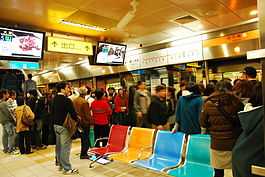
| Sizihwan Station Platform | |
| Location | |
| Municipality | Kaohsiung |
| District(s) | Gushan |
| Info | |
| Type | Underground |
| Platforms | 1 island platform |
| Accessible | |
| History | |
| Opened | September 14, 2008 |
| Rail services | |
| Line(s) | Orange Line (O1) |
| Daily Ridership | 5,697 (Jan. 2011)[1] |
| Operator(s) | Kaohsiung Rapid Transit Corporation |
| Sizihwan Station | |||||||||||||
| Traditional Chinese | 西子灣站 | ||||||||||||
|---|---|---|---|---|---|---|---|---|---|---|---|---|---|
| Simplified Chinese | 西子湾站 | ||||||||||||
| |||||||||||||
Sizihwan Station (西子灣站) is a terminal station of the Orange Line of KMRT. It is located in Hamasing of Gushan District, Kaohsiung. Its name is derived from Sizihwan, a nearby scenic area.
Station overview
The nearby TRA Kaohsiung Port Station (高雄港站) closed after service began on the Orange Line through this station. It opened in 1908 to begin train service into the Kaohsiung Harbor area. The train station area will be turned into a railway cultural park.[2]
Station design
The station is a two-level, underground station with an island platform.[3] It is located at the junction of Linhai 2nd Road and Gushan 1st Road and has 2 exits. The station is 282 metres (925 ft) long.[4]
Station layout
| Street Level | Entrance/Exit | Entrance/Exit |
| B1 | Concourse | Lobby, information desk, automatic ticket machines, one-way faregates |
| Restrooms (Near Exits 2) | ||
| B2 | Platform 1 | → KMRT Orange Line toward Daliao (Yanchengpu) → |
| Platform 2 | → KMRT Orange Line toward Daliao (Yanchengpu) → | |
Exits
- Exit 1: Gushan Ferry Station, Gushan Post Office

- Exit 2: Kaohsiung Customs, Kaohsiung Fisherman's Wharf
Around the station
- Bank of Taiwan, Gushan Branch
- Chunghwa Post, Gushan Post Office
- Former British Consulate at Takao
- Gushan Elementary School
- Gushan Ferry Station
- Gushan Market
- Kaohsiung Fisherman's Wharf
- Kaohsiung Harbor
- Kaohsiung Harbor Museum
- Kaohsiung Martyrs' Shrine
- Kaohsiung Port Station
- National Sun Yat-sen University
- North Gate of Xiong Town
- Shaochuantou Park
- Mount Shou
- Takao Railway Museum
- Wude Martial Arts Center
Nearby stations
| Preceding station | Kaohsiung MRT | Following station | ||
|---|---|---|---|---|
| Terminus | Orange Line | toward Daliao |
References
| Wikimedia Commons has media related to Sizihwan Station. |
- ↑ "統計資訊 > 統計月報". Transportation Bureau, Kaohsiung City Government. Retrieved 2011-02-15.
- ↑ "Old locomotives set to retire from Kaohsiung after 100 years of service". Taiwan News. 2008-11-08. Retrieved 2010-07-05.
- ↑ "西子灣站". 高雄捷運公司. Retrieved 2010-07-05.
- ↑ "西子灣站週邊地圖". 高雄捷運公司. Retrieved 2010-07-05.
Coordinates: 22°37′18″N 120°16′28″E / 22.621565°N 120.274516°E