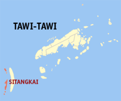
Sitangkai, Tawi-Tawi
| Sitangkai | |
|---|---|
| Municipality | |
 Map of Tawi-Tawi with Sitangkai highlighted | |
.svg.png) Sitangkai Location within the Philippines | |
| Coordinates: 04°40′N 119°24′E / 4.667°N 119.400°ECoordinates: 04°40′N 119°24′E / 4.667°N 119.400°E | |
| Country | Philippines |
| Region | Autonomous Region in Muslim Mindanao (ARMM) |
| Province | Tawi-Tawi |
| District | Lone district of Tawi-Tawi |
| Founded | August 26, 1959 |
| Barangays | 9 |
| Government[1] | |
| • Mayor | Serbin Canon Ahaja |
| • Vice Mayor | Tiblan Canon Ahaja |
| Population (2010)[2] | |
| • Total | 30,514 |
| Time zone | PST (UTC+8) |
| ZIP code | 7506 |
| Dialing code | 68 |
| Income class | 2nd |
Sitangkai is a second class municipality in the province of Tawi-Tawi, and it is the southernmost settlement of the Philippines. According to the 2010 census, it has a population of 30,514 people.[2]
It is called the "Venice of the Philippines" due to the use of boats as primary transportation, although footbridges connect one house from another. The major sources of livelihood are fishing and farming, although there is very sparse agricultural land available.
History
Sitangkai was created as a municipality on August 26, 1959, by virtue of Executive Order No. 355 of President Carlos P. Garcia. On October 21, 2006, with the ratification of Muslim Mindanao Autonomy Act No. 197, 16 of its 25 barangays were transferred to the newly created municipality of Sibutu. All of which are located on Sibutu Island.
Barangays
Sitangkai is politically subdivided into 9 barangays.[2]
- Datu Baguinda Putih
- Imam Sapie
- North Larap
- Panglima Alari
- Sipangkot
- Sitangkai Poblacion
- South Larap (Larap)
- Tongmageng
- Tongusong
Demographics
| Population census of Sitangkai | ||
|---|---|---|
| Year | Pop. | ±% p.a. |
| 1990 | 34,493 | — |
| 1995 | 36,027 | +0.82% |
| 2000 | 52,772 | +8.53% |
| 2007 | 40,641 | −3.54% |
| 2010 | 30,514 | −9.90% |
| Source: National Statistics Office[2] | ||
References
- ↑ "Official City/Municipal 2013 Election Results". Intramuros, Manila, Philippines: Commission on Elections (COMELEC). 1 July 2013. Retrieved 5 September 2013.
- ↑ 2.0 2.1 2.2 2.3 "Total Population by Province, City, Municipality and Barangay: as of May 1, 2010". 2010 Census of Population and Housing. National Statistics Office. Retrieved 1 September 2014.
External links
 |
|
Sulu Sea |  | |
| Darvel Bay | |
Sibutu | ||
| ||||
| | ||||
| |
Celebes Sea |
| ||||||||||