Sira Taluk
| Sira Taluk Sira | |
|---|---|
| taluk and town | |
 Sira Taluk Location in Karnataka, India | |
| Coordinates: 13°44′42″N 76°54′32″E / 13.745°N 76.909°ECoordinates: 13°44′42″N 76°54′32″E / 13.745°N 76.909°E | |
| Country |
|
| State | Karnataka |
| District | Tumkur district |
| Languages | |
| • Official | Kannada |
| Time zone | IST (UTC+5:30) |
| PIN | 572 137 |
| Vehicle registration | KA-06 |
Sira is a taluk of Tumkur district in the state of Karnataka, India. Its headquarters, Sira town lies on the National Highway NH-4 (Bangalore – Poona).
History
Sira was politically and militarily an important region of south India prior to the British Raj. Sira Province was ruled by the Bijapur Kings from 1638 to 1687. The Suba or Province of Sira of the Mughal Empire with its capital at Sira town lasted from 1687 to 1757. The Marathas wrested the province from Mughals and held it from 1757 to 1759, when the Mughals regained it. In 1761, Haidar Ali whose father Sheikh Fateh Mohammed occupied an important position in the local Mughal Army declared his independence from the Mughal Empire and declared himself the 'Nawab' of the province. He called himself 'Nawab Haider Ali Bahadur' but lost the province to the Marathas from 1766 until 1774 when his son Tipu Sultan, captured it for him.[1]
Historical places in Sira Taluk
Like most other places of historical importance in India, Sira also has religious structures built by its erstwhile rulers. Among them are:
- Kasturi Rangappa Nayaka Fort: This beautiful fort is named after the 'Nayaka' ruler. It is symbolic of the hold the Nayaka community rulers once had on Sira.later SHAIK FATEH MOHAMMED father of HAIDER ALI defeated nayakars but it was still under the control of Delhi emperor ASAF UD DAULAH.later NAWAB HAIDER ALI BAHADUR taken back from delhi emperor Asaf ud daulah.
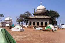
- Mallik Rehan 'dargah' : This is mausoleum over the erstwhile Sira province's governor Mallik Rehan's grave. Mallik Rehan was the Subahdar or Governor of Sira from 1638 to 1650. Some locals revere Mallik Rehan as a pious man and call him Hazrath Mallik Rehan Rahmatullah Alai. This monument is protected by Archeological Society of India (ASI).
- Juma or Jamia Masjid: This was constructed during the period of Mallik Rehan. This monument is protected by Archeological Society of India (ASI)
- Bada (the big) Eidgah
- Sone kalas ka makaan
Other places of special interest in Sira Taluk
- The Big Banyan Tree (Dodda Alada Mara in Kannada): Located just beyond Togarugunte village, north of Sira Town, this is one of the largest Banyan trees in south India. The tree is revered by Hindus as a sacred tree and is protected by the locals. This big banyan tree just 7 km from the sira towards Sira_Amarapura Road. The Local government supported drinking water and benches for travels. The specially the school children s came to a weekend for tourist there is a scope for a good tours em place.
- Kaggaladu heronry: Located on the Sira – Chengavara main road, this is one of Karnataka's largest nesting sites for Painted Stork and Grey Herons. The birds here nest on Tamarind and Peepal trees on both private as well as Government land. The villagers are fond of these winged wonders and make sure these are protected from hunters. The site was made known to the outside world by members of a local NGO Wildlife Aware Nature Club.
- Basavangi Betta and Fort: also known as Bhasmangi Fort.Well placed beautiful almost monolith hill with amazing multiple rounds of fort on top. Bricks used for fort till date are rock hard. Hill top also has quite a few ponds and abandoned mantapas (rooms). It mesmerizing to see the big blocks of rocks stacked on fort built on cliffs. One would wonder how could they lift them up there without modern earth moving equipment.
Pictures
See Also Kote Sri Karegundi Anjaneyaswamy Temple on Sira Madhugiri Road. This is next to the Sira Lake. This is a place of Religious importance and the temple has a history of more than 800 years. People from all around including Bangalore visit to the said Temple especially on the date of Hanuma Jayanthi which comes every Year during the month of December.
See also
- Sira town
- ballajjana hatti (yadava)
- Province of Sira
- Tumkur
- Tumkur District
- Taluks of Karnataka
References
- ↑ [Mysore: A Gazetteer Compiled for the Government, Volume I, Mysore In General]
Bibliography
- Archeological Survey of India, Bangalore circle, List showing protected monuments (For Sira, see Sl. No: 198 & 199)
- Large nesting colony of Painted storks identified near Sira (Karnataka) Ameen Ahmed, Myforest (Quarterly Journal of Karnataka Forest Department), March 1999
- Plea to protect fort in Sira (Story in Deccan Herald, Bangalore, 19 May 2008)