Sira, India
| Sira, Karnataka. ಸಿರಾ | |
|---|---|
| City | |
 Sira, Karnataka. Location in Karnataka, India | |
| Coordinates: 13°44′42″N 76°54′32″E / 13.745°N 76.909°ECoordinates: 13°44′42″N 76°54′32″E / 13.745°N 76.909°E | |
| Country |
|
| State | Karnataka |
| District | Tumkur district |
| Government | |
| • Body | city municipal council |
| Area | |
| • Total | 17.47 km2 (6.75 sq mi) |
| Elevation | 661 m (2,169 ft) |
| Population (2011) | |
| • Total | 105,012 |
| • Density | 2,867.09/km2 (7,425.7/sq mi) |
| Languages | |
| • Official | Kannada |
| Time zone | IST (UTC+5:30) |
| PIN | 572 137 |
| Telephone code | 08135 |
| Vehicle registration | KA-06 |
| MLA. = T B Jayachandra
Sira is a City and taluk headquarters of Sira Taluk of Tumkur district in the state of Karnataka, India. It lies on the National Highway NH-4 (Mumbai - Chennai) and NH-234 (Mangalore - Villupuram).
Geography
Sira is located at 13°45′N 76°55′E / 13.75°N 76.91°E.[1] It has an average elevation of 662 metres (2171 feet).
Demographics
As of 2001 India census,[2] Sira had a population of 50,056. Males constitute 52% of the population and females 48%. Sira has an average literacy rate of 67%, higher than the national average of 59.5%: male literacy is 72%, and female literacy is 62%. In Sira, 13% of the population is under 6 years of age.
History
Sira Town was one of south India's strategically important places prior to the British Raj.
The foundation of the town and the fort is attributed to Rangappa Nayaka, a chief of Ratnagiri. The previous name of the town was Siriya.The beautiful fort is named after the 'Nayaka' ruler. It is symbolic of the hold the Nayaka community rulers once had on Sira.we can
still see the remains of beautiful fort which is situated adjacent to
Doddakere.
It was ruled by the Bijapur Kings from 1638 to 1687. It was the capital of the erstwhile Suba or Province of Sira of the Mughal Empire that lasted from 1687 to 1757. The Marathas wrested the province from Mughals and held it from 1757 to 1759, when the Mughals regained it. Haidar Ali declared himself the Nawab of the province in 1761 only to lose it to the Marathas from 1766 until 1774 when his son Tipu Sultan, captured it for him.[3]
Historical places in Sira City
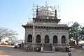
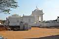
Like most other places of historical importance in India, Sira also has structures built by its erstwhile rulers. Among them are the Sira fort, all people of sira taluk worship durgamma hence it is called Sri grama devate durga devate this temple is very famous temple people come from so many cities and every casts people worship and give a visit every year on navarathri utsava and dasara and according to some info it is also called as second Mysore dasara, Eidgah, Juma Masjid and the dargah or tomb over the grave of Mallik Rehan, who was the Subahdar of Sira. The Jumma Masjid and the tomb of Malik Rihan (1651 A.D) are fine structures built in the Mughal style of architecture.
- Kasturi Rangappa Nayaka Fort: This beautiful fort is named after the 'Nayaka' ruler. It is symbolic of the hold the Nayaka community rulers once had on Sira. The fort is also a good structure of stone with a moat all round. The ruins of a large quarter, to which tradition assigns the name of Latapura can still be seen to the north-west of the fort. The main image of the Gopalakrishna temple here has been removed to the newly built Narayana temple and a good figure of Hanuman, brought from some other place has been set up instead. The object of worship in the Durga temple is an ant hill.
- SRI GRAMA DEVATE DURGA DEVI TEMPLE
File:SRI_GRAMA_DEVATAE_DURGAMMA3.jpg
- Khan Bagh:A fine garden called the Khan Bagh was founded here by Dilavar Khan, an officer under the Mughuls. This was kept up by Haider and might have suggested the Lalbagh garden at Bangalore.[4]
- Ibrahim Rauza: It contains many tombs and is a fine example of Muslim architecture.
- Mallik Rehan 'dargah' : This is mausoleum over the erstwhile Sira province's governor Mallik Rehan's grave. Mallik Rehan was the Subahdar or Governor of Sira from 1638 to 1650. Some locals revere Mallik Rehan as a pious man and call him Hazrath Mallik Rehan Rahmatullah Alai. This monument is protected by Archeological Survey of India (ASI).
- Juma or Jamia Masjid: This was constructed during the period of Mallik Rehan. This monument is also protected by ASI.
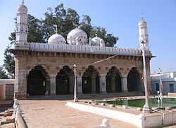 The Mughal-era Juma Masjid in Sira town
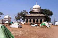 The tomb of Mallik Rehan, Sira town
- Bada (the big) Eidgah
- Seebi: Formerly known as Sibur and Harihararayapura, the Seebi village is midway (24 km) between Tumkur town and Sira Towns along the Bangalore-Mumbai National Highway. It has a big stone temple of Narasimhaswamy. The image of Narasimha in the temple is in the form of a saligrama. The ten avataras of Vishnu, the leelas (sports) of Shiva and the scenes from the Ramayana and Mahabharata are painted on the beams and ceilings of the temple. These paintings appear to be of the latter part of the 18th century A.D. caused to be drawn by one Nallappa, an officer under Tipu Sultan. They are contemporaneous to the paintings at Srirangapattana. (Source: Karnataka State Gazetteer 1983)
- SRI GRAMA DEVATE DURGA DEVI TEMPLE
File:SRI_GRAMA_DEVATAE_DURGAMMA3.jpg
Road
Sira is well connected to all nearby district headquarters.
Rail
Still no railway station here, but soon it may have the sophisticated railway link to Davanagere to Blore via Sira to Tumkur :)
Air
Nearby airport is Kempe Gowda International Airport, Devanahalli
Gallery
Education
Primary schools
- Poonam English high school
- Al Ameen educational trust
- Ar Rehan Educational Trust
- Vasavi Vidya Samasthe
- Sri Madhava Vidhya Mandira
- ST.Annes school sira
- Smart kids
- Manjushree School
- St. anns school
- The Presidency Public school of education Presidency school, Amarapura road, sira
Higher Education
- Government Pre-university college
- Government degree college
- Ranganatha Pre-university college
- Presidency Pre-university college
- Sri durga ITI college
Nearest Engineering college @ tumkur
- Shreedevi Group Of Educational Institutions -SIET Shridevi Institute of Technology
Nearest Polytechnic college @ tumkur
- Govt polytechnic College
- HMS polytechnic College
- Arya Bharathi polytechnic College
- Siddaganga polytechnic College
External links
| Wikimedia Commons has media related to Sira, India. |
See also
- Sira Taluk
- Province of Sira
- Tumkur
- Tumkur District
- Taluks of Karnataka
References
- ↑ Falling Rain Genomics, Inc - Sira
- ↑ "Census of India 2001: Data from the 2001 Census, including cities, villages and towns (Provisional)". Census Commission of India. Archived from the original on 2004-06-16. Retrieved 2008-11-01.
- ↑ [Mysore: A Gazetteer Compiled for the Government, Volume I, Mysore In General]
- ↑ "TUMKUR DISTRICT TOURIST PLACES".
- Benjamin Rice, Lewis, Mysore: A Gazetteer Compiled for the Government, Volume I, Mysore In General, 1897a, Westminster: Archibald Constable and Company. Pp. xix, 834
- Archeological Survey of India, Bangalore circle, List showing protected monuments (For Sira, see Sl. No: 198 & 199)
- Plea to protect fort in Sira (Story in Deccan Herald, Bangalore, May 19, 2008)