Sir Richard Peninsula
| Sir Richard Peninsula South Australia | |
|---|---|
|
Goolwa Beach | |
 Sir Richard Peninsula | |
| Coordinates | 35°32′25″S 138°50′21″E / 35.54028°S 138.83917°ECoordinates: 35°32′25″S 138°50′21″E / 35.54028°S 138.83917°E |
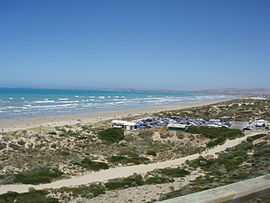
Sir Richard Peninsula is a narrow peninsula consisting of sand which extends from Goolwa, South Australia to the Murray Mouth. It separates the Goolwa Channel which is part of the estuary of the River Murray from Encounter Bay. It is approximately 10 kilometres long and ranges from 500m to one kilometre in width. The peninsula together with the Younghusband Peninsula on the eastern side of the Murray Mouth, is the primary sand dune line defining this stretch of the Australian coastline. Sir Richard Peninsula was named after Richard Graves MacDonnell, the sixth governor of South Australia.[1][2][3][4]
References
- ↑ "Sir Richard Peninsula". Gazetteer of Australia online. Geoscience Australia, Australian Government.
- ↑ "Sir Richard Peninsula". SA Water. Retrieved 23 January 2014.
- ↑ "Search results for “Sir Richard Peninsula, PEN”". Department of Planning Transport and Infrastructure. 6 December 2011. Retrieved 5 December 2014.
- ↑ Boating Industry Association of South Australia (BIA); South Australia. Department for Environment and Heritage (2005), South Australia's waters an atlas & guide, Boating Industry Association of South Australia, p. 27, ISBN 978-1-86254-680-6