Sils im Engadin/Segl
| Sils im Engadin/Segl | ||
|---|---|---|
|
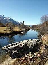
Sils and Lake Sils | ||
| ||
 Sils im Engadin/Segl | ||
|
Location of Sils im Engadin/Segl 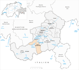 | ||
| Coordinates: 46°26′N 9°46′E / 46.433°N 9.767°ECoordinates: 46°26′N 9°46′E / 46.433°N 9.767°E | ||
| Country | Switzerland | |
| Canton | Graubünden | |
| District | Maloja | |
| Area[1] | ||
| • Total | 63.57 km2 (24.54 sq mi) | |
| Elevation | 1,803 m (5,915 ft) | |
| Population (Dec 2013[2]) | ||
| • Total | 756 | |
| • Density | 12/km2 (31/sq mi) | |
| Postal code | 7514 | |
| SFOS number | 3789 | |
| Localities | Sils-Maria, Sils-Baselgia, Val Fex as well as Grevasalvas, Blaunca and Buaira | |
| Surrounded by | Bivio, Chiesa in Valmalenco (IT-SO), Lanzada (IT-SO), Samedan, Silvaplana, Stampa | |
| Website |
www SFSO statistics | |

Sils im Engadin/Segl (German: Sils im Engadin; Romansh ![]() Segl ) is a municipality in the district of Maloja in the Swiss canton of Graubünden.
Segl ) is a municipality in the district of Maloja in the Swiss canton of Graubünden.
Name and coat of arms
The municipality's name is a combination of the German and Romansh names. Sils im Engadin is the German name while Segl is the Romansh. The coat of arms is Per fess Azure a Sun radiated Or and Or a Trout Azure spotted Gules.[3] It shows a blue upper half with a golden sun and a yellow lower section with a blue trout. It is a combination of the historical village coats of arms and represents the sunny and elevated location of the municipality and the fish-filled Lake Sils.
History
Sils im Engadin/Segl is first mentioned around 800-850 as Silles. In 1131 it was mentioned as Sillis.[4]
Geography
Sils im Engadin/Segl has an area, as of 2006, of 63.5 km2 (24.5 sq mi). Of this area, 27.8% is used for agricultural purposes, while 10.2% is forested. Of the rest of the land, 1.1% is settled (buildings or roads) and the remainder (61%) is non-productive (rivers, glaciers or mountains).[5]
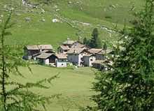
The municipality is located in the Maloja district. It consists of the village of Sils im Engadin/Segl which is made up of the sections of Sils-Maria, Sils-Baselgia, Fex, and Grevasalvas. Until 1943, Sils im Engadin/Segl was known as Sils im Engadin.[6]
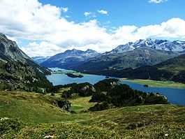
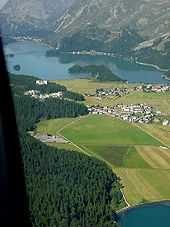
Located in the Upper Engadin valley, Sils nestles between Lake Sils and Lake Silvaplana at the foot of Piz Corvatsch and Piz da la Margna and below the Fex valley. Sils was originally divided into the two hamlets of Sils-Baselgia and Sils-Maria, but the two now almost form a continuum. The town is in a flat plain between the two lakes, with steep slopes on either side. The plain is cultivated in grass, the steep slopes are heavily forested.
Demographics
Sils im Engadin/Segl has a population (as of 31 December 2013) of 756.[2] As of 2008, 29.3% of the population was made up of foreign nationals.[7] From 1999 to 2009, the population grew at a rate of 19.7%.[5]
As of 2000, the gender distribution of the population was 48.3% male and 51.7% female.[8] The age distribution, as of 2000, in Sils im Engadin/Segl is; 64 children or 8.5% of the population are between 0 to 9 years old. 35 teenagers or 4.7% are 10 to 14, and 40 teenagers or 5.3% are 15 to 19. Of the adult population, 135 people or 18.0% of the population are between 20 to 29 years old. 164 people or 21.8% are 30 to 39, 117 people or 15.6% are 40 to 49, and 88 people or 11.7% are 50 to 59. The senior population distribution is 57 people or 7.6% of the population are between 60 to 69 years old, 36 people or 4.8% are 70 to 79, there are 13 people or 1.7% who are 80 to 89, and there are 2 people or 0.3% who are 90 to 99.[7]
In the 2007, federal election the most popular party was the SVP which received 34.6% of the vote. The next three most popular parties were the SP (29.3%), the FDP (26.6%) and the CVP (7.2%).[5]
In Sils im Engadin/Segl, about 70.6% of the population (between age 25-64) have completed either non-mandatory upper secondary education or additional higher education (either university or a Fachhochschule).[5]
Sils im Engadin/Segl has an unemployment rate of 2.93%. As of 2005, there were 23 people employed in the primary economic sector and about 9 businesses involved in this sector. 177 people are employed in the secondary sector and there are 16 businesses in this sector. 671 people are employed in the tertiary sector, with 58 businesses in this sector.[5]
The historical population is given in the following table:[4][8]
| year | population |
|---|---|
| 1850 | 219 |
| 1900 | 178 |
| 1930 | 359 |
| 1950 | 262 |
| 1960 | 298 |
| 1970 | 403 |
| 1980 | 434 |
| 1990 | 498 |
| 2000 | 751 |
Languages
Most of the population (as of 2000) speaks German (59.4%), with Italian being second most common (15.4%) and Romansh being third (12.0%).[5] Into the 19th century, the entire population spoke the Upper-Engadin Romansh dialect of Putèr. Due to increasing trade with the outside world, Romansh usage began to decline. In 1880 about 68% spoke Romansh as a first language, while in 1910 it was only 56% and in 1941 it increased to 61.5%. In the 1960s German became the majority language. However, in 2000 there were 33% of the population who at least understood Romansh.
| Languages in Sils im Engadin/Segl | ||||||
| Languages | Census 1980 | Census 1990 | Census 2000 | |||
| Number | Percent | Number | Percent | Number | Percent | |
| German | 210 | 48.39% | 291 | 58.43% | 446 | 59.39% |
| Romansh | 137 | 31.57% | 122 | 24.50% | 90 | 11.98% |
| Italian | 67 | 15.44% | 71 | 14.26% | 116 | 15.45% |
| Population | 434 | 100% | 498 | 100% | 751 | 100% |
Transportation
The Fex valley is officially car-free except for residents of the valley. The Furtschellas cable car begins near the village and leads to many ski runs and, in summer, to trails above the tree line.
Climate
| Climate data for Segl-Maria (1981-2010) | |||||||||||||
|---|---|---|---|---|---|---|---|---|---|---|---|---|---|
| Month | Jan | Feb | Mar | Apr | May | Jun | Jul | Aug | Sep | Oct | Nov | Dec | Year |
| Average high °C (°F) | −0.1 (31.8) |
1.0 (33.8) |
3.6 (38.5) |
5.8 (42.4) |
10.8 (51.4) |
14.6 (58.3) |
17.5 (63.5) |
17.0 (62.6) |
13.4 (56.1) |
9.5 (49.1) |
4.0 (39.2) |
0.4 (32.7) |
8.1 (46.6) |
| Daily mean °C (°F) | −6.8 (19.8) |
−6.5 (20.3) |
−2.9 (26.8) |
0.7 (33.3) |
5.6 (42.1) |
9.1 (48.4) |
11.5 (52.7) |
11.2 (52.2) |
8.0 (46.4) |
4.0 (39.2) |
−1.4 (29.5) |
−4.9 (23.2) |
2.3 (36.1) |
| Average low °C (°F) | −12.4 (9.7) |
−12.7 (9.1) |
−8.4 (16.9) |
−3.7 (25.3) |
1.2 (34.2) |
4.2 (39.6) |
6.6 (43.9) |
6.4 (43.5) |
3.4 (38.1) |
−0.3 (31.5) |
−5.4 (22.3) |
−9.3 (15.3) |
−2.5 (27.5) |
| Average precipitation mm (inches) | 48 (1.89) |
36 (1.42) |
51 (2.01) |
70 (2.76) |
105 (4.13) |
114 (4.49) |
114 (4.49) |
124 (4.88) |
101 (3.98) |
95 (3.74) |
92 (3.62) |
61 (2.4) |
1,011 (39.8) |
| Average snowfall cm (inches) | 57 (22.4) |
43.8 (17.24) |
56.5 (22.24) |
50.9 (20.04) |
17.1 (6.73) |
1.8 (0.71) |
0.2 (0.08) |
0.3 (0.12) |
2.7 (1.06) |
13.3 (5.24) |
51.9 (20.43) |
58 (22.8) |
353.5 (139.17) |
| Avg. precipitation days (≥ 1.0 mm) | 6.6 | 5.6 | 6.5 | 8.9 | 11.3 | 11.1 | 10.9 | 11.1 | 8.3 | 8.7 | 8.5 | 8.0 | 105.5 |
| Avg. snowy days (≥ 1.0 cm) | 7.6 | 6.7 | 7.3 | 7.1 | 2.2 | 0.4 | 0 | 0.1 | 0.4 | 1.8 | 6.6 | 7.4 | 47.6 |
| Average relative humidity (%) | 78.2 | 77.1 | 77.0 | 76.7 | 76.6 | 73.3 | 71.9 | 76.6 | 77.9 | 78.0 | 79.1 | 79.4 | 76.8 |
| Source: MeteoSwiss [9] | |||||||||||||
Notable residents and visitors
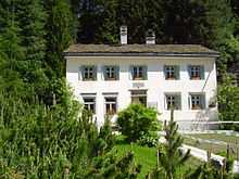
Philosopher Friedrich Nietzsche summered in Sils in 1881 and between 1883 and 1888, and the house he lived in – the Nietzsche-Haus – is now a small museum. Anne Frank was in Sils for several vacations, and Hermann Hesse also visited Sils.
References
- ↑ Arealstatistik Standard - Gemeindedaten nach 4 Hauptbereichen
- ↑ 2.0 2.1 Swiss Federal Statistics Office – STAT-TAB Ständige und Nichtständige Wohnbevölkerung nach Region, Geschlecht, Nationalität und Alter (German) accessed 18 August 2014
- ↑ Flags of the world accessed 21 October 2009
- ↑ 4.0 4.1 Sils im Engadin/Segl in German, French and Italian in the online Historical Dictionary of Switzerland.
- ↑ 5.0 5.1 5.2 5.3 5.4 5.5 Swiss Federal Statistical Office accessed 21-Oct-2009
- ↑ Amtliches Gemeindeverzeichnis der Schweiz published by the Swiss Federal Statistical Office (German) accessed 23 September 2009
- ↑ 7.0 7.1 Graubunden Population Statistics (German) accessed 21 September 2009
- ↑ 8.0 8.1 Graubunden in Numbers (German) accessed 21 September 2009
- ↑ "Climate Norm Value Tables". Climate diagrams and normals from Swiss measuring stations. Federal Office of Meteorology and Climatology (MeteoSwiss). Retrieved 23 January 2013. The weather station elevation is 1798 meters above sea level.
| Wikimedia Commons has media related to Sils im Engadin/Segl. |
External links
- www.sils.ch - Official website of the tourist office
- www.sils-segl.ch - Official website of the municipality
- www.corvatsch.ch - Web site for the Corvatsch-Furtschellas lift system (in German)
- Sils im Engadin/Segl in German, French and Italian in the online Historical Dictionary of Switzerland.
| ||||||||||||