Silifke Castle
| Silifke Castle | |
|---|---|
| Silifke, Mersin Province, Turkey | |
 | |
 Silifke Castle | |
| Coordinates | 36°23′00″N 33°55′00″E / 36.3833333°N 33.9166667°E |
| Type | Fortress |
| Site information | |
| Open to the public | Yes |
| Condition | Large sections of walls are still standing. |
| Site history | |
| Built by | Byzantine Empire |
| Demolished | Partially |
Silifke Castle (Turkish: Silifke kalesi) is a medieval castle in Turkey.
Geography
The castle is in Silifke district of Mersin Province. It is situated to the west of Silifke city center, to the south of Göksu River (Calydanus of the antiquity) and to the north of the Turkish state highway D.715 at 36°23′N 33°55′E / 36.383°N 33.917°E. Although its altitude is only 160 metres (520 ft) with respect to sea level, it is dominant over Silifke plains and the southern section of Göksu valley.
History
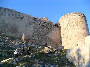
Silifke (ancient Seleucia) was an important town of the antiquity and a castle was built in 4th century BC during the Hellenistic age of Anatolia.[1] Nevertheless, the present castle was built by the Byzantines in the medieval age as a bulwark against Arabs. Towards the end of the 12th century and during the Third Crusade, Armenians captured the castle (under Baron Leo, the future Leo I). However in 1210, Armenians conceded the castle to their allies Knights Hospitaller to defend their west flank from Seljuk Turks. In 1236, the castle was enlarged.
Details
The plan of the castle is oval where the longer (west to east) dimension is about 250 metres (820 ft) The shorter dimension is about 75 metres (246 ft). It is surrounded by dry moat. In the castle there are ruins os a Seleucid residence. According to Turkish traveller Evliya Çelebi of the 17th century, there were 23 bastions, 60 houses and a mosque in the castle. Presently the number of bastions is 10.[2]
References
| ||||||