Silfra

Located in the Þingvallavatn Lake in the Þingvellir National Park in Iceland, Silfra is a rift that is part of the divergent tectonic boundary between the North American and Eurasian plates.
Geology
The formation of Silfra and the Þingvellir valley is a consequence of the tectonic drift of the Eurasian and the North American plates. Every year, the plates drift about 2 cm further apart, which builds up tension between the plates and the earth mass above. This tension is released through a major earthquake approximately every ten years. In these earthquakes, cracks and fissures are formed in Þingvellir.[1] Silfra is one of the largest cracks and started with a deep cave where most of the underwater wells feed it.[2] The site lies at the rim of the Þingvallavatn Lake.[3]
Caves
Caves in Silfra were also formed through earthquakes. With each earthquake, boulders and rocks fall into cracks in Silfra, deepening and widening the base of Silfra over time.[4]
Water
About 50 kilometers north of the Þingvallavatn Lake lies Iceland's second largest glacier Langjökull. In the past, melting ice from the glacier would run through a river directly into the Þingvallavatn Lake. A few thousand years ago, the volcano Skjaldbreiður erupted masses of lava, which blocked the river. Due to this event, right after having melted from the glacier Langjökull, water trickles underground into porous lava rock. From this point, the water takes 30 to 100 years to travel 50 kilometers to the Þingvallavatn Lake in the Þingvellir National Park. This groundwater is potable.[5][6][7]
Scuba Diving

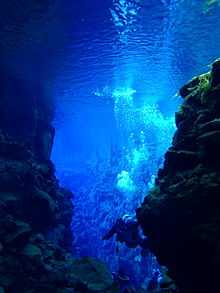
Silfra, by virtue of its location in the Þingvallavatn Lake, contains clear, cold water that attracts scuba divers drawn to its high visibility and geological importance; divers are literally swimming between continents. The rift claims a shallow depth nearest to the bank, but deepens and widens further out.[8][9][10]
Scuba diving professionals have divided Silfra into three sections: Silfra hall, Silfra cathedral and Silfra lagoon. At its deepest, Silfra is 63 metres deep but diving this depth is seldom done and only by appropriately qualified advanced divers. In any case the most wondrous sights are in Silfra cathedral which is a 100 meter long fissure where you can see from end to end.[11]
The rift offers amazing visibility and has been placed on the world's top 50 diving destinations by at least one travel site.[12] The visibility reaches 70–80 meters. Diving tour operators however make exaggerated claims of 150 to 300 meters.[13]
See also
- Þingvellir
- Þingvallavatn
- Scuba diving
- Langjökull
- Skjaldbreiður
- Geography of Iceland
- List of lakes of Iceland
- List of glaciers
- Sport in Iceland
References
- ↑ Geology of Silfra, Silfra.org - website
- ↑ Water in Silfra, Silfra.org - website
- ↑ Geology of Silfra, Silfra.org - website
- ↑ Silfra Caves, Silfra.org - website
- ↑ Water in Silfra, Silfra.org - website
- ↑ Top Diving Destination, Dive Iceland
- ↑ Video of Diving Silfra, Diving Video of Silfra
- ↑ Detailed information and photos of Silfra, Silfra.org - website
- ↑ Diving, Þingvellir National Park website
- ↑ Detailed description of Silfra, DIVE.IS website
- ↑ Three sections of Silfra, Total Iceland
- ↑ Into the deep: World’s 50 best dive sites, CNN Travel
- ↑ Top Diving Destination, Dive Iceland