Silchar
| Silchar শিলচর | |
|---|---|
| city | |
|
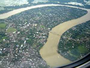
Aerial view of the Barak river, Silchar | |
 Silchar Location in Assam, India | |
| Coordinates: 24°49′N 92°48′E / 24.82°N 92.8°ECoordinates: 24°49′N 92°48′E / 24.82°N 92.8°E | |
| Country | India |
| State | Assam |
| District | Cachar |
| Government | |
| • Body | Silchar Municipality Board |
| • No. of Wards | 28 |
| Elevation | 22 m (72 ft) |
| Population (2011) | |
| • Total | 228,985 |
| • Rank | 2 (in Assam after Guwahati ) |
| Languages | |
| • Official | Bengali |
| Time zone | IST (UTC+5:30) |
| PIN | 7880xx |
| Telephone code | 91 (0) 3842 |
| Vehicle registration | AS-11 |
| Website |
www |
Silchar (/ˈsɪlˌʧə/ or /ˈʃɪlˌʧə/) (Bengali: শিলচর Shilchôr) is the headquarters of Cachar district in the state of Assam in India. It is 343 kilometres (213 mi) south east of Guwahati. It is the second-largest town of the state in terms of population and municipal area.[1]
Being politically stable in the otherwise disturbed Northeast earned it the bon mot of "Island of Peace" from India's then Prime Minister Indira Gandhi.[2]
Approximately 90% residents of Silchar are Bengalis who speak the Sylheti dialect, the rest being Bihari people, Bishnupriya Manipuri, Dimasa Kachari (Barman), Manipuri (Meitei), Marwaris, Assamese and some tribal groups like Nagas. Silchar is situated by the banks of the Barak River in what is popularly known as Barak Valley. Rice is the staple cereal. Fish is also widely consumed. Shuţki (the local name for dried fish), shidal chutney and chunga-r peetha are some of the local delicacies.
Etymology
During the British rule, ships were docked at the bank of the river Barak. Gradually, a market developed at the bank and became a major place of economic activity. The bank was covered with stones to help dock ships and vessels, and the market was developed at a place that was fully covered with stones. People started to refer to the place as Shiler Chor, meaning "a bank of stones". With the passage of time, Shiler Chor was simplified to Silchar, and ultimately the British officials started to use the name Silchar in their official documents referring to the surrounding area of the market. Thus Silchar became the official name of the place.[3]
History
Cachar district records
In the 1850s, British tea planters re-discovered the game polo in Manipur on the Burmese border with India. The first polo club in the world was formed at Silchar. The first competitive modern form of polo was played in Silchar, the plaque for this feat still stands behind the District Library, Silchar.
Railway link
The Assam Bengal Railway brought Silchar into the Indian railway map in 1899. The railway line from Lumding to Silchar is hailed as one of the most exciting pristine railway tracks of India. Built by the British during the colonial rule, the meter gauge line stands testimony to the grandiose of what was once a highly popular city in the North-East is now converted to Broad Gauge.
Language martyrs

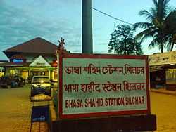
Silchar saw one of the uprisings in favour of the Bengali language. When the Assam government, under Chief Minister Bimala Prasad Chaliha, passed a circular to make Assamese mandatory, Bengalis of Barak Valley protested. On 19 May 1961, when Assam police opened fire on unarmed protesters at Silchar Railway Station, 11 agitators died. After the popular revolt, the Assam government had to withdraw the circular and Bengali was ultimately given official status in the three districts of Barak Valley.[4][5]
Economy
Over the past few years, the town has seen an influx of people from nearby States and places due to the Silchar's increasing prospects and other developments in the field of education , medical facilities etc. making the town quite over-crowded.
Geography
Silchar is located in the southern part of Assam.[6][7] Situated on the banks of the Barak River, it is a trade and processing centre for tea, rice and other agricultural products. There is limited industry, principally papermaking and tea-box manufacturing. The city has an airport and is connecting to Guwahati, Agartala, Imphal, and Aizawl. Silchar is regarded as an important road junction of the North Eastern India and serves as a major point of connection for Tripura, Manipur and Mizoram.
The area of Silchar town is 15.75 km2. It has an average elevation of 22 meters (72 feet).
Demographics
As of 2011 India census, Silchar had a population of 178,865.[8] Total number of males were 89,961 and females 88,904. The sex ratio of Silchar was 988 females per 1000 males, which is above the national ratio of 940 females per 1000 males. Silchar has an average literacy rate of 91.74%, higher than the national average of 59.5%, with male literacy of 93.97% and female literacy at 89.50%. Major religions followed are Hinduism, Islam, Christianity and Jainism. There are also a small community of Sikhs residing in the town.
Climate
At Silchar, the climate is tropical by nature. The wind generally blows from the northeast in the morning and from the southeast in the afternoon. Summer is hot, humid and interspersed with heavy rainfall and thunderstorms. Winter generally starts towards the end of November and lasts till February. Towards the start of the Bengali month of Baishakh (mid-April) rain clouds start covering the skyline. Silchar is inundated frequently due to excessive rainfall and floods by the River Barak. In the last three decades, Silchar and the Barak Valley have been ravaged by four major floods - one in 1986, followed by the ones in 1991, 2004 and 2007.
| Climate data for Silchar (1971–2000) | |||||||||||||
|---|---|---|---|---|---|---|---|---|---|---|---|---|---|
| Month | Jan | Feb | Mar | Apr | May | Jun | Jul | Aug | Sep | Oct | Nov | Dec | Year |
| Record high °C (°F) | 31.0 (87.8) |
35.0 (95) |
37.8 (100) |
39.4 (102.9) |
39.1 (102.4) |
37.9 (100.2) |
39.4 (102.9) |
39.0 (102.2) |
38.3 (100.9) |
36.7 (98.1) |
35.0 (95) |
31.7 (89.1) |
39.4 (102.9) |
| Average high °C (°F) | 24.5 (76.1) |
26.4 (79.5) |
29.6 (85.3) |
30.5 (86.9) |
31.0 (87.8) |
31.5 (88.7) |
31.4 (88.5) |
31.9 (89.4) |
31.5 (88.7) |
30.9 (87.6) |
29.1 (84.4) |
26.1 (79) |
29.6 (85.3) |
| Average low °C (°F) | 12.1 (53.8) |
14.1 (57.4) |
17.7 (63.9) |
21.0 (69.8) |
23.0 (73.4) |
24.6 (76.3) |
25.1 (77.2) |
25.2 (77.4) |
24.6 (76.3) |
22.9 (73.2) |
18.6 (65.5) |
13.9 (57) |
20.4 (68.7) |
| Record low °C (°F) | 5.6 (42.1) |
5.0 (41) |
8.3 (46.9) |
13.2 (55.8) |
15.6 (60.1) |
19.3 (66.7) |
19.0 (66.2) |
19.4 (66.9) |
16.8 (62.2) |
14.4 (57.9) |
10.6 (51.1) |
6.1 (43) |
5.0 (41) |
| Average precipitation mm (inches) | 12.1 (0.476) |
44.2 (1.74) |
229.3 (9.028) |
258.1 (10.161) |
460.7 (18.138) |
612.0 (24.094) |
503.2 (19.811) |
427.7 (16.839) |
366.5 (14.429) |
168.7 (6.642) |
33.3 (1.311) |
12.8 (0.504) |
3,128.6 (123.173) |
| Avg. rainy days | 1.0 | 3.9 | 8.5 | 12.6 | 16.2 | 21.5 | 22.5 | 19.3 | 15.5 | 7.7 | 2.4 | 0.6 | 131.6 |
| Source: India Meteorological Department (record high and low up to 2010)[9][10] | |||||||||||||
Education
The schools of Silchar are run by the state government and private organisations. Bengali and English are the primary languages of instruction; Assamese and Hindi are also used. The schools are affiliated to either Secondary Board of Education, Assam and the CBSE. Prominent schools of Silchar include:- Silchar Collegiate School, Holy Cross Higher Secondary School, Don Bosco School, Adhar Chand Higher Secondary School,Cachar High School, Muktashree High School, South Point School, Narsing Higher Secondary School, Govt. Boys & Girls Higher Secondary Schools, Maharshi Vidya Mandir, Dinanath Navakishore Higher Secondary School, Chhotelal Seth High School, Four Kendriya Vidyalayas, Oriental High School etc.
Silchar is home to the main campus of Assam University, a central university, which imparts education in both the general as well as professional streams. The university, which came into existence in 1994, has 16 schools and 35 post-graduate departments under them. The university has 56 affiliated colleges under it.[11][12]
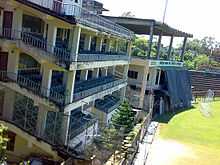
The colleges in Silchar are mostly affiliated with the Assam university. National Institute of Technology, Silchar is one of the oldest engineering colleges in the region. Prominent colleges in Silchar include Guru Charan College, Cachar College, Women's College, Radhamadhab College, Silchar College,[13] Ramanuj Gupta Junior College, Hemangini Dey memorial Jr. College etc. Silchar Medical College and Hospital, established in 1968, serves the southern region of Assam. There is an Institute of Pharmacy attached to it.[14] Silchar also has a polytechnic college Silchar Polytechnic, which offers Diploma in Engineering programs.Distance Education Provided By Sikkim Manipal University, Silchar.
Apart from these, Silchar also has a B.Ed College, Law College and an Industrial Training Center.
Connectivity
Silchar is connected by road, railways and air to the rest of the country.
Railways

Silchar Railway station falls under the juriadiction of the North East Frontier Railway zone of the Indian Railways. The railway gauge functioned here is Indian Gauge. The railway station is situated in Tarapur, Silchar. The Indian Gauge conversion which includes the reconstruction of the railway station has been started from 1st October,2014 onwards as a part of the Lumding - Badarpur - Silchar railway section of the North East Frontier Railways of the Indian Railways. The project is completed and opened for goods train. The date of opening goods train service is 27th March 2015. Soon it is expected to be opened for passenger services after CRS inspection.
Roadways
Regular bus services connect Silchar with Guwahati, Shillong, Aizawl, Agartala and Imphal through NH 37 and NH 53. However during the rainy seasons, heavy downpour affects the Silchar-Shillong-Guwahati route causing frequent landslides which affects the road transportation. There is an Inter State Bus and an Inter State Truck Terminus which was constructed in the year 2005. The under construction four lane East - West corridor will connect Silchar in the east with Saurashtra in the west.
Air connectivity
The airport is located at Kumbhirgram, about 22 km from Silchar and there are regular flights connecting Silchar with Kolkata, Guwahati& Tezpur. The airport is being modernised and is considered the fourth-busiest in north eastern India after Guwahati, Imphal and Agartala in terms of flight movements.[15] Silchar has been selected as one of the towns for the construction of 51 low cost airports across the country recently.[16]
In December 1985, Air India operated the first all-woman crew flight in the world from Kolkata to Silchar which was commanded by Captain Saudamini Deshmukh on a Fokker F-27 Friendship aircraft.[17]
Politics
Silchar is part of the Silchar (Lok Sabha constituency). The current member of Parliament from Silchar is Sushmita Dev who is the youngest daughter of the veteran politician Santosh Mohan Dev of the Indian National Congress.[18]
Sports facilities
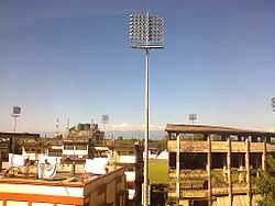
Satindra Mohan Dev Stadium is the only multipurpose stadium located at Silchar. The stadium has hosted an international one day match between the Indian and the England women's teams. It has also hosted Ranji Trophy and Duleep Trophy matches. Among the major football competitions, Santosh Trophy and I-League 2nd Division matches have been hosted at the ground.
Silchar also has an Indoor Stadium which is also used mainly for indoor sports.

The Tennis Club, Silchar is the only facility for hosting tennis matches and has multiple synthetic courts. The club also has an academy for imparting training.
Media
Silchar has an All India Radio station known as Akashvani Silchar. It broadcasts on AM and FM frequencies. Silchar also has a terrestrial television transmission center and studio of India's national broadcaster Doordarshan, known as DD Silchar.
In the print media, a number of Bengali and English daily newspapers are published from the town. The major newspapers published from Silchar include Bengali dailies Dainik Jugasankha, Dainik Abichar, Dainik Prantajyoti, Samayik Prasanga, Janakantha and the English dailies The Sentinel and Eastern Chronicle. Besides the local newspapers, national and regional dailies like The Telegraph, Anandabazar Patrika, The Times of India, The Statesman, The Assam Tribune etc. are also available.
Tourist attractions
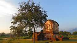
- Khaspur: 20 km from Silchar stands the ruin of a great Dimasa kingdom, capital of historical time and importance. Khaspur was the capital of the Dimasa Kachari Kings and its construction was completed in 1690 AD. The main attractions are the Lion Gate, the Sun Gate and age-old kings temple. The original palace is non-existent, but its subsidiaries, the main entrance gate, the Suryadwar, Debalaya are intact. The entrances are of elephant-patterns.
- Bhubaneshwar Temple is the most celebrated temple of Lord Shiva in the entire South Assam. The Bhubaneshwar temple is about 50 km from Silchar and is on the top the Bhuvan hill. This is a place of pilgrimage and during the festival of Shivaratri, thousand of Shivayats march towards the hilltop to worship Lord Shiva. This temple by its geography attracts a lot of hikers as there are no motor roads to reach the hilltop. One has to hike at least 17 km from the plains to the temple.
- Iskcon Temple is an important temple dedicated mainly to Lord Krishna. The temple is in Ambikapatty, Silchar. It was built and is being operated by the world famous Sanatan Dharmic spiritual organization ISKCON. There is a vegetarian restaurant operated nearby by the organization ISKCON.
- Kancha Kanti Kali Temple: 11 km from Silchar stands the historical and most celebrated temple of South Assam, i.e., the temple of Mother Goddess “Kachakanti”. She is said to be amalgamation of two powerful Hindu deities: mother Durga and mother Kali. The original temple was built in 1806 AD by the Kachari king. Human sacrifices were offered to the Goddess till 1818 AD. The old temple is ruined now and has been replaced by new temple which was built in 1978.
- Gandhibag Park is in Park Road, at the center of the town. The park is named after Mahatma Ganadhi. There is a Shahid Minar in the park dedicated to the language martyrs who sacrificed their lives on 19 May 1962 fighting for the protection of the Bengali language against the Government of Assam.
- Maniharan Tunnel is a popular pilgrim spot about 5 km from Bhubaneswar temple. As per legends, this tunnel was once used by Lord Krishna. The holy River Tribeni flows beneath this tunnel. Maniharan temple, dedicated to Lord Krishna, is on the premises.
Notable people
- Arun Kumar Chanda
- Ullaskar Dutta
- Santosh Mohan Dev
- Kabindra Purkayastha
- Debojit Saha
- B. B. Bhattacharya
Gallery
-

View of the ceiling from inside Goldighi Mall
-
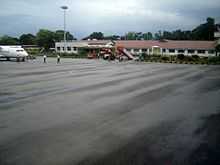
Silchar Airport, August 2007, on a rainy day with 1000m visibility
See also
References
- ↑ "Indian cities with population of 1 lakh and above" (PDF). Census India. Govt. of India. Retrieved 21 February 2014.
- ↑ "APCC member for nomination of Gaurav Gogoi from Barak Valley". The Sentinel, Assam. 6 June 2012. Retrieved 4 July 2012.
- ↑ "Silchar (India) - Britannica Online Encyclopedia". Britannica.com. Retrieved 2012-08-17.
- ↑ "No alliance with BJP, says AGP chief". The Telegraph, Calcutta. 27 December 2003. Retrieved 3 March 2014.
- ↑ "Silchar rly station to be renamed soon". The Times of India. 9 Jun 2009. Retrieved 3 March 2014.
- ↑ "Location of Silchar". Wikimapia Foundation. Wikimapia. Retrieved 3 March 2014.
- ↑ "Silchar, India Page". Falling Rain Genomics, Inc. Falling Rain Genomics, Inc. Retrieved 3 March 2014.
- ↑ "Census of India". Govt. of India. Government of India. Retrieved 20 February 2014.
- ↑ "Silchar Climatological Table Period: 1971–2000". India Meteorological Department. Retrieved April 27, 2015.
- ↑ "Ever recorded Maximum and minimum temperatures up to 2010" (PDF). India Meteorological Department. Retrieved April 27, 2015.
- ↑ "Assam University, Homepage". Assam University. Retrieved 20 February 2014.
- ↑ "Statistical Data Fact Sheet of AUS" (PDF). Assam University. Assam University. Retrieved 20 February 2014.
- ↑ http://www.dheassam.gov.in/circulars-1/meeting%2057.pdf retrieved on 14th January, 2015
- ↑ "Silchar Medical College, Home Page". Silchar Medical College. Silchar Medical College. Retrieved 20 February 2014.
- ↑ "TRAFFIC STATISTICS - DOMESTIC AIRCRAFT MOVEMENTS" (PDF). Retrieved 2012-08-28.
- ↑ "51 new low-cost airports to be set up: PMO". Daily News & Analysis. 28 June 2013. Retrieved 3 March 2014.
- ↑ Times of India, Online Edition
- ↑ "List of Parliamentary & Assembly Constituencies" (PDF). Assam. Election Commission of India. Retrieved 2008-10-05.
External links
| Wikimedia Commons has media related to Silchar. |
- Official governmental site of Silchar
- NIT, Silchar
- Assam University, Silchar
- Guru Charan College, Silchar
- Cachar College, Silchar
- Silchar Medical College & Hospital, Silchar
- Radhamadhab College, Silchar
- Silchartoday.com