Sierra de la Laguna
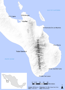
The Sierra de la Laguna is a mountain range on the Baja California Peninsula of Mexico. It lies at the southern end of the peninsula in the state of Baja California Sur, and is the southernmost range of the Peninsular Ranges.
The southern tip of the peninsula, including the Sierra de la Laguna, was formerly an island, and it has a distinctive flora and fauna, with many affinities to southern Mexico. The Sierra is home to many endemic species and subspecies. The dry San Lucan xeric scrub extends from the coast to 250 meters elevation. The Sierra de la Laguna dry forests occupy lower portion of the range, from 250 to 800 meters elevation. Above 800 meters elevation, the dry forests transition to the Sierra de la Laguna pine-oak forests. The composition of the pine-oak forests varies with elevation; oak woodlands predominate from 800 to 1200 meters elevation, with oak-pine woodlands between 1200 and 1600 meters elevation, transitioning to pine-oak forests above 1600 meters elevation. The predominant pine is a local subspecies of Mexican Pinyon, Pinus cembroides subsp. lagunae.
The forests are exploited commercially for timber, and cattle-raising is common in the oak woodland and dry forest zones.
UNESCO has designated the Sierra de la Laguna a global biosphere reserve: "This semi arid to temperate subhumid climate area represents highly important and contrasted ecosystems, including arid zones, matorrales, low deciduous forest type, evergreen oak: Quercus devia (“encino”) woods, pine-evergreen oak mix woods and oases with palms and “guerivos” situated throughout the gallery forest following the long river basins." The Biosphere reserve was established by a Mexican presidential decree of 6 June 1994, which designated a core area and buffer zones. The core area is centered on the higher-elevation oak-pine forests, while the transition area includes the communities of Todos Santos, El Pescadero, El Triunfo, San Antonio, San Bartolo, Buena Vista, Los Barriles, Las Cuevas, Santiago and Miraflores.
Climate
The climate is influenced by its altitude. At higher altitudes, it has a subtropical highland climate with cool temperatures year round and higher amounts of precipitation.
| Climate data for Sierra de la Laguna, elev. 1,906 metres (6,253 ft) | |||||||||||||
|---|---|---|---|---|---|---|---|---|---|---|---|---|---|
| Month | Jan | Feb | Mar | Apr | May | Jun | Jul | Aug | Sep | Oct | Nov | Dec | Year |
| Record high °C (°F) | 25.0 (77) |
26.0 (78.8) |
29.5 (85.1) |
29.0 (84.2) |
32.5 (90.5) |
34.0 (93.2) |
31.0 (87.8) |
36.0 (96.8) |
33.0 (91.4) |
31.0 (87.8) |
29.0 (84.2) |
30.0 (86) |
36.0 (96.8) |
| Average high °C (°F) | 15.8 (60.4) |
17.2 (63) |
19.0 (66.2) |
21.1 (70) |
22.7 (72.9) |
24.4 (75.9) |
23.8 (74.8) |
22.9 (73.2) |
22.4 (72.3) |
21.2 (70.2) |
19.0 (66.2) |
17.4 (63.3) |
20.6 (69.1) |
| Daily mean °C (°F) | 8.9 (48) |
9.7 (49.5) |
11.2 (52.2) |
13.4 (56.1) |
15.2 (59.4) |
17.8 (64) |
18.3 (64.9) |
17.6 (63.7) |
17.1 (62.8) |
15.0 (59) |
12.0 (53.6) |
10.2 (50.4) |
13.9 (57) |
| Average low °C (°F) | 2.1 (35.8) |
2.3 (36.1) |
3.4 (38.1) |
5.7 (42.3) |
7.7 (45.9) |
11.3 (52.3) |
12.9 (55.2) |
12.4 (54.3) |
11.8 (53.2) |
8.8 (47.8) |
5.1 (41.2) |
3.1 (37.6) |
7.2 (45) |
| Record low °C (°F) | −7.0 (19.4) |
−7.0 (19.4) |
−6.0 (21.2) |
−4.0 (24.8) |
−1.0 (30.2) |
1.0 (33.8) |
7.0 (44.6) |
5.0 (41) |
4.5 (40.1) |
−2.0 (28.4) |
−6.0 (21.2) |
−6.0 (21.2) |
−7.0 (19.4) |
| Average precipitation mm (inches) | 31.1 (1.224) |
10.2 (0.402) |
6.1 (0.24) |
3.0 (0.118) |
0.2 (0.008) |
7.6 (0.299) |
110.8 (4.362) |
181.7 (7.154) |
166.6 (6.559) |
72.4 (2.85) |
18.5 (0.728) |
39.5 (1.555) |
647.7 (25.5) |
| Avg. precipitation days (≥ 0.1 mm) | 1.92 | 1.32 | 0.78 | 0.37 | 0.18 | 0.90 | 7.62 | 11.91 | 9.45 | 4.65 | 1.86 | 2.60 | 43.56 |
| Avg. snowy days | 0 | 0.04 | 0 | 0 | 0 | 0 | 0 | 0 | 0 | 0 | 0 | 0 | 0.04 |
| Source #1: Colegio de Postgraduados[1] | |||||||||||||
| Source #2: Servicio Meteorológico National (extremes)[2] | |||||||||||||
References
- ↑ "Normales climatológicas para Sierra de la Laguna, B.C.S" (in Spanish). Colegio de Postgraduados. Retrieved January 17, 2013.
- ↑ "NORMALES CLIMATOLÓGICAS 1951-2010" (in Spanish). Servicio Meteorológico National. Retrieved January 17, 2013.