Sierra de San Just
| Sierra de San Just | |
|---|---|
|
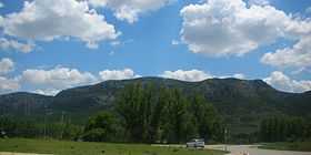
Western end of Sierra de San Just near Montalbán | |
| Highest point | |
| Peak | San Just |
| Elevation | 1,522 m (4,993 ft) |
| Coordinates | 40°44′36″N 0°39′46″W / 40.74333°N 0.66278°WCoordinates: 40°44′36″N 0°39′46″W / 40.74333°N 0.66278°W |
| Geography | |
|
<div style="padding:2px 2px 5px 2px;>  Location in Spain | |
| Location | Cuencas Mineras, Aragon |
| Parent range | Iberian System, Eastern zone |
| Geology | |
| Orogeny | Alpine orogeny |
| Period | Cretaceous |
Sierra de San Just (Aragonese: Sierra de Sant Chust) is a mountain range in the Cuencas Mineras comarca of Aragon, Teruel Province, Spain. The highest point in the range is San Just (1,522 m). This range is located in one of the coldest and most rugged regions of Aragon.[1]
Geography
Landslides are relatively frequent in the San Just mountains.[2]
Besides the mountain ranges, the Plains of Visiedo (Spanish: Llanos de Visiedo) near Visiedo, the Altos del Zancado, and the area surrounding Ejulve, are all part of the Sierra de San Just geographic zone.[3]
Road N-211 crosses the range at Gargallo and skirts the mountainsides of the chain.
Mining
There are lignite deposits in the Sierra de San Just range. The Utrillas mines were exploited since ancient Roman times.[4]
See also
References
- ↑ Gran Enciclopedia Aragonesa - Sierra de San Just
- ↑ Angel Luis Cortés Gracia, Adolfo Maestro González, Los deslizamientos de la sierra de San Just, Instituto de Estudios Turolenses, 1998
- ↑ Gran Enciclopedia Aragonesa - Zancado, altos del
- ↑ Cañada Vellida - Sierra de Sant Just
External links
| Wikimedia Commons has media related to Sierra de San Just. |
- Geografia de la Provincia de Teruel
- Region of Cuencas Mineras
- Paragliding - Sierra de San Just
- Utrillas - Historia
- Gargallo, en la Sierra de Sant Just
- Cuencas Mineras - Tourism (Spanish)
| ||||||||||||||||||||||