Siem Reap
| Siem Reap ក្រុងសៀមរាប | |
|---|---|
| City | |
|
Siem Reap, town and river | |
| Nickname(s): Great Gate to Angkor | |
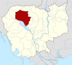
 Siem Reap Location of Siem Reap, Cambodia | |
| Coordinates: 13°21′44″N 103°51′35″E / 13.36222°N 103.85972°E | |
| Country |
|
| Province | Siem Reap |
| Settled | 802 |
| Official | 1907 |
| Government | |
| • District Chief & Governor | Khim Bunsong (CPP) |
| • Deputy Governor | Kim Chay Hieng (CPP) |
| Elevation | 18 m (59 ft) |
| Population (2008)[1] | |
| • Total | 174,265 |
| Time zone | Cambodia (UTC+7) |

Siem Reap (Khmer: ក្រុងសៀមរាប, pronounced [siəm riəp]; Thai: เสียมราฐ) is the capital city of Siem Reap Province in northwestern Cambodia, and a popular resort town as the gateway to Angkor region.
Siem Reap has colonial and Chinese-style architecture in the Old French Quarter, and around the Old Market. In the city, there are museums, traditional Apsara dance performances, Cambodian cultural village, souvenir and handycraft shops, silk farms, rice-paddy countryside, fishing villages and a bird sanctuary near the Tonle Sap Lake.
Siem Reap today—being a popular tourist destination—has a large number of hotels, resorts, restaurants and businesses closely related to tourism. This is much owed to its proximity to Angkor temples, the most popular tourist attraction in Cambodia.
History

The name Siem Reap can be translated to mean 'Defeat of Siam' (Cambodians call Thailand Siam or “Siem”), and it refers to the centuries-old conflict between the Siamese and Khmer peoples. Under the rule of the Ayutthaya Kingdom in the 18th century, it was referred to as Nakhom Siam.[2] According to oral tradition, the name was given by King Ang Chan (1516–1566) as “Siem Reap”, meaning “the flat defeat of Siam” after he defeated the Thai King Maha Chakkraphat who sent an army to attack Cambodia in 1549.[3] Scholars however consider this a modern folk etymology and that the actual origin of the name of Siem Reap is unknown.[4]
The story was told that King Ang Chan of Cambodia tried to assert further independence from Siam. The Siamese also had been through internal trouble themselves during these years. King Chairacha was poisoned by his concubine, Lady Sri Sudachan, who committed adultery with a commoner, Worawongsathirat, while he was on a campaign against Chiang Mai. Sudachan then raised Worawongsathirat to the throne. The nobles hated Worawongsathirat and lured the usurper and his family to a place outside the city where he was assassinated, together with Sudachan and a new-born daughter, during the royal family's procession by barge to see a white elephant (allegedly just captured). The nobles then invited Prince Thianracha, who was a monk in a monastery, to give up that role and ascend the throne under the title of King Maha Chakkraphat (1548–1569). Being informed of the internal troubles in Ayutthaya, King Ang Chan attacked Prachin Buri in 1549 and successfully took away its Siamese inhabitants. There he obtained information that of Maha Chakkraphat's coronation, signaling that the question of succession in Ayutthaya had thus been settled. Ang Chan therefore retreated and did not advance any further. King Maha Chakkraphat was very angry at this, but his hands were tied, because the Burmese had just come by way of the Three Pagodas Pass; they took Kanchanaburi and Suphanburi, and appeared in front of Ayutthaya.

Because King Ang Chan refused to give King Maha Chakkraphat a white elephant when he asked for it, it is indicated that Ang Chan declined any symbol of vassalage to Siam. Maha Chakkraphat's attention was now turned towards Cambodia.[5] He put Prince Ong, the governor of Sawankhalok and Srey’s son, in charge of an expedition against Cambodia. Ang Chan counter-attacked, and shot Prince Ong dead on an elephant’s back, and his army routed the Siamese and captured no less than 10,000 Siamese troops. It was because of this victory over Siamese the that King Ang Chan renamed the battleground as “Siem Reap” meaning “the flat defeat of Siam”.

However, most sources indicate the decline of Angkor more than a century prior, when an Ayutthaya military expedition captured and sacked Angkor Wat in 1431, initiating a period of vassal rule there.[6] This event coincided with the decline of the city, though there is not a full understanding of the reasons behind the abandonment of Angkor Wat, which may have included changes in the environment and failings of infrastructure.[7]
From the sixteenth through to the nineteenth centuries, the feuds among the Khmer lords caused the interventions and domination from their more powerful neighbors: Vietnam and Siam. Siem Reap, along with Battambang (Phra Tabong) and Sisophon, major cities in the north western part of Cambodia, were under Siamese administration known as Inner Cambodia from 1795 till 1907 when the province was ceded to French Indochina.
Re-discovery of Angkor

Siem Reap was little more than a village when French explorers such as Henri Mouhot "re-discovered" Angkor in the 19th century. Western visitors however have visited the temple much earlier, for example António da Madalena in 1586".[8] In 1901 the École française d'Extrême-Orient (EFEO; French School of the Far East) began a long association with Angkor by funding an expedition into Siam to the Bayon. The EFEO took responsibility for clearing and restoring the whole site. In the same year, the first tourists arrived in Angkor – an unprecedented 200 of them in three months. Angkor had been 'rescued' from the jungle and was assuming its place in the modern world.
With the acquisition of Angkor by the French in 1907 due to the Franco-Siamese agreement, Siem Reap began to grow, absorbing the first wave of tourists. The Grand Hotel d'Angkor opened its doors in 1929 and the temples of Angkor remained one of Asia's leading draws until the late 1960s, luring visitors like Charlie Chaplin and Jackie Kennedy. In 1975, the population of Siem Reap, along with that of the rest of the cities and towns in Cambodia, was evacuated by the communist Khmer Rouge and driven into the countryside.
As with the rest of the country, Siem Reap's history (and the memories of its people) is coloured by the spectre of the brutal Khmer Rouge Regime, though since Pol Pot's death in 1998, relative stability and a rejuvenated tourist industry have been important steps in an important, if tentative, journey forward to recovery. With the advent of war, Siem Reap entered a long slumber from which it only began to awake in the mid-1990s.

Today, Siem Reap serves as a small gateway town to the world famous heritage site of the Angkor temples. Thanks to those attractions, Siem Reap has transformed itself into a major tourist hub. Siem Reap nowadays is a vibrant town with modern hotels and architectural styles. Despite international influences, Siem Reap and its people have conserved much of the town's image, culture and traditions.
Siem Reap, the developing resort town near the Angkor Wat temple complex in Cambodia ranks 4th based on the World's Best Cities of Travel + Leisure survey 2014.
The Wat and the river

The Town is a cluster of small villages along the Siem Reap River. These villages were originally developed around Buddhist pagodas (Wat) which are almost evenly spaced along the river from Wat Preah En Kau Sei in the north to Wat Phnom Krom in the south, where the Siem Reap River meets the great Tonle Sap Lake.
The main town is concentrated around Sivutha Street and the Psar Chas area (Old Market area) where there are old colonial buildings, shopping and commercial districts. The Wat Bo area is now full of guesthouses and restaurants while the Psar Leu area is often crowded with jewellery and handicraft shops, selling rubies to woodcarving. Other fast developing areas are the airport road and main road to Angkor where a number of large hotels and resorts can be found.
Economy

Businesses centered on tourism have flourished due to the tourism boom. There is a wide range of hotels, ranging from several 5-star hotels and chic resorts to hundreds of budget guesthouses. Plenty of shopping opportunities exist around the Psar Chas area while the nightlife is often vibrant with a number of western-styled pubs and bars.
Most tourists come to Siem Reap to visit the Angkor Wat, Angkor Thom, (about 6 km north of the city), and other Angkor ruins.
The Gecko Environment Center is a floating environment center located in the province of Siem Reap on the Tonle Sap Lake. The goal of the center is to promote environmental awareness among the local community as well as visitors to the great lake.[9] The province of Siem Reap is part of the Tonle Sap Biosphere Reserve.ot
There are also a large number of NGOs and other not-for profits that operate in and around Siem Reap, and play a vital role in the economy, as well as helping to develop it for the future. Thousands of expatriates call the city home and also significantly impact the economy.
Attractions
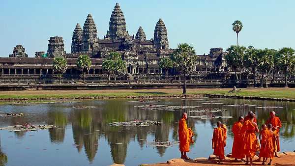
Angkor Wat
Angkor Wat (Wat temple) is the central feature of the Angkor UNESCO World Heritage Site containing the magnificent remains of the Khmer civilization. Angkor Wat's rising series of five towers culminates in an impressive central tower that symbolizes mythical Mount Meru. Thousands of feet of wall space are covered with intricate carving depicting scenes from Hindu mythology.
Angkor Thom
.jpg)
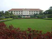
This magnificent inner royal city was built by the end of the 12th century and is renowned for its temples, in particular the Bayon. Other notable sites are Baphuon, Phimeanakas, The Terrace of the Elephants and The Terrace of the Leper King. The city can be accessed through 5 city gates, one on each cardinal point and the Victory Gate on the eastern wall.
Other temples
A number of significant temples are dotted near Angkor Wat and Angkor Thom within the Angkor Archaeological Park, including Ta Prohm, Preah Khan, Banteay Kdei, Phnom Bakheng, Ta Keo, Ta Som, East Mebon, Pre Rup and Neak Pean. These temples may be visited along the grand circuit or the small circuit routes.[10] Other sites are the Roluos group of temples to the east of Siem Reap.
War Museum Cambodia
The War Museum Cambodia covers the last three decades of the 20th century when the Khmer Rouge was active in Cambodia. There is a vast array of vehicles, artillery, weaponry, landmines and equipment on display. The museum is making use of guides whom are war veterans who fought for the Cambodian army, the Khmer Rouge or the Vietnamese army.

Angkor National Museum
Opened on 12 November 2007, the Angkor National Museum offers visitors a better understanding of the area's archaeological treasures. The Golden Era of the Khmer Kingdom is presented, including the use of state-of-the-art multimedia technology. The museum covers Khmer history, civilization, and cultural heritage in eight galleries.[11]
Old Market

This market offers a mixture of souvenirs for tourist and a variety of food produce and other items meant for the locals.
Cambodian Cultural Village
Opened on September 24, 2003, the Cambodian Cultural Village assembles all the miniatures of famous historical buildings and structures of Cambodia. There are 11 unique villages, which represent different culture heritages, local customs and characteristics of 21 multi races.
Artisans Angkor
Artisans Angkor is a semi-public company founded in 1992 which aims to revive traditional Khmer craftsmanship and provide employment for rural artisans. It is also associated with a silk farm where visitors may learn about sericulture and weaving.[12]
Notable sites near Siem Reap
_(6824988525).jpg)
A number of notable sites further away from Siem Reap are also accessible from the town.
Phnom Kulen
The Phnom Kulen National Park is about 48 km from Siem Reap and contains a number of attractions such as its two waterfalls and the Kbal Spean's "river of 1000 lingas".

Floating Villages
There are three floating villages around Siem Reap - Kompong Khleang, Kompong Phluk, Chong Kneas, with Kompong Khleang considered the most authentic.[13]
Tonlé Sap
The Tonlé Sap, Khmer for "Vast Body of Fresh Water" and more commonly translated as "Great Lake" is a combined lake and river system of major importance to Cambodia. It is located in the heart of Cambodia about 30 minutes south of downtown Siem Reap and has many attractions.

Phnom Dei
Phnom Dei is a hill near Siem Reap.
Banteay Srei
Banteay Srei is a 10th-century temple located about 30 km northeast of Siem Reap. It is notable for its fine intricate decorative carvings on rose pink sandstone.[14]
Climate
According to the Köppen climate classification, Siem Reap features a tropical wet and dry climate. The city is generally hot throughout the course of the year, with average high temperatures never falling below 30 C in any month. Siem Reap has a relatively lengthy wet season which starts in April and ends in November. The dry season covers the remaining four months. The city averages approximately 1500 mm of rainfall per year.
| Climate data for Siem Reap | |||||||||||||
|---|---|---|---|---|---|---|---|---|---|---|---|---|---|
| Month | Jan | Feb | Mar | Apr | May | Jun | Jul | Aug | Sep | Oct | Nov | Dec | Year |
| Average high °C (°F) | 32.0 (89.6) |
33.3 (91.9) |
34.6 (94.3) |
35.5 (95.9) |
35.2 (95.4) |
33.5 (92.3) |
32.7 (90.9) |
32.0 (89.6) |
32.2 (90) |
31.3 (88.3) |
30.6 (87.1) |
31.0 (87.8) |
32.83 (91.09) |
| Average low °C (°F) | 19.7 (67.5) |
20.8 (69.4) |
26.1 (79) |
25.1 (77.2) |
25.4 (77.7) |
24.8 (76.6) |
24.8 (76.6) |
25.0 (77) |
24.5 (76.1) |
23.9 (75) |
22.4 (72.3) |
20.3 (68.5) |
23.57 (74.41) |
| Average precipitation mm (inches) | 0.7 (0.028) |
3.5 (0.138) |
28.0 (1.102) |
61.2 (2.409) |
175.9 (6.925) |
221.3 (8.713) |
236.6 (9.315) |
151.0 (5.945) |
276.1 (10.87) |
248.0 (9.764) |
81.7 (3.217) |
10.1 (0.398) |
1,494.1 (58.824) |
| Source: worldweather.org [15] | |||||||||||||
Transportation

The town is 7 km from the Siem Reap-Angkor International Airport (IATA code REP). Siem Reap is accessible by direct flights from many Asian cities, and by land from Phnom Penh and the Thai border. It’s also accessible by boat (via the Tonle Sap lake) and bus from Phnom Penh and Battambang. A new airport is planned 60 km from Siem Reap.[16]
It is possible to get from Bangkok to Siem Reap via Poipet. The road from Poipet to Siem Reap is newly paved and sealed as of 2013. If travelers take a taxi from Bangkok to Poipet and from Poipet to Siem Reap, it is possible to complete the whole journey in 6–10 hours, depending on border-crossing times. This journey is also possible by bus and minibus.
Sister cities
 Bagan, Myanmar[17]
 Fontainebleau, France, since 11 June 2000
References
- ↑ "2008 Census". Archived from the original on 2013-01-11.
- ↑ Gerald W. Fry; Gayla S. Nieminen; Harold E. Smith (8 August 2013). Historical Dictionary of Thailand. Scarecrow Press. pp. 362–. ISBN 978-0-8108-7525-8.
- ↑ Joachim Schliesinger (2012). Elephants in Thailand Vol 3: White Elephants in Thailand and Neighboring Countries. White Lotus. p. 32. ISBN 978-9744801890.
- ↑ Zhou Daguan (2007). A Record of Cambodia. translated by Peter Harris. University of Washington Press. ISBN 978-9749511244.
- ↑ Paul Spencer Sochaczewski (29 January 2009). The Sultan and the Mermaid Queen: Surprising Asian People, Places and Things that Go Bump in the Night. Editions Didier Millet. pp. 100–. ISBN 978-981-4217-74-3.
- ↑ John Stewart Bowman (13 August 2013). Columbia Chronologies of Asian History and Culture. Columbia University Press. pp. 511–. ISBN 978-0-231-50004-3.
- ↑ Stone, R. (2006). "ARCHAEOLOGY: The End of Angkor". Science 311 (5766): 1364–1368. doi:10.1126/science.311.5766.1364. ISSN 0036-8075.
- ↑ Higham, The Civilization of Angkor pp. 1–2.
- ↑ "?". TSBR.ed.org.
- ↑ "Angkor Temple Guide". Canby Publications.
- ↑ "Angkor National Museum website". Angkornationalmuseum.com. Retrieved 2011-01-31.
- ↑ Walter E. Little (2011). Textile Economies: Power and Value from the Local to the Transnational. AltaMira Press. p. 207-208. ISBN 978-0759120617.
- ↑ "Siem Reap floating villages: What to expect and why we choose to go to Kompong Khleang". Triple Adventure Cambodia.
- ↑ Beverley Palmer. The Rough Guide to Cambodia. Rough Guides. p. 196. ISBN 978-1848368897.
- ↑ "Weather for Siem Reap". worldweather.org. Retrieved 28 Feb 2008.
- ↑ "Cambodia eyes new airport for Siem Reap". Retrieved 2010-09-22.
- ↑ "?". Myanmar.gov.mm.
External links
| Wikimedia Commons has media related to Siem Reap. |
- Official Siem Reap website
 Siem Reap travel guide from Wikivoyage
Coordinates: 13°21′44″N 103°51′35″E / 13.36222°N 103.85972°E
| |||||||||||||||||||||