Shuro-obod District
| Shuro-obod District ناحیه شوراآباد | |
|---|---|
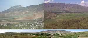 Shuro-obod City. | |
 Shuro-obod District Location in Tajikistan | |
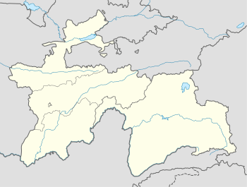 Shuro-obod District ناحیه شوراآباد Shuoobod Шӯрообод Location in Tajikistan | |
| Coordinates: 37°50′24″N 70°2′31″E / 37.84000°N 70.04194°ECoordinates: 37°50′24″N 70°2′31″E / 37.84000°N 70.04194°E | |
| Country |
|
| Province | Khatlon |
| Region | Kulob |
| Capital | Shuro-obod city |
| Area | |
| • Land | 2,380 km2 (920 sq mi) |
| Population (2009) | |
| • Total | 52,200 |
| • Ethnicities |
|
| • Languages | Tajik-Persian |
| Area code(s) | +992,3319 |
Shuro-obod District or Nohiya-i Shuro-obod (Tajik: Ноҳияи Шурообод/Persian: ناحیۀ شورآباد) is a district in Khatlon province, southeastern Tajikistan. Its capital is Shuro-obod City.
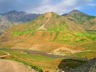
Friendship Bridge between  Afghanistan, and
  Tajikistan, in Khwahan, regions and Shohuni Shuro-obod,پل دوستی میان افغانستان و تاجیکستان, در منتقه خواهان و شورآباد,Пули дусти миёни Афғонистону Тоҷикистон, дар мантиқаи Хвоҳон ва Шуро-обод
.
Geography
Shurobod District bordered by The north, -Darvoz District, -Muminobod District, the West -Kulob District, And the south Hamadoni District, by Districts Khatlon province is. And the east River Panj, And The four-districts of Badakhshan province Afghanistan, -Khwahan, Raghistan, and Yawan, Shahri Buzurg, is. The District has a total area 2,380 square kilometres (920 sq mi) And the located in the Hazrat-i Shoh mountains skirts.
Subdivisions
According Country division the Shuro-obod District 1 town and 7 parts - Jamoats[1] has:
| (Jamoats) Parts of Shuro-obod District [2] | ||||||||||||
| Parts | Population | No. of its villages | ||||||||||
|---|---|---|---|---|---|---|---|---|---|---|---|---|
| Shuro-obod | 8 099 | |||||||||||
| Dashti-Jum | 3 551 | |||||||||||
| Doghistan | 4 818 | |||||||||||
| Yol | 5 029 | |||||||||||
| Langardara | 3 311 | |||||||||||
| Sari Chashma | 9 339 | |||||||||||
| Chagam | 4 546 | |||||||||||
References
- ↑ "List of Jamoats". UN Coordination, Tajikistan. Retrieved March 5, 2011.
- ↑ http://www.undp.tj/files/maps/JCP/Tajik_pdf/Local_Governance/Khatlon/LG4.3.pdf
| ||||||||||||||||
