Shovgenovsky District
| Shovgenovsky District Шовгеновский район (Russian) Шэуджэн район (Adyghe) | |
|---|---|
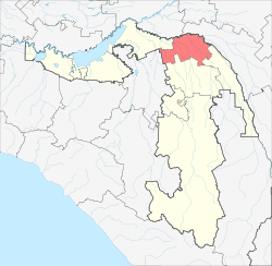 Location of Shovgenovsky District in the Republic of Adygea | |
| Coordinates: 45°01′12″N 40°13′48″E / 45.02000°N 40.23000°ECoordinates: 45°01′12″N 40°13′48″E / 45.02000°N 40.23000°E | |
.png) |
.png) |
|
| |
| Location | |
| Country | Russia |
| Federal subject | Republic of Adygea[1] |
| Administrative structure (as of June 2012) | |
| Administrative center | aul of Khakurinokhabl[1] |
| Inhabited localities: | |
| Rural localities | 31 |
| Municipal structure (as of July 2005) | |
| Municipally incorporated as | Shovgenovsky Municipal District[2] |
| Municipal divisions:[2] | |
| Urban settlements | 0 |
| Rural settlements | 6 |
| Local government: | |
| Head | Nalby Khuazhev |
| Statistics | |
| Area | 521.4 km2 (201.3 sq mi) |
| Population (2010 Census) | 16,997 inhabitants[3] |
| - Urban | 0% |
| - Rural | 100% |
| Density | 32.6/km2 (84/sq mi)[4] |
| Time zone | MSK (UTC+03:00)[5] |
| Established | January 12, 1965 |
| Official website | |
| Shovgenovsky District on WikiCommons | |
Shovgenovsky District (Russian: Шовге́новский райо́н; Adyghe: Шэуджэн район) is an administrative[1] and a municipal[2] district (raion), one of the seven in the Republic of Adygea, Russia. It is located in the central northern portion of the republic and borders with Ust-Labinsky District of Krasnodar Krai in the north, Kurganinsky District of Krasnodar Krai in the north and northeast, Koshekhablsky District in the east and southeast, Giaginsky District in the south, Belorechensky District of Krasnodar Krai in the southwest, and with Krasnogvardeysky District in the west. The area of the district is 521.4 square kilometers (201.3 sq mi). Its administrative center is the rural locality (an aul) of Khakurinokhabl.[1] District's population: 16,997 (2010 Census);[3] 16,388 (2002 Census);[6] 17,867 (1989 Census).[7] The population of Khakurinokhabl accounts for 23.8% of the district's total population.[3]
History
History of Shovgenovsky District dates back to July 27, 1922, when Adyghe (Cherkess) Autonomous Oblast was established within the Russian SFSR. At that time, the autonomous oblast consisted of three okrugs, one of which, Farssky, covered the territory of modern Shovgenovsky District. On August 5, 1924, Farssky Okrug was renamed Khakurinokhablsky District. On December 7, 1956, Khakurinokhablsky District was abolished, and its territory distributed among Koshekhablsky, Giaginsky, and Krasnogvardeysky Districts. On January 12, 1965, however, the district was re-established under the name of Shovgenovsky. During all of the district's history, the aul of Khakurinokhabl served as the district's administrative center.
Divisions
Administrative divisions
Shovgenovsky District has administrative jurisdiction over all of its thirty-one rural localities.
Municipal divisions
Municipally, the district is divided into six rural settlements:[2]
- Dukmasovskoye (Дукмасовское)
- Administrative center: khutor of Dukmasov
- other localities of the rural settlement:
- khutor of Chikalov
- khutor of Kasatkin
- khutor of Mamatsev
- khutor of Mokronazarov
- khutor of Orekhov
- khutor of Pentyukhov
- khutor of Pikalin
- khutor of Tikhonov
- Dzherokayskoye (Джерокайское)
- Administrative center: aul of Dzherokay
- other localities of the rural settlement:
- khutor of Semyono-Makarensky
- khutor of Svobodny Trud
- Khakurinokhablskoye (Хакуринохабльское)
- Administrative center: aul of Khakurinokhabl
- other localities of the rural settlement:
- khutor of Khapachev
- khutor of Kirov
- Khatazhukayskoye (Хатажукайское)
- Administrative center: aul of Pshicho
- other localities of the rural settlement:
- aul of Kabekhabl
- aul of Khatazhukay
- settlement of Leskhozny
- aul of Pshizov
- Mamkhegskoye (Мамхегское)
- Administrative center: aul of Mamkheg
- Zarevskoye (Заревское)
- Administrative center: settlement of Zarevo
- other localities of the rural settlement:
- khutor of Chernyshev
- khutor of Doroshenko
- khutor of Kelemetov
- khutor of Leyboabazov
- khutor of Mikhaylov
- khutor of Novorusov
- settlement of Ulsky
- khutor of Vesyoly
- khutor of Zadunayevsky
References
Notes
- ↑ 1.0 1.1 1.2 1.3 Law #171
- ↑ 2.0 2.1 2.2 2.3 Law #272
- ↑ 3.0 3.1 3.2 Russian Federal State Statistics Service (2011). "Всероссийская перепись населения 2010 года. Том 1" [2010 All-Russian Population Census, vol. 1]. Всероссийская перепись населения 2010 года (2010 All-Russia Population Census) (in Russian). Federal State Statistics Service. Retrieved June 29, 2012.
- ↑ The value of density was calculated automatically by dividing the 2010 Census population by the area specified in the infobox. Please note that this value may not be accurate as the area specified in the infobox does not necessarily correspond to the area of the entity proper or is reported for the same year as the population.
- ↑ Правительство Российской Федерации. Федеральный закон №107-ФЗ от 3 июня 2011 г. «Об исчислении времени», в ред. Федерального закона №248-ФЗ от 21 июля 2014 г. «О внесении изменений в Федеральный закон "Об исчислении времени"». Вступил в силу по истечении шестидесяти дней после дня официального опубликования (6 августа 2011 г.). Опубликован: "Российская газета", №120, 6 июня 2011 г. (Government of the Russian Federation. Federal Law #107-FZ of June 31, 2011 On Calculating Time, as amended by the Federal Law #248-FZ of July 21, 2014 On Amending Federal Law "On Calculating Time". Effective as of after sixty days following the day of the official publication.).
- ↑ Russian Federal State Statistics Service (May 21, 2004). "Численность населения России, субъектов Российской Федерации в составе федеральных округов, районов, городских поселений, сельских населённых пунктов – районных центров и сельских населённых пунктов с населением 3 тысячи и более человек" [Population of Russia, Its Federal Districts, Federal Subjects, Districts, Urban Localities, Rural Localities—Administrative Centers, and Rural Localities with Population of Over 3,000] (XLS). Всероссийская перепись населения 2002 года [All-Russia Population Census of 2002] (in Russian). Retrieved August 9, 2014.
- ↑ Demoscope Weekly (1989). "Всесоюзная перепись населения 1989 г. Численность наличного населения союзных и автономных республик, автономных областей и округов, краёв, областей, районов, городских поселений и сёл-райцентров" [All Union Population Census of 1989: Present Population of Union and Autonomous Republics, Autonomous Oblasts and Okrugs, Krais, Oblasts, Districts, Urban Settlements, and Villages Serving as District Administrative Centers]. Всесоюзная перепись населения 1989 года[All-Union Population Census of 1989] (in Russian). Институт демографии Национального исследовательского университета: Высшая школа экономики [Institute of Demography at the National Research University: Higher School of Economics]. Retrieved August 9, 2014.
Sources
- Государственный Совет — Хасэ Республики Адыгея. Закон №171 от 5 мая 2000 г. «Об административно-территориальном устройстве Республики Адыгея», в ред. Закона №97 от 6 июня 2012 г. «О внесении изменений в некоторые Законы Республики Адыгея в связи с принятием Закона Республики Адыгея "Об отнесении посёлка городского типа Тульского к категории посёлков — сельских населённых пунктов"». Вступил в силу со дня официального опубликования. Опубликован: "Советская Адыгея", №156-157, 7 августа 2004 г. (State Assembly of the Republic of Adygea. Law #171 of May 5, 2000 On the Administrative-Territorial Structure of the Republic of Adygea, as amended by the Law #97 of June 6, 2012 On Amending Various Laws of the Republic of Adygea Due to the Adoption of the Law of the Republic of Adygea "On Transformation of the Urban-Type Settlement of Tulsky into a Settlement—a Rural Locality. Effective as of the official publication date.).
- Совет Республики Адыгея. Закон №272 от 1 декабря 2004 г. «О наделении муниципального образования "Шовгеновский район" статусом муниципального района, об образовании муниципальных образований в его составе и установлении их границ», в ред. Закона №381 от 30 декабря 2014 г. «О внесении изменений в Закон Республики Адыгея "О наделении муниципального образования "Шовгеновский район" статусом муниципального района, об образовании муниципальных образований в его составе и установлении их границ"». Вступил в силу со дня официального опубликования. Опубликован: "Советская Адыгея", №233–235, 8 декабря 2004 г. (Council of the Republic of Adygea. Law #272 of December 1, 2004 On Granting the Municipal Formation of "Shovgenovsky District" the Status of a Municipal District, on Establishing the Municipal Formations Within It, and on Establishing Their Borders, as amended by the Law #381 of December 30, 2014 On Amending the Law of the Republic of Adygea "On Granting the Municipal Formation of "Shovgenovsky District" the Status of a Municipal District, on Establishing the Municipal Formations Within It, and on Establishing Their Borders". Effective as of the day of the official publication.).
| ||||||||||||||||||||||||