Shkumbin
| Shkumbin | |
|---|---|
 | |
|
Map with the drainage basins of the Albanian rivers; Shkumbin is in the center of the map. | |
| Origin | Pogradec District, Albania |
| Mouth |
Adriatic Sea 41°2′23″N 19°26′34″E / 41.03972°N 19.44278°ECoordinates: 41°2′23″N 19°26′34″E / 41.03972°N 19.44278°E |
| Basin countries | Albania |
| Length | 181 km |
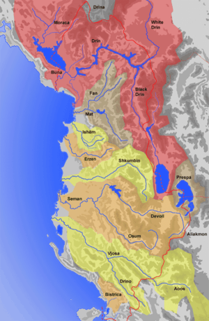
Shkumbin (definite Albanian form: Shkumbini, Latin: Genusus) is a river in central Albania, flowing into the Adriatic Sea. It is considered the dividing line for the two dialects of the Albanian language: Tosk (to the south) and Gheg (to the north).
On various historical periods the river was considered the northernmost natural boundary of the geographic region of Epirus.[1] while during the 5th-6th centuries Shkumbin was the cultural border between the Illyrian and the Greek world.[2]
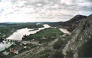
The river is 181 km (112 mi) long. The sources of the Shkumbin river are in the mountains southwest of Lake Ohrid, in the southwestern corner of the Pogradec District. and also in the Librazhd District at Valamra and the Guri i Topit Mountain. The Shkumbin is fed by the waters of the Dushna, Radicina, Bushtrica, Sheja, Hotolisht, and Dragostunja streams. The Shkumbin flows through the town of Librazhd. The Rrapun River joins the Shkumbin at Murrash.
The Shkumbin initially flows north, then northwest, through Qukës, Librazhd, where it turns west and continues through Polis, Elbasan, Cërrik, Peqin and Rrogozhinë. It flows into the Adriatic Sea northwest of Divjakë.
The two canals "Naum Panxhi" and "Ferras" stem out of the river in the Elbasan area and through an irrigation plan system satisfy the agricultural water needs of the Cërrik low plains.[3]
References
- ↑ Mikropoulos A. Tassos.Elevating and Safeguarding Culture Using Tools of the Information Society: Dusty traces of the Muslim culture. Earthlab. ISBN 978-960-233-187-3, p. 320: "Therefore the river referred to as Gennousos in ancient sources... again became a natural border in the north of Epirus"
- ↑ Nicholas Geoffrey Lemprière Hammond. Migrations and invasions in Greece and adjacent areas. Noyes Press, 1976. ISBN 978-0-8155-5047-1. p. 54: "The line of division between Illyricum and the Greek area, 'Epirus Nova', in terms of Roman provincial administration ran somewhere between Scodra and Dyrrachium and then eastwards on the north side of the Shkumbi and Lake Ochrid"
- ↑ From Infoarkiv.com Published on 2003-09-20, last retrieved on 3/21/2010 Kryeministri Fatos Nano mori pjesë sot paradite në inaugurimin e përfundimit të punimeve të Skemës Ujitëse që merr ujë nga Kanalet "Naum Panxhi" dhe "Ferras", në rrethin e Elbasanit.
| ||||||||