Shivpuri district
| Shivpuri district शिवपुरी जिला | |
|---|---|
| District of Madhya Pradesh | |
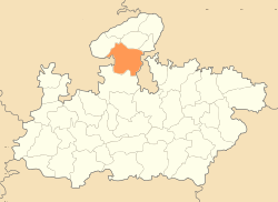 Location of Shivpuri district in Madhya Pradesh | |
| Country | India |
| State | Madhya Pradesh |
| Administrative division | Gwalior |
| Headquarters | Shivpuri |
| Area | |
| • Total | 10,298 km2 (3,976 sq mi) |
| Population (2011) | |
| • Total | 1,725,818 |
| • Density | 170/km2 (430/sq mi) |
| Demographics | |
| • Literacy | 63.73 per cent |
| • Sex ratio | 877 females over 1000 males |
| Major highways | NH3 and NH25 |
| Average annual precipitation | July to September mm |
| Website | Official website |
Shivpuri District is a district of Madhya Pradesh state of India. The town of Shivpuri is the district headquarters. Important towns in the district are: Badarwas, Karera, Khaniyadhana, Kolaras, Narwar and Pichhore.
Shivpuri District has Narwar town of historical importance just east of the Kali Sind River, situated at a distance of 41 km from Shivpuri. It is famous for medieval fortress of Narwar.
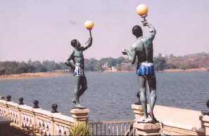
Shivpuri is famous for Madhav National Park. This national park has a varied terrain of forested hills and flat grasslands around the lake. It is very rich in biodiversity. Sakhya Sagar and Madhav Sagar lakes, created on Manier River in 1918, are two important biodiversity support systems in the national park. The Sailing Club situated on Sakhya Sagar at the entrance of the National park is a place of scenic beauty.
Col. G.S. Dhillon is a famous person from Shivpuri District. He was the last survivor of the Historic trial on 5 November 1945 at the Red Fort. He was living at Hatod village in Shivpuri District till his death.
History
Most of present-day Shivpuri District formed Narwar District of the erstwhile princely state of Gwalior, with Shivpuri as administrative headquarters of the district. After India's independence in 1947, the princely states acceded to the Government of India, and Shivpuri District acquired its present boundaries with the addition of the small princely state of Khaniadhana in the southeast of the district, portions of Datia state in the northeast, and most of Pauri estate in the northwest. Shivpuri District became part of the new state of Madhya Bharat, which was merged into Madhya Pradesh in 1956.
Economy
In 2006 the Ministry of Panchayati Raj named Shivpuri one of the country's 250 most backward districts (out of a total of 640).[1] It is one of the 24 districts in Madhya Pradesh currently receiving funds from the Backward Regions Grant Fund Programme (BRGF).[1]
Demographics
According to the 2011 census Shivpuri district has a population of 1,725,818,[2] roughly equal to the nation of The Gambia[3] or the US state of Nebraska.[4] This gives it a ranking of 280th in India (out of a total of 640).[2] The district has a population density of 168 inhabitants per square kilometre (440/sq mi) .[2] Its population growth rate over the decade 2001-2011 was 22.74%.[2] Shivpuri has a sex ratio of 877 females for every 1000 males,[2] and a literacy rate of 63.73%.[2]
References
- ↑ 1.0 1.1 Ministry of Panchayati Raj (September 8, 2009). "A Note on the Backward Regions Grant Fund Programme" (PDF). National Institute of Rural Development. Retrieved September 27, 2011.
- ↑ 2.0 2.1 2.2 2.3 2.4 2.5 "District Census 2011". Census2011.co.in. 2011. Retrieved 2011-09-30.
- ↑ US Directorate of Intelligence. "Country Comparison:Population". Retrieved 2011-10-01.
Gambia, The 1,797,860 July 2011 est.
- ↑ "2010 Resident Population Data". U. S. Census Bureau. Retrieved 2011-09-30.
Nebraska 1,826,341
External links
 |
Sheopur district | Gwalior district | Datia district | |
| Baran district, Rajasthan | |
Jhansi district, Uttar Pradesh | ||
| ||||
| | ||||
| Guna district | Ashoknagar district | Lalitpur district, Uttar Pradesh |
| ||||||||||||||||||||||||||
| ||||||||||||||||||||||||||||||
Coordinates: 25°25′12″N 77°39′36″E / 25.42000°N 77.66000°E