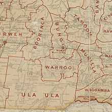
Shire of Warroo
| Shire of Warroo Queensland | |||||||||||||
|---|---|---|---|---|---|---|---|---|---|---|---|---|---|
|
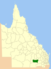
Location within Queensland | |||||||||||||
| Population | 1,064 (2001 census) | ||||||||||||
| • Density | 0.07789/km2 (0.20174/sq mi) | ||||||||||||
| Area | 13,660 km2 (5,274.2 sq mi) | ||||||||||||
| Council seat | Surat | ||||||||||||
| Region | Darling Downs | ||||||||||||
 | |||||||||||||
| Website | Shire of Warroo | ||||||||||||
| |||||||||||||
The Shire of Warroo was a local government area in the Darling Downs region of Queensland, Australia. In March 2008, it became part of the new Maranoa Regional Council.
The administrative centre and only major town in the shire is Surat. The Shire was established on 11 November 1879.
History

Warroo Division was established on 11 November 1879 as one of the original divisions proclaimed under the Divisional Boards Act 1879 with a population of 845.[1]
With the passage of the Local Authorities Act 1902, Warroo Division became the Shire of Warroo on 31 March 1903.
In July 2007, the Local Government Reform Commission released a report recommending a number of amalgamations of local government areas in Queensland. As a result, under the Local Government (Reform Implementation) Act 2007, on 15 March 2008, the new local government area of Roma Region was created, as an amalgamation of five previous local government areas:[2]
- Shire of Bendemere
- Shire of Booringa
- Shire of Bungil
- Town of Roma
- Shire of Warroo
On 26 July 2009, Roma Region was renamed Maranoa Region.[2]
Chairmen
- 1927: Francis Richmond Rouse [3]
References
- ↑ "Proclamation [Warroo Division]". Queensland Government Gazette. 11 November 1879. p. 25:999.
- ↑ 2.0 2.1 "Agency ID11033, Maranoa Regional Council". Queensland State Archives. Retrieved 5 September 2013.
- ↑ Pugh, Theophilus Parsons (1927). Pugh's Almanac for 1927. Retrieved 13 June 2014.
External links
- "Warroo Shire". Queensland Places. Centre for the Government of Queensland, University of Queensland.
- Queensland Department of Local Government - Local Government Directory
| ||||||||||||||||||||||||||
Coordinates: 27°09′15″S 149°04′04″E / 27.15417°S 149.06778°E
