Shire of Murray
This article is about the Western Australian Shire of Murray. For the New South Wales shire, see Murray Shire.
| Shire of Murray Western Australia | |||||||||||||
|---|---|---|---|---|---|---|---|---|---|---|---|---|---|
|
Location in Western Australia | |||||||||||||
| Population | 16,304 (2013 est)[1] | ||||||||||||
| • Density | 9.5312/km2 (24.6856/sq mi) | ||||||||||||
| Established | 1887 | ||||||||||||
| Area | 1,710.6 km2 (660.5 sq mi) | ||||||||||||
| Mayor | N H (Noel) Nancarrow | ||||||||||||
| Council seat | Pinjarra | ||||||||||||
| Region |
Peel region Outer Mandurah | ||||||||||||
| State electorate(s) | Murray-Wellington | ||||||||||||
| Federal Division(s) | Canning | ||||||||||||
|
| |||||||||||||
| Website | Shire of Murray | ||||||||||||
| |||||||||||||
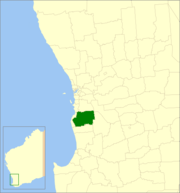
The Shire of Murray is a local government area of Western Australia. It has area of 1,711 square kilometres (661 sq mi) just beyond metropolitan Perth, the capital of Western Australia. It lies about 80 km south of the Perth central business district. The Shire of Murray had a population of 11,969 as at the 2006 census.
History
The Murray Road District was gazetted in December 1887. On 1 July 1961, it became the Shire of Murray.
Wards
The Shire is divided into 6 wards.
- Pinjarra Ward (3 councillors)
- North West Ward (2 councillors)
- North Ward (1 councillor)
- West Ward (4 councillors)
- South Ward (1 councillor)
- East Ward (1 councillor)
Suburbs and towns
Bold denotes major settlements
|
|
|
Population
| Year | Population |
|---|---|
| 1911 | 2,199 |
| 1921 | 3,400 |
| 1933 | 4,060 |
| 1947 | 4,118 |
| 1954 | 3,897 |
| 1961 | 3,592 |
| 1966 | 3,329 |
| 1971 | 4,061 |
| 1976 | 5,035 |
| 1981 | 6,306 |
| 1986 | 6,634 |
| 1991 | 8,157 |
| 1996 | 9,144 |
| 2001 | 10,035 |
| 2006 | 11,969 |
| 2011 | 14,149 |
- At the 1954 census, Mandurah, which had seceded from Murray, had a population of 1,687.
Notes
- ↑ "3218.0 Regional Population Growth, Australia. Table 5. Estimated Resident Population, Local Government Areas, Western Australia". 3 April 2014. Retrieved 11 September 2014.
External links
| ||||||||||||||||||||||||||||||||||||||||||||||||||||||||||||