Shire of Mornington Peninsula
| Shire of Mornington Peninsula Victoria | |||||||||||||
|---|---|---|---|---|---|---|---|---|---|---|---|---|---|
 | |||||||||||||
| Population | 144,685 (2011)[1] | ||||||||||||
| • Density | 200.090/km2 (518.23/sq mi) | ||||||||||||
| Established | 1994 | ||||||||||||
| Area | 723.1 km2 (279.2 sq mi) | ||||||||||||
| Mayor | Cr Lyn bowden | ||||||||||||
| Council seat | Rosebud | ||||||||||||
| Region | Victoria (Australia) | ||||||||||||
| State electorate(s) | Mornington, Nepean, Hastings | ||||||||||||
| Federal Division(s) | Dunkley, Flinders | ||||||||||||
 | |||||||||||||
| Website | Shire of Mornington Peninsula | ||||||||||||
| |||||||||||||
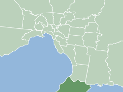
The Shire of Mornington Peninsula is a local government area in Victoria, Australia. It is located to the south of the city of Melbourne on the Mornington Peninsula. It has an area of 723 square kilometres. According to the 2011 Census, it has a population of 144,608 people.[1]
The Shire of Mornington Peninsula came into existence on 15 December 1994 when the Kennett Liberal government amalgamated the previous Shires of Flinders, Hastings and Mornington.
Wards
Each ward has one councillor.
- Mount Eliza
- Mornington
- Balcombe
- Kangerong
- Rosebud
- Truemans
- Rye
- Point Nepean
- Watsons
- Cerberus
- Red Hill
However, this changed at the Victorian Local Government Elections in October 2012 following an electoral representation review by the Victorian Electoral Commission in 2011-2012. The review resulted, at the second attempt after the threat of legal action by the pre-October 2012 Council against the VEC commissioner, in a shire comprising 11 councillors elected from six wards with two three-councillor wards, one two-councillor ward, and three single-councillor wards.[2] The review's findings were adopted by the Minister for Local Government, the Honourable Jeanette Powell, and was declared in the Victorian Government Gazette on 1 March 2012.[3]
Localities, towns and suburbs
- Arthurs Seat
- Balnarring
- Balnarring Beach
- Baxter
- Bittern
- Blairgowrie
- Boneo
- Cape Schanck
- Crib Point
- Dromana
- Fingal
- Flinders
- Hastings
- HMAS Cerberus the area of the naval base is a bounded locality
- McCrae
- Main Ridge
- Merricks
- Merricks Beach
- Merricks North
- Moorooduc
- Mornington
- Mount Eliza
- Mount Martha
- Pearcedale
- Point Nepean
- Point Leo
- Portsea
- Red Hill
- Red Hill South
- Rosebud
- Rosebud West
- Rye
- Safety Beach
- Shoreham
- Somers
- Somerville
- Sorrento
- St Andrews Beach
- Tootgarook
- Tuerong
- Tyabb
See also
- List of Melbourne suburbs for other Melbourne suburbs and municipalities.
References
- ↑ 1.0 1.1 Australian Bureau of Statistics (31 October 2012). "Mornington Peninsula (Local Government Area)". 2011 Census QuickStats. Retrieved 17 October 2012.
- ↑ Victorian Electoral Commission (January 2012), Mornington Peninsula Shire Council - Electoral Representation Review - Final Report.
- ↑ Victorian Government Gazette, 1 March 2012.
External links
- Mornington Peninsula Shire web site
- Metlink local public transport map
- Link to Land Victoria interactive maps
| ||||||||||||||||||||||||||||||||||||