Shire of Moira
| Shire of Moira Victoria | |||||||||||||
|---|---|---|---|---|---|---|---|---|---|---|---|---|---|
|
Location in Victoria | |||||||||||||
| Population | 28,124 (2011 census)[1] | ||||||||||||
| • Density | 6.9528/km2 (18.0076/sq mi) | ||||||||||||
| Established | 1994 | ||||||||||||
| Gazetted | 18 November 1994[2] | ||||||||||||
| Area | 4,045 km2 (1,561.8 sq mi) | ||||||||||||
| Mayor | Cr Peter Mansfield | ||||||||||||
| Council seat | Cobram | ||||||||||||
| Region | Hume | ||||||||||||
| State electorate(s) | |||||||||||||
| Federal Division(s) | Murray | ||||||||||||
|
| |||||||||||||
| Website | Shire of Moira | ||||||||||||
| |||||||||||||
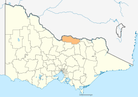
The Shire of Moira is a local government area in the Hume region of Victoria, Australia, located in the north-east part of the state. It covers an area of 4,045 square kilometres (1,562 sq mi) and, at the 2011 Census, had a population of 28,124.[1] It includes the towns of Cobram, Nathalia, Numurkah, Tungamah and Yarrawonga. It was formed in 1994 from the amalgamation of the Shire of Cobram, Shire of Nathalia, Shire of Numurkah, and parts of the Shire of Tungamah and Shire of Yarrawonga.[2]
The Shire is governed and administered by the Moira Shire Council; its seat of local government and administrative centre is located at the council headquarters in Cobram, it also has service centres located in Numurkah and Yarrawonga. The Shire is named after the county of Moira, in which the LGA occupies the northern part of this county.
Council
Current composition
The council is composed of nine councillors elected to represent an unsubdivided municipality.[3]
| Ward | Councillor | Notes | |
|---|---|---|---|
| Unsubdivided | Kevin Bourke | ||
| Wendy Buck | |||
| Gary Cleveland | |||
| Edward Cox | |||
| Brian Keenan | |||
| Peter Mansfield | Mayor (2013–14) | ||
| Marie Martin | |||
| Don McPhee | |||
| Alex Monk | |||
Administration and governance
The council meets in the council chambers at the council headquarters in the Cobram Municipal Offices, which is also the location of the council's administrative activities. It also provides customer services at both its administrative centre in Cobram, and its service centres in Numurkah and Yarrawonga.
See also
List of localities (Victoria)
References
- ↑ 1.0 1.1 Census QuickStats (2011). "Moira (S) – LGA24900". Australian Bureau of Statistics. Government of Australia. Retrieved 10 January 2014.
- ↑ 2.0 2.1 Victoria Government Gazette – Online Archive (1837–1997). "S87 of 1994". State Library of Victoria. State Government of Victoria (published 18 November 1994). p. 4. Retrieved 10 January 2014.
|chapter=ignored (help) - ↑ Local Government in Victoria. "Moira Shire Council". Department of Transport, Planning and Local Infrastructure. State Government of Victoria. Retrieved 10 January 2014.
External links
- Moira Shire Council official website
- Metlink local public transport map
- Link to Land Victoria interactive maps
| ||||||
| ||||||||||||||||||||||||||||||||||||
Coordinates: 36°05′00″S 145°39′00″E / 36.08333°S 145.65000°E