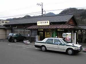
Shiotsu Station
Shiotsu Station 四方津駅 | |
 | |
|---|---|
| Shiotsu Station | |
| Location | |
| Prefecture | Yamanashi (See other stations in Yamanashi) |
| City | Uenohara |
| Neighborhood etc. | 1981 Shiotsu |
| Postal code | 409-0121 |
| (in Japanese) | 山梨県上野原市四方津1981 |
| History | |
| Year opened | 1910 |
| Rail services | |
| Operator(s) | East Japan Railway Company |
| Line(s) | Chūō Rapid Line |
| Statistics | 1,948 passengers/day 2011 |
Shiotsu Station (四方津駅 Shiotsu-eki) is a railway station on the Chūō Main Line of East Japan Railway Company in Uenohara, Yamanashi Prefecture, Japan. The station is 74.0 rail kilometers from Tokyo Station.
Station history
Shiotsu Station first opened on December 15, 1910, as a station for both freight and passenger service on the Japanese Government Railways (JGR) Chūō Main Line. The JGC became the JNR after the end of World War II. Regularly scheduled freight services were discontinued in April 20, 1960. With the dissolution and privatization of the JNR on April 1, 1987, the station came under the control of the East Japan Railway Company. Automated turnstiles using the Suica IC Card system came into operation from November 18, 2001.
Lines
- East Japan Railway Company
- Chūō Rapid Line / Chūō Main Line
Layout
Shiotsu Station has a single island platform and a single side platform serving three tracks, connected to the station building by an overpass.
Platforms
| 1 | ■Chūō Main Line | For Takao, Tachikawa, Shinjuku |
| 2 | ■Chūō Main Line | auxiliary platform |
| 3 | ■Chūō Main Line | For Ōtsuki, Kōfu |
Adjacent stations
| « | Service | » | ||
|---|---|---|---|---|
| Chūō Main Line | ||||
| Uenohara | - | Yanagawa | ||
References
- Miyoshi Kozo. Chuo-sen Machi to eki Hyaku-niju nen. JT Publishing (2009) ISBN 453307698X (Japanese)
- JR全線全駅ステーション倶楽部編(上) [Complete JR Line/Station Compendium (Vol. 1)] (in Japanese). Tokyo, Japan: Bunshun Bunko. September 1988. p. 145. ISBN 4-16-748701-2.
External links
| Wikimedia Commons has media related to Shiotsu Station. |
- Official home page.(Japanese)
Coordinates: 35°36′51″N 139°04′21″E / 35.6142°N 139.0726°E