Shing Mun River
| Shing Mun River | |
|---|---|
|
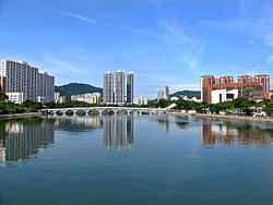
Lek Yuen Bridge and housing estates along the river | |
| Mouth | Tide Cove |
| Length | 7 km |
| Shing Mun River | |||||||||||||
| Chinese | 城門河 | ||||||||||||
|---|---|---|---|---|---|---|---|---|---|---|---|---|---|
| |||||||||||||
Shing Mun River or Shing Mun River Channel (Chinese: 城門河) is a river in Sha Tin, Hong Kong.
History

The original Shing Mun River began at Needle Hill, and flowed into the former Tide Cove (Sha Tin Hoi), a shallow bay. In the 1970s, Tide Cove was drained and turned to Sha Tin New Town. The river was extended through a 7 km long, 200 m wide artificial channel in the middle of the area to flow into Tolo Harbour. Other rivers that had originally flowed into Tide Cove are now tributaries of Shing Mun River or one of its nullahs.
The Shing Mun River channel runs from the Tai Wai area, through the Sha Tin town centre to the Tolo Harbour. It has three main tributaries, namely Tai Wai Nullah, Fo Tan Nullah and Siu Lek Yuen Nullah. Along the Shing Mun River are high-rise residential, commercial and industrial buildings with numerous village type developments scattered around. Several bridges were built to connect the two sides of the Shing Mun River.
Bridges
There are several major bridges across the Shing Mun River:
- Banyan Bridge (翠榕橋) on Fo Tan Road
- Dragon Bridge (錦龍橋) on Sha Tin Road
- Lion Bridge (獅子橋) on Lion Rock Tunnel Road
- Sandmartin Bridge (沙燕橋) on Sha Tin Rural Committee Road
- Lek Yuen Bridge - a pedestrian bridge across the river channel
Pollution problem

The Shing Mun River was once heavily polluted from the indiscriminate discharges from livestock, industrial, commercial and domestic sources.[1] The total organic pollution load from these discharges amount to a population equivalent of 160,000 in the 1980s. At that time, hardly any living creatures were found in the river.
The water quality of Shing Mun River has improved from bad to good in terms of the Water Quality Index since 1993. Lifeforms including fish and invertebrates have also reappeared in the river. In 2001 bioremediation and dredging works began to further improve the river environment. Levels of odour-causing sulphides and E. coli subsequently dropped sharply. But the water quality is still threatened by the polluted condition of Tolo Harbour, which backflows into the Shing Mun River during high tide, causing contamination.[2]
An artificial river bank was also built along a 250-metre section near Man Lai Court, where there are relatively severe sediment accumulations and odour problems.
Current usage
Although the river is primarily designed for the drainage of storm water from Sha Tin with a catchment area of 37 km², it is also a popular place for recreational users such as rowers, anglers, riverside walkers and cyclists.
Many species of trees has been planted along the riverside, such as the Chinese Banyan and a few cotton trees.
Shing Mun River is a popular place for water sports, such as: rowing, canoeing, kayaking and dragon boat racing. There are two boathouses in the river, located at Yuen Wo Road and Shek Mun respectively. The river has a standard of 2000 metres long for regattas.
Gallery
| Wikimedia Commons has media related to Shing Mun River. |
-
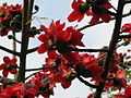
The Cotton tree (Bombax ceiba) flowering on the riverside.
-

Banyan Bridge, with the City One housing estate in the background.
-

View of the Shing Mun River from Tai Wai.
See also
References
- ↑ "Booming Sha Tin to clean up its act" (PDF). South China Morning Post. 26 February 1987. Retrieved 5 October 2014.
High on the agenda is the polluted Shing Mun River, down which dung, carcasses and refuse flow. So bad is the pollution that the large Tolo Harbour reeks with industrial and agricultural rubbish.
- ↑ Ho, Pui Yin (2004). Challenges for an Evolving City. Hong Kong: The Commercial Press (H.K.) Ltd. pp. 240–42. ISBN 962 07 6336 X.