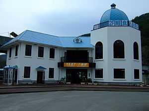
Shimanokoshi Station
Shimanokoshi Station 島越駅 | |
 | |
|---|---|
| Shimanokoshi Station in May 2010 | |
| Location | |
| Prefecture | Iwate (See other stations in Iwate) |
| District | Shimohei |
| Village | Tanohata |
| Neighborhood etc. | Dai-2 Matsumaezawa 1-20 |
| Postal code | 028-8404 |
| (in Japanese) | 岩手県下閉伊郡田野畑村第1地割松前沢1-20 |
| History | |
| Year opened | 1984 |
| Rail services | |
| Operator(s) | Sanriku Railway Company |
| Line(s) | Kita-Rias Line |
| There are no bus services at this station | |
Shimanokoshi Station (島越駅 Shimanokoshi-eki) was a railway station on the Sanriku Railway Company’s Kita-Rias Line located in the village of Tanohata, Iwate Prefecture, Japan. It was 33.4 rail kilometers from the terminus of the line at Miyako Station. The station was destroyed by the 2011 Tōhoku earthquake and tsunami.
Station layout
Shimanokoshi Station had a single side platform serving bidirectional traffic, and a two-story station building.
History
Shimanokoshi Station opened on 1 April 1984, the same day of the privatization of the Japan National Railway (JNR) Kuji Line (which became the Sanriku Railway Company). During the 11 March 2011 Tōhoku earthquake and tsunami, much of the surrounding area was destroyed by a 20 metres (66 ft) tsunami, which also swept away the station building, and parts of the tracks and suspending services on a portion of the Sanriku Railway. The portion of the line from Rikuchū-Noda to Tanohata resumed operations on 1 April 2012.,[1] and services were extended to Omoto on 6 April 2014.[2]。A new station building is expected to be completed by June 2014.[3]。
Adjacent stations
| « | Service | » | ||
|---|---|---|---|---|
| Sanriku Railway Company | ||||
| Omoto | Local | Tanohata | ||
Surrounding area
- Shimanokoshi Post Office
References
- ↑ "三陸鉄道:陸中野田-田野畑で運転再開". Mainichi Shimbun. 2012-04-01. Retrieved 2012-04-01.
- ↑ "三鉄が4月全線再開 南リアス線5日、北リアス線6日". Iwate Nippo. 2014-01-02. Retrieved 2014-01-11.
- ↑ "三陸鉄道、島越駅駅舎再建に遅れ". Yomiuri Newspaper. 2013-09-22. Retrieved 2014-01-11.
External links
- Sanriku Railway station information (Japanese)
| ||||||
Coordinates: 39°54′57.5″N 141°56′22.7″E / 39.915972°N 141.939639°E