Shima, Mie
| Shima 志摩市 | |||
|---|---|---|---|
| City | |||
|
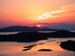
Sunset over Ago Bay, Shima | |||
| |||
 Location of Shima in Mie Prefecture | |||
 Shima
| |||
| Coordinates: 34°20′N 136°50′E / 34.333°N 136.833°ECoordinates: 34°20′N 136°50′E / 34.333°N 136.833°E | |||
| Country | Japan | ||
| Region | Kansai | ||
| Prefecture | Mie Prefecture | ||
| Government | |||
| • -Mayor | Hidekazu Oguchi | ||
| Area | |||
| • Total | 179.67 km2 (69.37 sq mi) | ||
| Population (September 2012) | |||
| • Total | 53,056 | ||
| • Density | 295/km2 (760/sq mi) | ||
| Time zone | Japan Standard Time (UTC+9) | ||
| - Flower | Tea | ||
| Phone number | 0599-44-0001 | ||
| Address | 3098-22 Agocho; Ugata, Shima-shi, Mie-ken 517-0592 | ||
| Website |
www | ||

Shima (志摩市 Shima-shi) is a city located in Mie Prefecture, Japan.
As of September 2012, the city has an estimated population of 53,056 and a population density of 295 persons per km². The total area is 179.67 km².
Geography
Shima is located on the southern half of Shima Peninsula in far eastern Mie Prefecture, facing Ise Bay of the Pacific Ocean. The city has two inlets: Matoya Bay and Ago Bay. Matoya Bay is famous for oyster cultivation and Ago Bay is famous for pearl cultivation. Both of are sightseeing spots and most of the city is within the borders of the Ise-Shima National Park.
Shima has three inhabited islands; Watakano Island, Kashiko Island and Masaki Island. Watakano Island is located in Matoya Bay, and the others are in Ago Bay.
Neighboring municipalities
History
The modern city of Shima was established on October 1, 2004, from the merger of the former town of Shima, absorbing the towns of Ago, Daiō, Hamajima and Isobe (all from Shima District).
Transportation
Railway
- Kintetsu – Kintetsu Shima Line
- Gochi • Kutsukake • Kaminogō • Shima-Isobe • Anagawa • Shima-Yokoyama • Ugata • Shima-Shimmei • Kashikojima
Highway
Local attractions
Noted people
- Yasumasa Hane – Professional go player
External links
| Wikimedia Commons has media related to Shima, Mie. |
- Shima City official website (Japanese)
| ||||||||||||||||||||||||||||||||||||

