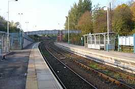
Shildon railway station
| Shildon | |
|---|---|
 | |
| Location | |
| Place | Shildon |
| Local authority | County Durham |
| Grid reference | NZ235257 |
| Operations | |
| Station code | SHD |
| Managed by | Northern Rail |
| Number of platforms | 2 |
|
Live arrivals/departures, station information and onward connections from National Rail Enquiries | |
| Annual rail passenger usage* | |
| 2004/05 | 34,984 |
| 2005/06 |
|
| 2006/07 |
|
| 2007/08 |
|
| 2008/09 |
|
| 2009/10 |
|
| 2010/11 |
|
| 2011/12 |
|
| 2012/13 |
|
| National Rail – UK railway stations | |
| * Annual estimated passenger usage based on sales of tickets in stated financial year(s) which end or originate at Shildon from Office of Rail Regulation statistics. Methodology may vary year on year. | |
| UK Railways portal | |
Shildon railway station is on the Stockton and Darlington Railway in North East England and serves the town of Shildon in County Durham, England built by Timothy Hackworth. The station is on the Tees Valley Line and is operated by Northern Rail, which provides all passenger train services. The station is on the Bishop Line.
Station facilities here have recently been improved as part of the Tees Valley Metro project. The package for this station included new fully lit waiting shelters, renewed station signage and the installation of CCTV. The long-line Public Address system (PA) has been renewed and upgraded with pre-recorded train announcements.
The station is located next to the Shildon Locomotion Museum.
| Preceding station | Following station | |||
|---|---|---|---|---|
| Northern Rail | ||||
| Historical railways | ||||
| Aycliffe Lane Line open, station closed |
Stockton and Darlington Railway | South Church Line open, station closed | ||
| Disused railways | ||||
| Aycliffe Lane Line open, station closed |
North Eastern Railway Stockton and Darlington Railway |
West Auckland Line and station closed | ||
External links
- Train times and station information for Shildon railway station from National Rail
- Bishop Line
Coordinates: 54°37′34″N 1°38′12″W / 54.6262°N 1.6368°W