Shihmen Dam
| Shihmen Dam 石門水庫 | |
|---|---|
 View from the east side of the spillway | |
| Country | Republic of China |
| Location | Fuxing District |
| Coordinates | 24°48′38″N 121°14′39″E / 24.81056°N 121.24417°ECoordinates: 24°48′38″N 121°14′39″E / 24.81056°N 121.24417°E |
| Construction began | 1955 |
| Opening date | 1964 |
| Dam and spillways | |
| Type of dam | Rolled rockfill |
| Impounds | Dahan Creek |
| Height | 133.1 m (437 ft)[1] |
| Length | 360 m (1,180 ft)[1] |
| Spillway type | Gated overflow |
| Spillway capacity | 11,400 m3/s (400,000 cu ft/s)[2] |
| Reservoir | |
| Creates | Shihmen Reservoir |
| Total capacity |
309,120 dam3 (250,610 acre·ft) (nominal) 251,880 dam3 (204,200 acre·ft) (1997)[1] |
| Catchment area | 763.4 km2 (294.8 sq mi)[1] |
| Surface area | 8.0 km2 (2,000 acres)[1] |
| Power station | |
| Turbines | 2x 45 MW[3] |
| Installed capacity | 90 MW[3] |
| Annual generation | 200 million KWh[4] |
Shihmen Dam (Chinese: 石門水壩, also spelled Shimen or Shihman, literally Stone Gate Dam) is a rock fill dam across the Dahan Creek in northern Taoyuan City. The dam's main purposes are water supply, flood control and hydroelectricity generation, and it holds the Shihmen Reservoir (石門水庫), Taiwan's third largest reservoir and artificial lake. Completed in 1964, the dam and reservoir now supply water to more than three million people in northern Taiwan. However, sedimentation issues have impacted and continue to threaten safe dam operations.
Construction history
Plans for a dam on the Dahan Creek were created as early as 1938 when Taiwan was under Japanese rule, but construction was stalled by the intervention of World War II. Preparations at the dam site started in July 1955 as a joint venture between the Republic of China and the United States.[5] After several setbacks caused by flooding, the river was diverted into a tunnel in December 1960.[3] The concrete cofferdam, later to serve as the core of the dam, was finished in 1962; notably, it was the first use of roller-compacted concrete in dam construction.[6] This was immediately followed by placement of rockfill to form the main body of the dam. On May 15, 1963, the diversion tunnel was blocked and the reservoir began to fill. The embankment was topped out in June 1964, at a final cost of NT$ 4.85 billion.[7] Approximately 7,500 people worked in the construction of the dam, with 32 fatalities and over 2,800 injuries.[5] The dam was dedicated on June 14, 1964 by Vice President Chen Cheng, to a crowd of more than four thousand.[5]
Engineers estimated that the natural sedimentation rate would give the reservoir a useful life of at least 71 years without any sediment removal. However, just four months after the reservoir began filling, Typhoon Gloria struck Taiwan, and the resulting floods washed so much sediment into the reservoir that it took 23 years off its expected lifespan.[8] As the reservoir filled, it also inundated several historic landmarks, including the former summer villa of Chiang Kai-shek, the Amuping Stone Bridge and a nearby Earth God shrine.[9][10]
Dam details
Dimensions and storage capacity
Shihmen Dam is a rolled rockfill embankment dam 133.1 metres (437 ft) high and 360 metres (1,180 ft) long, constructed over a 70-metre (230 ft) high concrete core.[1] The main body of the dam contains some 7.06 million cubic metres (9.23 million yd3) of material.[1] A concrete chute spillway is located on the ridge to the east of the dam, and its six tainter gates are capable of a water release of 11,400 cubic metres per second (400,000 cu ft/s).[2] The dam's hydroelectric power station is located at its base, and houses two generators with a combined capacity of 90 megawatts.[3] A small forebay reservoir below Shihmen serves to smooth out irregular water releases from the power plant.
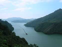
The impounded water behind the dam forms Shihmen Reservoir, one of Taiwan's largest reservoirs with a length of 16 kilometres (9.9 mi) and more than 800 hectares (2,000 acres) of water at full pool. The reservoir had an original design capacity of 309,120 cubic decametres (250,610 acre·ft), with an active or useful capacity of 251,780 cubic decametres (204,120 acre·ft). Sedimentation reduced the full storage capacity to 251,880 cubic decametres (204,200 acre·ft) by 1997 – a nearly 20 percent reduction – and the active capacity was decreased to 233,800 cubic decametres (189,500 acre·ft).[1] As of 2009, the reservoir had an estimated capacity of 210,000 cubic decametres (170,000 acre·ft).[8]
Operations and usage
Water from Shihmen Dam is distributed to 28 districts in Taoyuan City, Hsinchu County and New Taipei, with a combined population of some 3.4 million people and more than 36,500 hectares (90,000 acres) of irrigated land.[7][11] Each year, Shihmen furnishes 181.6 million m3 (147,200 acre feet) of water for irrigation and industrial uses and about 127.4 million m3 (103,300 acre feet) for residential use in downstream areas. In addition, an annual minimum river release of 299.6 million m3 (242,900 acre feet) is maintained to provide a baseflow in the lower Dahan Creek. About 386.3 million m3 (313,200 acre feet) of the aforementioned releases are utilized for hydroelectric generation.[12] The dam's power station generates roughly 200 million kilowatt hours annually and is integral in meeting peaking power demands in northern Taiwan's electricity grid.[7] Hydroelectric power releases peak in late July and August, largely because of air-conditioning usage in Taiwan's northern cities.[12]
Shihmen is one of several key reservoirs in the Tamsui River system used to cut peak flood flows during typhoon events. Dam releases are coordinated with those from Feitsui Dam to the east in order to reduce the severity of flooding.[13] However, sediment accumulation in the reservoir has reduced its effectiveness on large flooding events. As a result, the "frequency with which the Shih-men Dam discharges water down its spillway ranks first among Taiwan's reservoirs. The phrase 'the Shihmen Reservoir is releasing flood water' has become a euphemism for 'your fly is open'."[14] Additionally, large flooding events can cause turbidity levels in the reservoir to increase by over 3,000 times of average, forcing authorities to shut down water supplies.[15] This problem has been exacerbated by the increasing percentage of Shihmen water going to residential and industrial users, who generally demand clearer water than the agricultural users Shihmen was originally intended to supply.[16]
The reduction in storage capacity has also affected Shihmen's ability to provide water during droughts. Demand often exceeds stored water in Shihmen Reservoir during the dry season, forcing frequent water-supply cuts. For weeks in 1994, for example, the drought-stricken Shihmen Dam service area was limited to one day of running water in three.[14]
Among the other benefits of the dam and reservoir is recreation. More than 160,000 people visit Shihmen each year, especially during floodwater releases.[9] It is said that "after its grand opening to the public in 1964, the Shihmen Reservoir has remained one of the top spots on Taiwan's sight-seeing billboards".[17] Recreational and commercial fishing on the reservoir produces about 80,000 kilograms (180,000 lb) of fish each year, generating an annual revenue of NT$29.33 million.[17]
Environmental issues
Poor land use and construction practices in the catchment area of Shihmen Dam have contributed to a severe sedimentation problem in the reservoir. As of 2009, at least 90 million cubic metres (73,000 acre feet) of sediment have accumulated in the reservoir, cutting its storage capacity by 20 percent. This sediment mainly comes from landslides and other erosion-related issues in the steep, rugged drainage basin, which have been exacerbated by deforestation, land-clearing for agriculture, and the opening of roads into mountainous areas.[14] The reservoir, which originally had a maximum depth of over 100 metres (330 ft), is estimated to be no more than 40 metres (130 ft) deep today.[14]
A number of measures have been taken to try and reduce the amount of sediment flowing into Shihmen Reservoir. Because of the construction of hundreds of sediment-trapping dams or sabo dams, the upper reaches of the Dahan and its tributaries are now among the most heavily impounded river systems in Taiwan, with at least 123 such dams along the main stem alone.[14] The largest 24 sabo dams have collectively prevented some 36 million cubic metres (29,200 acre feet) of sediment from reaching Shihmen Reservoir.[18] Only one, the Junghua Dam, is still collecting sediment, although its 16 million cubic metre (13,000 acre foot) capacity is nearly full.[8] These sediment catching dams have also failed on several occasions causing even more debris and silt to wash into Shihmen. Among these was the failure of Baling Dam in 2007, which caused 10 million cubic metres (8,000 acre feet) of sediment to wash downstream, resulting in the destruction of the village of Baling.[19] Dredging efforts on Shihmen Reservoir have also been only partly successful. Beginning in 1985, seven dredging companies removed more than 10 million cubic metres (8,000 acre feet), but the reservoir continued filling with sediment faster than it could be excavated. The capacity of the silt disposal areas was exhausted in 1995.[14] Other measures taken to decrease sediment flow include the construction of retaining walls and the reforestation of clear-cut areas.
The large amount of sediment flowing into the reservoir has also caused unusually high nutrient levels, which leads to frequent eutrophication and algae blooms in the summer. As a result, Shihmen is often considered to be among the worst in water quality among all Taiwan's reservoirs.[14] A large water-quality monitoring system is in place, installed circa 2005 at two points in Shihmen Reservoir. Called "Vertical Profiling System" or "YSI 6600EDS", the system measures a series of water quality factors by depth at intervals of 5 metres (16 ft). The turbidity, chlorophyll content, pH level, and dissolved oxygen levels in the reservoir are sent to the operator of the dam every three hours. A future plan for the system is to record algae growth, allowing action to be taken to prevent hypoxic events in the water.[20] In 2008, the Taiwanese Environmental Protection Agency allocated NT$200 million for eutrophication control projects at Shihmen, Feitsui, Zengwun and Kinmen Reservoirs.[21]
See also
References
- ↑ 1.0 1.1 1.2 1.3 1.4 1.5 1.6 1.7 Reservoirs and Weirs in Taiwan (in Chinese). Taiwan Water Resources Agency, Ministry of Public Affairs. p. 322.
- ↑ 2.0 2.1 "Outline of Shihmen Reservoir". Shihmen Reservoir and its Catchments Management Project. Taiwan Water Resources Agency. Retrieved 2012-07-14.
- ↑ 3.0 3.1 3.2 3.3 "I. Economic Development". Taiwan Review. 1963-07-01. Retrieved 2012-07-14.
- ↑ "Main Facilities: Shihmen Reservoir". Northern Region Water Resources Office. Taiwan Water Resources Agency. 2009. Retrieved 2012-07-14.
- ↑ 5.0 5.1 5.2 Yuan, Lorraine (1964-06-21). "Huge Shihmen Dam Completed After Eight Years Of Hard Work". Taiwan Today. Retrieved 2012-07-14.
- ↑ Penman, A.D.M. "18.4.3: Rollcrete dams". Ethiopian Civil Service University Libraries. Retrieved 2012-07-14.
- ↑ 7.0 7.1 7.2 "Shimen reservoir". library.taiwanschoolnet.org. Retrieved 2012-07-14.
- ↑ 8.0 8.1 8.2 Lin, Rebecca (2010-07-09). "Shihmen Reservoir; A Time Bomb Waiting to Explode". CommonWealth Magazine (450). Retrieved 2014-04-22.
- ↑ 9.0 9.1 "A Cultural Map of Taoyuan". Taoyuan County Government Department of Cultural Affairs. Retrieved 2009-05-09.
- ↑ Kelly, Robert; Bender, Andrew; Brown, Joshua Samuel (2007). Taiwan. Lonely Planet.
- ↑ Pao, William C. "Shimen Dam water shortage shows no sign". The China Post. Retrieved 2009-05-08.
- ↑ 12.0 12.1 Chaves, Paulo; Chang, Fi-John (2008-03-12). "Intelligent reservoir operation system based on evolving artificial neural networks". Advances in Water Resources (2008, number 31): 926–936.
- ↑ "Reservoir Operations". Taipei Feitsui Reservoir Administration. 2012-05-30. Retrieved 2012-07-14.
- ↑ 14.0 14.1 14.2 14.3 14.4 14.5 14.6 Chang, Chin-ju (November 1996). "A Tale of Two Reservoirs – Greater Taipei's Water Woes". Taiwan Panorama. Retrieved 2014-04-22.
- ↑ "CEPD Approves Plan to Renovate Shihmen Reservoir". Taiwan Soil and Water Conservation Bureau. 2006-05-16. Retrieved 2012-07-14.
- ↑ "Searching for Water: Reservoirs continue to play a role, but Taiwan is looking for alternative ways to quench its thirst". Taiwan Review. 2009-02-01. Retrieved 2012-07-14.
- ↑ 17.0 17.1 "Shihmen Tourist Festival". Cultural Tourism Taiwan. Retrieved 2012-07-14.
- ↑ Chen, Su-Chin; Lai, Yi-Cheng; Wang, Chin-Lun (2008). "Typhoons' Effects on Long-Term Watershed Sediment Management in Shihmen Reservoir in Taiwan". Interpraevent. Retrieved 2012-07-14.
- ↑ Tseng, W.H.; Shieh, C.L.; Lee, S.P.; Tsang, Y.C. (April 2009). "A study on the effect of a broken large sabo dam on the sediment transportation in channel – an example of Baling-sabo-dam". EGU General Assembly 2009. The Smithsonian/NASA Astrophysics Data System, Harvard University. Retrieved 2012-07-14.
- ↑ Dumont, Danielle. "Monitoring Reservoir Water Quality in Taiwan Tames Turbidity after Typhoon". WaterWorld. Retrieved 2009-05-08.
- ↑ "EPA to spend NT$200 million on eutrophication control at reservoirs". Taiwan Headlines. 2008-01-09. Retrieved 2009-05-10.