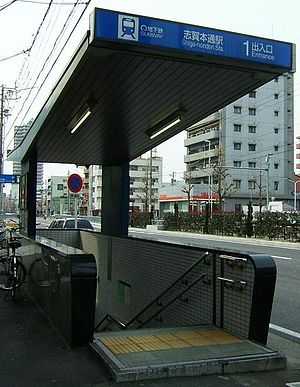
Shiga-hondōri Station
Shiga-hondōri Station 志賀本通駅 | |
 | |
|---|---|
| Location | |
| Prefecture | Aichi (See other stations in Aichi) |
| City | Nagoya |
| Ward | Kita |
| Neighborhood etc. | Shiga-hondōri 2-47 |
| Postal code | 462-0853 |
| (in Japanese) | 名古屋市北区志賀本通二丁目47 |
| History | |
| Year opened | 1971 |
| Rail services | |
| Station number(s) | M10 |
| Operator(s) | Transportation Bureau City of Nagoya |
| Line(s) | Meijō Line |
| Statistics | 6,100 passengers/day 2007 |
Shiga-hondōri Station (志賀本通駅 Shiga-hondōri-eki) is a railway station in Kita-ku, Nagoya, Aichi Prefecture, Japan[1]
It was opened on 20 December 1971.
Lines
- Nagoya Municipal Subway
- Meijō Line (Station number: M10)
Layout
Platforms
| 1 | ■Meijō Line | For Sakae, Kanayama, Aratama-bashi, and Nagoyakō |
| 2 | ■Meijō Line | For Ōzone and Motoyama |
Platform Map
The following is a map of the platform and the car placement.
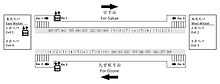
Platform of Shigahondori Station
Internal Station Map
(map to come)[1]
Blue denotes upward moving escalators.
Pink denotes downward moving escalators.
External Exit Placement
(map to come)
Disabled or Injured Route Information
From either platform, there are elevators to the east wicket (exit 1 & 4). From the east wicket, there is an elevator to ground level off exit 1.
Both escalators from the platform for Ozone are upward moving. Both escalators from the platform for Sakae are upward moving.
All exits are stairwells.
Adjacent stations
| « | Service | » | ||
|---|---|---|---|---|
| Nagoya Municipal Subway | ||||
| Meijō Line | ||||
| Kurokawa | - | Heian-dōri | ||
See also
-
 Media related to Shiga-hondōri Station at Wikimedia Commons
References
- ↑ 1.0 1.1 志賀本通 [Shiga-hondōri] (in Japanese). Transportation Bureau City of Nagoya. Retrieved 19 November 2010.
Coordinates: 35°11′47″N 136°55′16″E / 35.1963°N 136.9212°E