Shibukawa, Gunma
| Shibukawa 渋川市 | ||
|---|---|---|
| City | ||
| ||
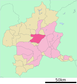 Location of Shibukawa in Gunma Prefecture | ||
 Shibukawa Location in Japan | ||
| Coordinates: 36°23′22″N 139°03′48″E / 36.38944°N 139.06333°ECoordinates: 36°23′22″N 139°03′48″E / 36.38944°N 139.06333°E | ||
| Country | Japan | |
| Region | Kantō | |
| Prefecture | Gunma Prefecture | |
| Government | ||
| • Mayor | Sadaji Akutsu (since September 2009) | |
| Area | ||
| • Total | 240.42 km2 (92.83 sq mi) | |
| Population (May 31, 2011) | ||
| • Total | 84,160 | |
| • Density | 350.05/km2 (906.6/sq mi) | |
| Time zone | Japan Standard Time (UTC+9) | |
| Address |
80 Ishihara, Shibukawa-shi, Gunma-ken 377-8501 | |
| Phone number | 0279-22-2111 | |
| Website | http://www.city.shibukawa.gunma.jp/index.html | |


Shibukawa (渋川市 Shibukawa-shi) is a city located in the extreme northwest of the Kantō Plain, in the center of landlocked Gunma Prefecture, Japan. Encompassing the juncture of the Tone River and Agatsuma River, it is about 120 kilometres (75 miles) from Tokyo. Due to its location at the geographical center of the nation, Shibukawa is known as the Bellybutton of Japan (日本のおへそ, nihon no oheso). The city was founded on April 1, 1954.
Shibukawa originally grew to prosperity as an inn town, but even today is in a central location between Numata and Maebashi. Also, anyone going to a number of famous hot spring resorts, such as Kusatsu, Shima, or Ikaho must pass through Shibukawa.
As of May 31, 2011, the city has an estimated population of 84,160, with 31,289 households and a density of 350.05 persons per km². The total land area is 240.42 km2 (92.83 sq mi).
Geography
Shibukawa is located at a central point (36°29′ N, 139°00′ E) of the Japanese Archipelago and is thus known as the Bellybutton of Japan (日本のおへそ, nihon no oheso). The city encompasses an area of 240.42 square kilometres (92.83 sq mi).
To the west is Mount Haruna, and to the east is Mount Akagi. To the north are Mount Onoko and Mount Komochi. The Tone River flows from the north (between Mount Akagi and Mt. Komochi) southward through the city, while the Agatsuma River flows from the west (between Mt. Onoko and Mount Haruna), merging with the Tone River near the center of the city.
Shibukawa's highest altitude is 1,565 m (5,135 ft) above sea level; its lowest point is 2,701 m (8,862 ft) above sea level. The majority of the city lies between 200 to 800 metres (656 to 2,625 feet) above sea level
Farmland covers 49.88 km2 (19.26 sq mi) (20.8% of the city), housing covers 20.31 km2 (7.84 sq mi) (8.4%), and mountains and forests cover 77.39 km2 (29.88 sq mi) (32.2%). The remaining 92.84 km2 (35.85 sq mi) (38.6%) has other land uses.
Adjacent municipalities
- To the north: Numata, Showa, Takayama
- To the east: Maebashi
- To the south: Maebashi, Shinto, Yoshioka
- To the west: Takasaki, Higashiagatsuma, Nakanojō
History
- Shibukawa developed as an inn town on the old Mikuni Road.
- In 1889 - the village of Shibukawa gained town status to become the town of Shibukawa.
- On April 1, 1954 - Shibukawa absorbed the villages of Furumaki, Kanashima and Toyoaki to become the city of Shibukawa.
- On February 20, 2006 - Shibukawa absorbed the town of Ikaho, the villages of Komochi and Onogami (all from Kitagunma District), and the villages of Akagi and Kitatachibana (both from Seta District).
Demographics
Shibukawa's population, as of April 2008, was 86,395. There were 42,313 males and 44,082 females. The number of households was 30,870. The population density was 359 persons per km².
Twin towns – Sister cities
Foligno in Umbria, Italy is Shibukawa's sister city. Logan City, Queensland, Australia is designated as a Friendship City with Shibukawa.
Festivals
Shibukawa calls itself "The Bellybutton of Japan" (日本のおへそ) and hosts the Bellybutton Festival (へそ祭り) every year in late July. The festival is based on a traditional Japanese form of entertainment where revelers paint a face on their torsos and stomachs and pretend it is a head.A kimono is then wrapped around the waist and the person's real head is hidden by a large cloth hat. The belly button is traditionally painted into a mouth.These days, modern motifs and Japanese anime designs have crept into the festival, which city officials said is all about having fun.[1][2]
Transportation
Rail
- East Japan Railway Company
- Ikaho Ropeway (Hototogisu Station and Miharashi Station)
Roads
- Expressway
- Kan-Etsu Expressway (Shibukawa-Ikaho Interchange, Akagi Interchange)
- National Highways
- National Route 17
- National Route 353
Schools
Shibukawa has four high schools:
- Shibukawa High School
- Shibukawa Girls' High School
- Shibukawa Kougyou High School
- Shibukawa Seisui High School
There are ten junior high schools:
- Akagi North Junior High School
- Akagi South Junior High School
- Furumaki Junior High School
- Hokkitsu Junior High School
- Ikaho Junior High School
- Kanashima Junior High School
- Komochi Junior High School
- Shibukawa Junior High School
- Shibukawa North Junior High School
- Onogami Junior High School.
Finally, there are seventeen elementary schools:
- Ikaho Elementary School
- Furumaki Elementary School
- Kamishiroi Elementary School
- Kanashima Elementary School
- Miharada Elementary School
- Nagaou Elementary School
- Nagumo Elementary School
- Nakagou Elementary School
- Onogami Elementary School
- Shibukawa North Elementary School
- Shibukawa South Elementary School
- Shibukawa West Elementary School
- Tachibana North Elementary School
- Tachibana South Elementary School
- Tousen Elementary School
- Toyoaki Elementary School
- Tsukuda Elementary School
Attractions
- Shibukawa Skyland Park - an amusement park
- Ikaho Green Bokujou - a farm designed to show its customers various things about farming
- Ikaho Sistina Museum- an op art museum which also has a Sistine Chapel replica
- Japan Chanson Museum - a museum dedicated to the chanson style of music
- Shibukawa Sōgō Park- a large park encompassing hiking trails, campsites, tennis courts, a baseball diamond, a running track, and various other recreational facilities
- Onoike Ajisai Park- a hydrangea park with a pond and hiking trails
- Shibukawa Sky Terume - a hot spring in a building which looks something like a spaceship
Trivia
Shibukawa is the home town of Takumi Fujiwara, the main character in Initial D. Many scenes of the live action movie were taped on location in Shibukawa.
References
- "市内小・中学校リンク集". Shibukawa City Official Site. July 2006. Archived from the original on 2006-08-27. Retrieved 2006-08-29. (Japanese)
- "合併の変遷". Shibukawa City Official Site. June 2006. Archived from the original on 2006-06-15. Retrieved 2006-06-16. (Japanese)
- "渋川市の統計". Shibukawa City Official Site. June 2006. Archived from the original on 2006-10-06. Retrieved 2006-06-16. (Japanese)
- "渋川市の地勢と気候". Shibukawa City Official Site. June 2006. Archived from the original on 2008-04-10. Retrieved 2008-05-28. (Japanese)
- "MapionBB". MapionBB. August 2006. Retrieved 2006-08-29. (Japanese)
- "渋川市住民基本台帳人口/渋川市". Shibukawa City Official Site. April 2008. Archived from the original on 2008-05-01. Retrieved 2008-05-28. (Japanese)
External links
| Wikimedia Commons has media related to Shibukawa, Gunma. |
- Shibukawa City official website (Japanese)
| |||||||||||||||||