Sheridan Township, Cowley County, Kansas
| Sheridan Township | |
|---|---|
| Township | |
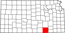
 Location in Cowley County | |
| Coordinates: 37°16′14″N 096°46′52″W / 37.27056°N 96.78111°WCoordinates: 37°16′14″N 096°46′52″W / 37.27056°N 96.78111°W | |
| Country | United States |
| State | Kansas |
| County | Cowley |
| Area | |
| • Total | 35.76 sq mi (92.62 km2) |
| • Land | 35.76 sq mi (92.61 km2) |
| • Water | 0 sq mi (0.01 km2) 0.01% |
| Elevation | 1,266 ft (386 m) |
| Population (2000) | |
| • Total | 159 |
| • Density | 4.4/sq mi (1.7/km2) |
| GNIS feature ID | 0469580 |
Sheridan Township is a township in Cowley County, Kansas, USA. As of the 2000 census, its population was 159.
Geography
Sheridan Township covers an area of 35.76 square miles (92.6 km2) and contains no incorporated settlements. According to the USGS, it contains one cemetery, Silver Creek.
The streams of Plum Creek and Plum Creek run through this township.
References
External links
| |||||||||||||||||||||||||