Shek Kip Mei
| Shek Kip Mei | |||||||||||||||
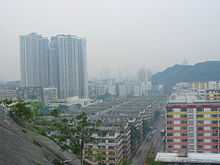 Shek Kip Mei Estate (foreground) in 2006. The area on the left has since been redeveloped. | |||||||||||||||
| Chinese | 石硤尾 | ||||||||||||||
|---|---|---|---|---|---|---|---|---|---|---|---|---|---|---|---|
| |||||||||||||||
Shek Kip Mei, originally known as Shek Kap Mei, is an area in New Kowloon, to the northeast of the Kowloon Peninsula of Hong Kong. It borders Sham Shui Po and Kowloon Tong.
History
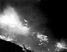
A major fire on 25 December 1953, destroyed the Shek Kip Mei shantytown of immigrants from Mainland China that had fled to Hong Kong, leaving 53,000 people homeless.
After the fire, the governor Alexander Grantham launched a public housing programme to introduce the idea of "multi storey building" for the immigrant population living there. The standardised new structures offered fire- and flood-resistant construction to previously vulnerable hut dwellers. The programme involved demolishing the rest of the makeshift houses left untouched by the fire, and the construction of the Shek Kip Mei Low-cost Housing Estate in their stead. The apartments were small, only about 300 square feet (28 m2). Each unit could house five people, and each building had a capacity of 2,500 residents.[1] The rent was HK$17 per square foot per month, while the rent for a commercial store downstairs was HK$100 per month. Foreign tourists visiting the apartment complexes referred to them as "prisons". Indeed, some scholars have argued that the government has been overstating the role of the fire in the history of public housing in Hong Kong.[2]
At the north of Shek Kip Mei is Tai Wo Ping (大窩坪), along Beacon Hill. This was a cottage area (a type of resettlement accommodation) from the 1950s to 1970s, but it has been developed into a public housing estate, Chak On Estate (澤安邨), and two private housing estates, Beacon Heights (畢架山花園) and Dynasty Heights (帝景峰).[3][4]
Present
The Government has backed off from its plans to redevelop the area, following great opposition from many who believe they symbolized the history of Hong Kong. An alternative plan to renovate it for use as a hostel has also been proposed.
Shek Kip Mei now has several types of housing including the public apartments, Pak Tin Estate and private housing such as Beacon Heights and Dynasty Heights. Several malls and churches can also be found in the area now.
Transportation
Since 1979 it has been served by Shek Kip Mei Station on the MTR at Woh Chai Street and Wah Chi Street.
Route 7 (Hong Kong) passes to the north of the area and accessed via Nam Cheong Street.
KMB and New World First Bus operates a number or routes that travel within the area.
See also
References
- ↑ Wiltshire, Trea. [First published 1987] (republished & reduced 2003). Old Hong Kong – Volume Three. Central, Hong Kong: Text Form Asia books Ltd. Page 7. ISBN Volume Three 962-7283-61-4
- ↑ Smart, Alan. (2006). The Shek Kip Mei Myth: Squatters, Fires And Colonial Rulers in Hong Kong, 1950–1963.
- ↑ Tai Wo Ping Cottage Area
- ↑ Hong Kong in the Post War Years
External links
| Wikimedia Commons has media related to Shek Kip Mei. |
- Pictures of the 1953 fire and early resettlement buildings
- Jockey Club Creative Arts Centre project website
- Video showing Shek Kip Mei just after the fire
Coordinates: 22°20′03″N 114°10′08″E / 22.33426°N 114.16881°E