Shariki, Aomori
| Shariki 車力村 | |
|---|---|
| Former municipality | |
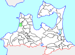 Location of Shariki in Aomori Prefecture | |
 Shariki Location in Japan | |
| Coordinates: 40°56′50.9″N 140°21′33.4″E / 40.947472°N 140.359278°ECoordinates: 40°56′50.9″N 140°21′33.4″E / 40.947472°N 140.359278°E | |
| Country | Japan |
| Region | Tōhoku |
| Prefecture | Aomori Prefecture |
| District | Nishitsugaru |
| Merged |
February 11, 2005 (now part of Tsugaru) |
| Area | |
| • Total | 62.17 km2 (24.00 sq mi) |
| Population (February 1, 2005) | |
| • Total | 5,730 |
| • Density | 92.16/km2 (238.7/sq mi) |
| Time zone | Japan Standard Time (UTC+9) |
| Symbols | |
| - Tree | Japanese black pine |
| - Flower | Lilium |
| - Bird | Japanese Bush-warbler |
Shariki (車力村 Shariki-mura) was a village located in Nishitsugaru District in western Aomori Prefecture, Japan.
Shariki was located on the west coast of Tsugaru Peninsula facing the Sea of Japan. The area was part of Hirosaki Domain during the Edo period. After the Meiji Restoration, Shariki Village was created in 1889.
On February 11, 2005, Shariki, along with the town of Kizukuri, and the villages of Inagaki, Kashiwa and Morita (all from Nishitsugaru District), was merged to create the city of Tsugaru, and thus no longer exists as an independent municipality.
At the time of its merger, Shariki had an estimated population of 5,730 and a population density of 92.16 persons per km². The total area was 62.17 km². The village economy was dominated by agriculture and commercial fishing.