Shōwa, Fukushima
| Shōwa 昭和村 | |||
|---|---|---|---|
| Village | |||
|
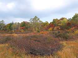
Komado wetlands in Shōwa, Fukushima | |||
| |||
 Location of Shōwa in Fukushima Prefecture | |||
 Shōwa
| |||
| Coordinates: 37°20′9″N 139°36′38″E / 37.33583°N 139.61056°ECoordinates: 37°20′9″N 139°36′38″E / 37.33583°N 139.61056°E | |||
| Country | Japan | ||
| Region | Tōhoku | ||
| Prefecture | Fukushima Prefecture | ||
| District | Ōnuma District | ||
| Area | |||
| • Total | 209.34 km2 (80.83 sq mi) | ||
| Population (September 2014) | |||
| • Total | 1,332 | ||
| • Density | 6.36/km2 (16.5/sq mi) | ||
| Time zone | Japan Standard Time (UTC+9) | ||
| Phone number | 0241-57-2114 | ||
| Address | 350 Shimo-Nakatsugawa Sumiyoshi 415, Shōwa-mura, Ōnuma-gun, Fukushima-ken 968-0103 | ||
| Website | Official HP | ||
Shōwa (昭和村 Shōwa-mura) is a village located in Ōnuma District, Fukushima Prefecture, in northern Honshū, Japan. As of September 2014, the village had an estimated population of 1,332 and a population density of 6.36 persons per km². The total area was 209.34 km².
Geography
Shōwa is located in the western portion of the Aizu region of Fukushima Prefecture. The climate is like many other parts of northern Japan, with cold winters and snowfall averaging 2 meters.
- Mountains : Mount Hakase
- Rivers : Nojiri River
Neighboring municipalities
History
The area of present-day Shōwa was part of ancient Mutsu Province and formed part of the holdings of Aizu Domain during the Edo period. After the Meiji Restoration, it was organized as part of Ōnuma District.
Modern Shōwa village was founded on November 23, 1927 through a merger of the villages of Nojiri and Oashi. It was raised to town status on April 1, 1961.
Education
- Shōwa Village Shōwa Middle School
- Shōwa Village Shōwa Elementary School
Transportation
Highway
Local attractions
- Komado wetlands
External links
![]() Media related to Shōwa, Fukushima at Wikimedia Commons
Media related to Shōwa, Fukushima at Wikimedia Commons
- Official website (Japanese)
| |||||||||||||||||||||
