Severnaya Zemlya
| Russian: Се́верная Земля́ | |
|---|---|
|
Severnaya Zemlya, Russia | |
|
Location of Severnaya Zemlya. | |
| Geography | |
| Location | Arctic Ocean |
| Coordinates | 79°30′N 97°45′E / 79.500°N 97.750°E |
| Archipelago | Severnaya Zemlya |
| Area | 37,000 km2 (14,000 sq mi) |
| Country | |
| Demographics | |
| Population | 0 |
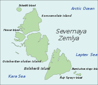
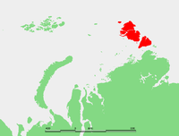
Coordinates: 79°30′N 97°45′E / 79.500°N 97.750°E Severnaya Zemlya (Russian: Се́верная Земля́, Northern Land) is an archipelago in the Russian high Arctic. It is located off mainland Siberia's Taymyr Peninsula across the Vilkitsky Strait. This archipelago separates two marginal seas of the Arctic Ocean, the Kara Sea in the west and the Laptev Sea in the east.
Severnaya Zemlya was first noted in 1913 and first charted in 1930–32, making it the last archipelago on Earth to be discovered.[1] Politically, they are part of Russia's Krasnoyarsk Krai region, but are uninhabited by humans except for an Arctic base.
Severnaya Zemlya is notable in connection with the ongoing multi-year Arctic sea ice decline. Until recently, the islands were a portion of Eurasia which remained firmly within the grip of the ice even at its smallest extent during the late summer melt season, blocking the Northeast Passage between the Atlantic and Pacific. By the late summer of 2012, however, the permanent ice had reached a record low extent and open water appeared to the north of the archipelago.[2]
History

Although located not far off the northern coast of Russia, Severnaya Zemlya was not formally recorded until the 20th century. Earlier explorers did report a land mass in the general areas, most notably a report by Matvei Gedenschtrom and Yakov Sannikov in 1810 from their explorations out of New Siberian Islands.
Nested among the ice-locked waters of the Arctic Ocean, Severnaya Zemlya was not put on the map until the 1913–1915 Arctic Ocean Hydrographic Expedition of icebreakers Taimyr and Vaigach. The chief designer and the first captain of Vaygach was Russian Imperial Naval officer Aleksandr Vasiliyevich Kolchak. The expedition, organized by Kolchak and launched in 1910, was led by Boris Vilkitsky. This venture accomplished its goal of exploring the uncharted areas of the Northern Sea Route in what was seen as the culmination of an enterprise initially conceived by emperor Peter I the Great to map the Northern Sea Route to the East.
On 3 September 1913 (22 August 1913 in the Julian calendar used by Russia at the time), the expedition raised the Russian flag on what they believed to be a single island. This new land was named Emperor Nicholas II Land, (Russian: Zemlya Imperatora Nikolaya II), after Emperor Nicholas II of Russia.[3] However, in 1926 the Presidium of the Central Executive Committee of the USSR renamed this land Severnaya Zemlya.[4]
On 15 May 1928 the islands were overflown by Umberto Nobile and his crew in the Airship Italia. In the spring of 1931 the expedition of Georgy Ushakov and Nikolay Urvantsev (1930–1932) showed Severnaya Zemlya to be divided by four main islands, making the first detailed map of the archipelago during this expedition.[1] The Graf Zeppelin, during its polar flight of July 1931, determined there were at least two islands (a full month after Ushakov and Urvantsev).
The islands of Severnaya Zemlya continued to be studied by a team of geologists from NIIGA (the Scientific Research Institute of Arctic Geology) in St. Petersburg under B. Kh. Egiazarov from 1948 to 1954, who compiled a comprehensive geological map.[5]
There has been a request at the Krasnoyarsk Krai Legislative Assembly to reinstate the former name of Severnaya Zemlya as "Emperor Nicholas II Land". This request has been rejected for the time being.[4]
Main islands
Severnaya Zemlya comprises four major islands – October Revolution, Bolshevik, Komsomolets, and Pioneer – and around 70 smaller islands, covering a total area of about 37,000 km2 (14,300 sq mi).[5]
October Revolution
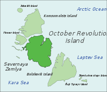
October Revolution Island (Russian: Остров Октябрьской Революции, Ostrov Oktyabrskoy Revolyutsii) is the largest island of the Severnaya Zemlya group in the Russian Arctic.
The area of this island has been estimated at 14,170 km2 (5,470 sq mi) making it the 56th largest island in the world.[6] It rises to a height of 965 m (3,166 ft) on Mount Karpinsky. Half the island is covered with glaciers reaching down into the sea. In the sections free from ice, the vegetation is desert or tundra. The island was first explored and named by the expedition of G.A. Ushakov and Nikolay N. Urvantsev in 1930 – 32.[7]
October Revolution Island houses five domed ice caps; clockwise from north, they are named: Rusanov, Karpinsky, University, Vavilov and Albanov.[8] The Vavilov Meteorological Station was operated from 1974 to 1988 on the northern part of the Vavilov Ice Cap.[9] Other minor ice caps on the island include the Mal'yutka Glacier. The Podemnaya River and the Bolshaya River drain to the northwest between the Vavilov and Albanov glaciers, and the Bedovaya and Obryvistaya Rivers drain to the north between Albanov and Rusanov.[10]
Ostrov Vysokiy is an islet located in a small bay on October Revolution Island's southwest shores.
Bolshevik
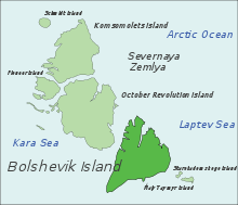
Bolshevik Island (Russian: о́стров Большеви́к, pronounced [ˈostrəv bəlʲʂɨˈvʲik]) is the southernmost and second largest island in the group, located across the Shokalsky Strait from October Revolution Island. The area of this island has been estimated at
11,312 km2 (4,370 sq mi).
Bolshevik Island is mountainous, reaching a height of 935 m (3,068 ft). and it houses an Arctic base named Prima. About 30% of the island is covered by glaciers, while the coastal plains have a sparse vegetation of moss and lichen. Its northwestern shore has some fjords; the most important are: Fiord Tel'mana, Fiord Spartak and Fiord Partizan.
Bolshevik Island houses at least three glacier systems: Leningrad and Semenov-Tyan Shansky glaciers, as well as a smaller glacier, Kropotkin.[11]
Ostrov Tash is a small island located on Bolshevik's southern shore. Lavrov Island is located off the NE shore and Ostrov Lishniy off its northern tip.
Komsomolets
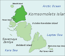
Komsomolets Island (Russian: остров Комсомолец) is the northernmost island of the Severnaya Zemlya group in the Russian Arctic, and the third largest island in the group. It is the 82nd largest island on earth.
The northernmost point of the island is called the Arctic Cape. This is the launching point for many Arctic expeditions.
The area of this island has been estimated at 9,006 km2 (3,477 sq mi). It rises to a height of 780 m (2,559 ft). Some 65% of the island is covered with glaciers. The soil is mostly composed of loose loam and sand. Komsomolets Island is home to the largest ice cap in Russia, the Academy of Sciences Ice Cap.[12] Komsomolets island is largely covered by the Academy of Sciences Ice Cap – an 819 m (2,687 ft) thick ice dome reaching 749 m (2,457 ft) above sea level and covering 5,575 km2 (2,153 sq mi) of the island.[11]
The soil of the island is mostly composed of loose loam and sand, a tundra desert scattered with mosses and lichens.[13] The island was first explored and named by the expedition of Georgy Ushakov and Nikolay Urvantsev in 1930 – 32. In keeping with their scheme of naming the islands after events and movements of the Russian Revolution, this island was named in honour of the members of the Komsomol, the "Communist Union of Youth".
Off the NW shores of Komsomolets Island lies a group of islets known as Ostrova Dem'yana Bednogo .
Pioneer Island
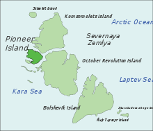
Pioneer Island, Ostrov Pioner in Russian. It is the westernmost of the large islands of the Severnaya Zemlya group. Pioneer island measures 1,527 km2 (590 sq mi) in area.
This island houses the Pioneer Glacier.[11]
Off Pioneer Island's southwestern end lies Krupskoy Island. This is a fairly large island, over 20 km (12 mi) in length and about 11 km (6.8 mi) in width. The sound that separates it from Pioneer is only 0.5 km (0.31 mi) in width.
Geological and biological data:[14][15]
This island should not be confused with Pioneer Island in Canada (Latitude: 76° 57' 0 N, Longitude: 96° 49' 60 W).
Schmidt Island
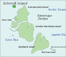
Schmidt Island, measuring 467 km2 (180 sq mi), is located at the far northwestern end of the archipelago. This island is quite detached from the whole Severnaya Zemlya group. It is also its northernmost island and is fully in the region of permanent sea ice.
This island is almost entirely covered by the Schmidt Ice Cap. Owing to its exposed position, the climate in the Schmidt Island's area is much colder than in the rest of the archipelago.[16] The island was named after the Soviet scientist Otto Schmidt.
Minor islands and island groups
- The Sedov Archipelago is located just west of October Revolution Island on the Kara Sea side. The main islands of this archipelago are Sredny (the longest island), Domashnyy, Strela, and Figurnyy. Close to the shore of October Revolution Island lies Obmannyy Island and 32 km (20 mi) further offshore southwards lies Dlinnyy Island. These are sometimes included as part of the Sedov Group. Golomyanniy Meteorological Station, located on the western tip of Sredniy Island at 79°33′N 90°38′E / 79.550°N 90.633°E, has been taking continuous measurements since 1954.[17] An official request has been forwarded to rename Domashnyy Island as Svyatoy Anastasii (остров Святой Анастасии), St. Anastasia Island.[18]
- The Krasnoflotskiye Islands are located just south of October Revolution Island in the Kara Sea. They extend from north to south in an almost straight line 78°36′N 98°40′E / 78.600°N 98.667°E. The main islands are Sverdlova (very close to Mys Sverdlova on the coast), Bolshoy, Sredniy and Greben far offshore. 35 km (22 mi) to the SW of Greben Island lie two small islets called Opasnye, which are also part of this group. There is an Arctic Station in the Krasnoflotskiye Islands (AS-042).[19]
- Maly Taymyr Island (232 km2 or 90 sq mi) is located in the Laptev Sea, off the far southeastern end of Bolshevik Island 78°07′N 107°15′E / 78.117°N 107.250°E. There has been an official request to rename this island Alexei Island, after the son of Czar Nicholas II of Russia. Starokadomsky Island is close by to Maly Taymyr, located off its northwestern side and separated from it by a narrow 6 km wide sound.
- Lishniy Island is 8 km (5 mi) long and 4.2 km (2.6 mi) wide. It lies in a bay off Bolshevik Island's northern end 79°11′N 103°24′E / 79.183°N 103.400°E. South of it lies Yuzhnyy, a smaller island, and two islets. Lishniy off Severnaya Zemlya should not be confused with Lishniy Island south of the Firnley Islands.
Climate
Severnaya Zemlya is consistently cold and quite dry, with a mean annual temperature of −14.8 °C (5.4 °F), mean annual precipitation of about 420 mm (16.5 in), and generally overcast skies. Monthly average temperature ranges from −28 °C (−18.4 °F) in February to 1 °C (33.8 °F) in July. The archipelago sees large temperature fluctuations during winter months, as low-pressure cyclonic activity originating in the North Atlantic make their way across the Arctic, bringing precipitation and higher temperatures. These cyclones are most common in September and October, which see 30% of annual precipitation. Snowfall in summer is common as temperatures hover around 0 °C (32 °F), although higher temperatures occur when warm air masses move north from Siberia.[17] The climate data below, taken from the Golomyanniy Meteorological Station gives an indication of the weather experienced in the archipelago.
| Climate data for Golomyanniy Meteorological Station | |||||||||||||
|---|---|---|---|---|---|---|---|---|---|---|---|---|---|
| Month | Jan | Feb | Mar | Apr | May | Jun | Jul | Aug | Sep | Oct | Nov | Dec | Year |
| Record high °C (°F) | 0 (32) |
−1 (30) |
−1 (30) |
1 (33) |
4 (39) |
14 (57) |
10 (50) |
9 (48) |
3 (37) |
0 (32) |
0 (32) |
0 (32) |
14 (57) |
| Average high °C (°F) | −25 (−13) |
−26 (−14) |
−24 (−11) |
−18 (0) |
−8 (17) |
−1 (31) |
2 (35) |
1 (34) |
−3 (26) |
−12 (10) |
−19 (−2) |
−23 (−9) |
−13 (8.7) |
| Daily mean °C (°F) | −27 (−16) |
−28 (−18) |
−27 (−16) |
−20 (−4) |
−10 (14) |
−2 (28) |
1 (33) |
0 (32) |
−4 (24) |
−14 (6) |
−22 (−7) |
−25 (−13) |
−14.8 (5.3) |
| Average low °C (°F) | −31 (−23) |
−31 (−23) |
−30 (−22) |
−23 (−9) |
−12 (10) |
−3 (26) |
0 (32) |
−1 (30) |
−6 (21) |
−17 (1) |
−25 (−13) |
−28 (−18) |
−17.2 (1) |
| Record low °C (°F) | −46 (−50) |
−44 (−47) |
−46 (−50) |
−41 (−41) |
−24 (−11) |
−13 (8) |
−4 (24) |
−11 (12) |
−21 (−5) |
−35 (−31) |
−43 (−45) |
−44 (−47) |
−46 (−50) |
| Avg. precipitation days | 15 | 14 | 15 | 13 | 20 | 19 | 17 | 19 | 21 | 20 | 14 | 15 | 202 |
| Avg. rainy days | 0 | 0 | 0 | 0 | 1 | 0 | 0 | 10 | 9 | 4 | 0 | 0 | 22 |
| Avg. snowy days | 15 | 14 | 15 | 13 | 19 | 17 | 9 | 12 | 17 | 20 | 14 | 15 | 180 |
| Source: Weather Reports[20] | |||||||||||||
Flora and fauna
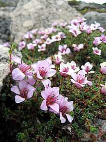
Severnaya Zemlya is a polar desert with sparse vegetation and permafrost at less than 50 cm. Rare vascular plants include species of Cerastium and Saxifraga. Non-vascular plants include the moss genera Detrichum, Dicranum, Pogonatum, Sanionia, Bryum, Orthothecium and Tortura, as well as the lichen genera Cetraria, Thamnolia, Cornicularia, Lecidea, Ochrolechia and Parmelia.[21]

According to a survey of prior observations by De Korte, Volkov, and Gavrilo, thirty-two bird species have been observed on Severnaya Zemlya, 17 of which are known to breed on the islands. Eight species are widespread across the archipelago: five species of colonial seabirds: little auk (Alle alle), Black-legged Kittiwake (Rissa tridactyla), black guillemot (Cepphus grylle), ivory gull (Pagophila eburnea), and glaucous gull (Larus hyperboreus); and three species of tundra bird: the snow bunting (Plectrophenax nivalis), purple sandpiper (Calidris maritima), and brent goose (Branta bernicla).[22]
The most common mammal on Severnaya Zemlya is the collared lemming (Dicrostonyx torquatus), which is present on all of the large islands and, in some places has been recorded to reach a density of 500 per km² (1,300 per sq mi) . The Arctic fox (Alopex lagopus) has been known to den on the islands, with several hundred observed in the 1980s. Other mammals occasionally observed include the wolf (Canis lupus), ermine (Mustela erminea), and Arctic hare (Lepus timidus), and reindeer (Rangifer tarandus).[22]
In culture
The discovery of Severnaya Zemlya is the subject of Veniamin Kaverin's novel, The Two Captains as well as its stage adaptation, Nord-Ost.
French synthpop outfit College released an instrumental piece entitled The Zemlya Expedition off the 2011 album Northern Council.
See also
References
- ↑ 1.0 1.1 Barr, William (1975). "Severnaya Zemlya: the last major discovery". Geographical Journal 141 (1): 59–71. doi:10.2307/1796946.
- ↑ http://www.nasa.gov/topics/earth/features/arctic-seaice-2012.html Retrieved on 27 August 2012
- ↑ Oil of Russia : www.oilru.com : "Oil of Russia" magazine. www.oilru.com. Retrieved on 19 October 2010.
- ↑ 4.0 4.1 (Rosnedvizhimost 22984b)
- ↑ 5.0 5.1 GEO_099_121.pdf. (PDF) . Retrieved on 19 October 2010.
- ↑ McCoy, John F. (ed.) (2002) Geo-Data: The World Geographical Encyclopedia Thomson-Gale
- ↑ "Октябрьской Революции Остров" Great Soviet Encyclopedia
- ↑ "Severnaya Zemlya" OceanDots.com at the Wayback Machine (archived December 23, 2010)
- ↑ Bassford, R.P. et al. (2006). "Quantifying the Mass Balance of Ice Caps on Severnaya Zemlya, Russian High Arctic. I: Climate and Mass Balance of the Vavilov Ice Cap". Arctic, Antarctic, and Alpine Research 38 (1): 1–12. doi:10.1657/1523-0430(2006)038[0001:QTMBOI]2.0.CO;2.
- ↑ Männik, Peep et al. (2002). "Silurian and Devonian strata Severnaya Zemlya and Sedov archipelagos (Russia)". Geodiversitas 24 (1): 99–122.
- ↑ 11.0 11.1 11.2 Arctic Ocean – Severnaya Zemlya at the Wayback Machine (archived December 23, 2010). Oceandots.com. Retrieved on 19 October 2010.
- ↑ Ecoshelf
- ↑ Russian Arctic – Severnaya Zemlya at the Wayback Machine (archived December 23, 2010) (which also features dramatic satellite photos of the islands of the Severnaya Zemlya group).
- ↑ Upper Silurian thelodonts from Severnaya Zemlya Archipelago (Russia) = Thélodontes du Silurien supérieur de l'Archipel de Severnaya Zemlya (Russie). Cat.inist.fr. Retrieved on 19 October 2010.
- ↑ J. Kollmann, M. Vieli, P. J. Edwards, K. Tockner and J. V. Ward (1999). "Interactions between Vegetation Development and Island Formation in the Alpine River Tagliamento". Applied Vegetation Science 2 (1): 25–36. doi:10.2307/1478878. JSTOR 1478878.
- ↑
- ↑ 17.0 17.1
- ↑ Депутаты Законодательного собрания Красноярского края против переименования островов архипелага Северная Земля – Официальные мероприятия Управления – Новости – Красноярский край – Роснедвижимость. R24.kadastr.ru (2007-05-25). Retrieved on 19 October 2010.
- ↑ TD13 DUPLICATE STATIONS LIST
- ↑ "Weather Data for Golymyanniy Meteorological Station". Weather Reports. Retrieved April 1, 2012.
- ↑ Manfred Bolter and Hiroshi Kanda (1997). "Preliminary results of botanical and microbiological investigations on Severnaya Zemlya 1995". Proc. NIPR Symp. Polar Biol. 10: 169–178.
- ↑ 22.0 22.1 Bird Observations in Severnaya Zemlya, Siberia. (PDF) . Retrieved on 19 October 2010.
External links
- Oceandots – Severnaya Zemlya at the Wayback Machine (archived December 23, 2010)
- Arctic photos of Severnaya Zemlya by Ólafur Ingólfsson
- List of islands (Russian language)
- Lorenz, H.; Männik, P.; Gee, D.; Proskurnin, V. (2007). "Geology of the Severnaya Zemlya Archipelago and the North Kara Terrane in the Russian high Arctic". International Journal of Earth Sciences 97 (3): 519. doi:10.1007/s00531-007-0182-2.
- Glacial and Environmental History of Severnaya Zemlya, Siberian High Arctic, During the Last > 130,000 years
- On renaming of the islands
| ||||||