Sessera
| Sessera | |
|---|---|
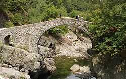
 The Sessera near Borgosesia | |
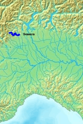 Location within Po watershed | |
| Origin | Monte Bo eastern slopes (Punta del Manzo) |
| Mouth | Sesia |
| Basin countries | Italy: province of Biella and province of Vercelli |
| Length | 35.461 km[1] |
| Source elevation | around 2000 m |
| Mouth elevation | 323[2] |
| Avg. discharge | (mouth) 7.5 m3/s[3] |
| Basin area | 189 [3] |
| Left tributaries | torrente Dolca, riale del Cavallero, torrente Strona di Postua |
| Right tributaries | torrente Ponzone |
The Sessera (Piemontese: Séssera) is a 35.5 kilometres (22.1 mi) long torrent in the Piedmont region - NW Italy.
Geography
The Sessera starts in the Biellese Alps on the south-eastern slopes of Monte Bo. It initially flows from NW to SE and then encircles the Cima dell'Asnas and forms the artificial lake of Mischie, where it meets its first important tributary, the torrente Dolca (Dolca creek).
With several meanders the Sessera reaches Coggiola and the inhabited part of its valley. After having received two other relevant tributaries, the Ponzone in Pray from right and the Strona di Postua in Crevacuore from left, it enters into the Valsesia and flows into the river Sesia near Borgosesia.[2]
Floods
The river caused severe destruction in 1968 along the Sessera Valley.[4]
See also
- Valle Sessera
- Alpi Biellesi
References
- ↑ Data base of Autorità di bacino del fiume Po (River Po Authority), on-line at: www.adbpo.it (accessed on January 2013)
- ↑ 2.0 2.1 Carta Tecnica Regionale raster 1:10.000 (vers.3.0) of Regione Piemonte - 2007
- ↑ 3.0 3.1 Piano di tutela delle acque (AI 16 - Alto Sesia). Regione Piemonte - Direzione Pianificazione delle Risorse Idriche. 2007. Retrieved 2013-01-02.
- ↑ Biellese: la catastrofica alluvione del novembre 1968, Angelo Giovi, article on Meteo giornale (on-line version in .pdf son www.meteogiornale.it)(Retrieved 2013-01-02)
Other projects
![]() Media related to Sessera at Wikimedia Commons
Media related to Sessera at Wikimedia Commons