Serra de la Mussara
| Serra de la Mussara | |
|---|---|
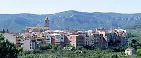 L'Aleixar with the la Mussara Mountains in the background | |
| Elevation | 1,055.6 m (3,463 ft) |
| Location | |
 Serra de la Mussara Catalonia, Spain | |
| Location | Baix Camp, Catalonia |
| Range | Prades Mountains |
| Coordinates | 41°15′28.73″N 01°03′20.80″E / 41.2579806°N 1.0557778°ECoordinates: 41°15′28.73″N 01°03′20.80″E / 41.2579806°N 1.0557778°E |
| Geology | |
| Type | Limestone |
| Climbing | |
| First ascent | Unknown |
| Easiest route | From Vilaplana |
Serra de la Mussara is a mountain range of Catalonia, Spain. It is a subrange of the Prades Mountains. Located north of the town of Vilaplana, Its highest point La Mussara has an elevation of 1,055 metres above sea level; other important peaks are Punta del Sec (979 m), Tossal Rodó (966 m) and La Puntota (858 m) and [1]
There are very steep cliffs in this range, like the Cingle del Patxeco. The Serra de la Mussara mountain range is named after the abandoned village of La Mussara, located in the range.
See also
- Prades Mountains
- Mountains of Catalonia
References
- ↑ "Mapa Topogràfic de Catalunya". Institut Cartogràfic de Catalunya. Retrieved May 22, 2010..