Serra de Monchique
| Monchique Range | |
|---|---|
| Serra de Monchique | |
|
View of the Serra de Monchique | |
| Highest point | |
| Peak | Fóia |
| Elevation | 902 m (2,959 ft) |
| Coordinates | 37°19′N 8°36′W / 37.317°N 8.600°W |
| Dimensions | |
| Length | 32 km (20 mi) NE/SW |
| Width | 7 km (4.3 mi) NW/SE |
| Geography | |
|
<div style="padding:2px 2px 2px 2px;>  | |
| Country | Portugal |
| State/Province | Algarve |
| Range coordinates | 37°19′N 8°36′W / 37.32°N 8.6°WCoordinates: 37°19′N 8°36′W / 37.32°N 8.6°W |
| Geology | |
| Orogeny | Alpine |
| Period | Late Cretaceous |
| Type of rock | Syenite, slate |
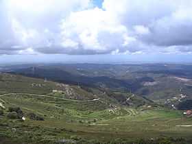
The Serra de Monchique (Monchique Range) is a chain of mountains in the western part of the Algarve region of Portugal, about 20 km inshore. The chain's highest point is the peak of Fóia, at 902 m. 774 m high Picota is another notable peak.
Description
The Monchique Range is the southwesternmost mountain range of the Iberian Peninsula. It is covered in forest and parts of the range have been transformed into eucalyptus, pine and acacia plantations which are detrimental to the native forest cover.[1] The range is named after the town of Monchique, located in the area.[2] Caldas de Monchique is a well-known spa town with geothermal springs also located in this range.
Rivers Seixe, Aljezur and Odiáxere have their sources in this range.
Geology
Geologically the Monchique Range is part of the Late Cretaceous Iberian Alkaline Igneous Province and is related to the Mount Ormonde seamount in the Gorringe Bank.[3]
See also
References
External links
 Media related to Serra de Monchique at Wikimedia Commons
- Around Monchique and the mountains