Serra d'En Galceran
| Serra d'En Galceran | |
|---|---|
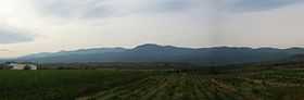 The Serra d'En Galceran range seen from Les Coves de Vinromà | |
| Elevation | 1,078 m (3,537 ft) |
| Location | |
 Serra d'En Galceran Spain | |
| Location | Plana Alta, Alcalatén, Valencian Community |
| Range | Iberian System, eastern end |
| Coordinates | 40°16′57″N 0°00′22″W / 40.28250°N 0.00611°WCoordinates: 40°16′57″N 0°00′22″W / 40.28250°N 0.00611°W |
| Geology | |
| Type | Limestone |
| Climbing | |
| First ascent | Unknown |
| Easiest route | From La Serra d'en Galceran or Albocàsser |
Serra d'En Galceran (Valencian pronunciation: [ˈsɛra ðeŋ ɡaɫseˈɾan], Spanish: Sierra de Engarcerán[1]) is a mountain range of the Valencian Community, Spain.
Geography
The main peaks of the range are the 1,078 m high Tossal de la Vila, Penya Blanca (951 m) and Tossal de la Toiola (939 m). This range is one of the most important areas in Europe where there are still pristine woods and thickets of Phoenician juniper, sometimes mixed with Kermes oak.[2] The Spanish Ibex is abundant in the range.
The towns of La Serra d'en Galceran and La Sarratella are located within the mountain range, the former one giving it its name. Parts of this mountain range fall also within the Albocàsser, Les Coves de Vinromà, la Torre d'en Doménec, Vilanova d'Alcolea, Bell-lloc and La Vall d'Alba municipal terms.
See also
- Mountains of the Valencian Community
References
- ↑ Vicenç M. Rosselló i Verger, Toponímia, geografia i cartografia
- ↑ Threat to the environment of SCI Serra d'En Galceran (ES5223055)
External links
 Media related to Serra d'En Galceran at Wikimedia Commons
- Sarratella Town Hall
| ||||||||||||||||||||||