Sentinel-2
 | |||
| Manufacturer |
| ||
|---|---|---|---|
| Operator | European Space Agency | ||
| Applications | Land observation, mapping, disaster relief support, climate monitoring | ||
| Specifications | |||
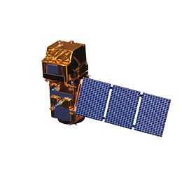
| Spacecraft type | Satellite | ||
| Constellation | 2 | ||
| Design life | 7.25 years | ||
| Launch mass | 1,200 kg (2,600 lb)[2] | ||
| Dimensions | 3.4 × 1.8 × 2.35 m (11 × 5.9 × 7.7 ft) | ||
| Power | 1.7 kilowatts (1,700 W) | ||
| Batteries | 87 Ah | ||
| Production | |||
| Built | 1 | ||
| On order | 2 | ||
| Launched | 0 | ||
| Operational | 0 | ||
| First launch | |||
| Related spacecraft | |||
| Subsatellite of | Sentinel constellation | ||
| |||
The Copernicus Programme Sentinel-2 is an Earth observation mission developed by ESA to perform terrestrial observations in support of services such as forest monitoring, land cover changes detection, and natural disaster management.
Overview
The Sentinel-2 mission will have the following capabilities:
- Multi-spectral data with 13 bands in the visible, near infrared, and short wave infrared part of the spectrum;
- Systematic global coverage of land surfaces from 56° S to 84° N, coastal waters, and all of the Mediterranean sea;
- Revisiting every 5 days at the Equator under the same viewing conditions;
- Spatial resolution of 10 m, 20 m and 60 m;
- 290 km field of view
To achieve frequent revisits and high mission availability, two identical Sentinel-2 satellites (Sentinel-2A and Sentinel-2B) are planned to operate simultaneously. The planned orbit is Sun-synchronous at 786 km altitude (14.3 revolutions per day) with a 10:30 a.m. descending node. This local time was selected as a compromise between minimizing cloud cover and ensuring suitable Sun illumination. It is close to the Landsat local time and matches SPOT’s, allowing the combination of Sentinel-2 data with historical images to build long-term time series. The two satellites will work on opposite sides of the orbit. The launch of the first satellite is expected on 12 June 2015 on a Vega launch vehicle.[3]
Instruments
The Sentinel-2 satellites will each carry a single multi-spectral instrument (MSI) with 13 spectral channels in the visible/near infrared (VNIR) and short wave infrared spectral range (SWIR).
Applications
- Risk management (floods, forest fires, subsidence, and landslides)
- European land use/land cover state and changes
- Forest monitoring
- Food security/early warning systems
- Water management and soil protection
- Urban mapping
- Natural hazards
- Terrestrial mapping for humanitarian aid and development
Training data sets
In June 2013, the Centre National d'Etudes Spatiales (CNES) released and distributed training data sets acquired by the SPOT 4 satellite with the same repetitivity as planned for Sentinel-2, to help future Sentinel-2 users develop methods and applications based on multitemporal data. This experiment, named SPOT4 (Take5), was held between February and June 2013, and provided time series over 45 sites for a variety of applications. To obtain this data set, the orbital altitude of SPOT4 was decreased by 2 kilometres (1.2 mi) in order to place it in a 5-day revisit cycle.[5]
This experiment is being repeated with the SPOT 5 satellite, thanks to a co-funding from ESA and CNES, between April and September 2015. This time 150 sites will be observed. The first data will be freely available to users from the end of June.
References
- ↑ "Sentinel 2 - Earth Online - ESA". ESA. Retrieved 17 August 2014.
- ↑ "Sentinel-2" (PDF). European Space Agency. ESA. 2013. Retrieved 2015-02-26.
- ↑ 3.0 3.1 Amos, Jonathan (26 February 2015). "Sentinel-2: Europe's 'Landsat' ready to picture Planet Earth". BBC News (London). Retrieved 2015-02-26.
- ↑ "Bringing Sentinel-2 into focus". ESA. Retrieved 17 August 2014.
- ↑ Hagolle, Olivier (28 November 2014). "Slides from the second SPOT (Take 5) Workshop". Séries Temporelles. Paul Sabatier University. Retrieved 23 April 2015.
External links
- Sentinel-2 at ESA
- Copernicus at ESA
- Sentinel-2 mission requirements document
- Sentinel-2 data sheet
- SPOT 4 (Take 5)
| ||||||||||||||||||||||||||||||||

| ||||||||||||||||||||||||||||||||||||||||||||||||||||||||||||||||||||||||||||||||