Selz
| Selz | |
|---|---|
 | |
| Origin | Donnersbergkreis |
| Mouth |
Rhine at Ingelheim 49°59′45″N 8°1′33″E / 49.99583°N 8.02583°ECoordinates: 49°59′45″N 8°1′33″E / 49.99583°N 8.02583°E |
| Basin countries | Germany |
| Length | 63 km (39 mi) |
| Source elevation | 321 m (1,053 ft) |
| Avg. discharge | 0.77 m3/s (27 cu ft/s) |
| Basin area | 375 km2 (145 sq mi) |
The Selz is a river in Rhineland-Palatinate, Germany, a left tributary to the Rhine. It flows through the biggest German wine region, which is called Rheinhessen.
It rises near the village Orbis in the Donnersbergkreis, passes the border from the Palatinate to Rheinhessen and after about 8 kilometres (5 mi) the city of Alzey in the Alzey-Worms district. There the river passes a pond, and vanishes underground, flowing through the canalisation of the town. On their way she crosses Gau-Odernheim, Nieder-Olm and Ingelheim, finally discharging in Frei-Weinheim into the Rhine.
Its 375 square kilometres (145 sq mi) comprising watershed is determined by warm dry climate showing an average yearly precipitation around 500 millimetres (20 in). Despite its slender, in many cases irregular water flow conditions, the Selz is regarded as receiving stream of the low rainfall area of the rheinhessian rolling country. During low water periods the discharge consists to a notable amount out of clean effluents of wastewater treating plants.
Environmental restoration
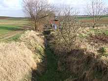
Some decades of the 20th century were characterized by river straightening throughout the rivers and creeks in Germany. Due to this river training in the years between 1958–1963, the Selz creek is constricted between embankments and flows relative meandering through the plain, between the famous rolling hills of Rheinhessen. In order to stop river bed degradation and to improve both, biodiversity and flood protection, the local nature conservation foundation (Selztalverband) and the district Mainz-Bingen managed a revitalization of the Selz over a notable length between Hahnheim, Undenheim and Sörgenloch.
Loss of floodplain and shorter river reaches caused higher flood peaks and risk of flood in the past. Some floods near disaster were the reason for a restoration concept. The concept contains flood protection, river bed stabilization and renaturization measures. The main objectives are:
- flood protection for HQ100
- improvement of the ecological situation
- stabilizing river bed/erosion control
- stabilizing groundwater level
Floodplains have been increased between 50 to 100 metres (160 to 330 ft) in width. Nature is allowed to develop undisturbed in biotopes, which protect and promote the biodiversity of the landscape with its meadows, trenches, bank slopes, marsh areas, wetland, phragmites, willows, hedges and boundary ridges. During the past 25 years, the village of Hahnheim has planted 27,000 trees and hedges along the Selz in its boundary.
Since the Selz renaturation project covers several miles of the Selz River's bank, it is increasing the total length of the river.
From origin to mouth

The following villages and towns are located at the Selz:
- Orbis
- Morschheim
- Mauchenheim
- Alzey
- Alzey-Schafhausen
- Framersheim (Confluence of Weidas and Selz)
- Gau-Köngernheim
- Gau-Odernheim
- Bechtolsheim
- Undenheim
- Friesenheim
- Köngernheim
- Selzen
- Hahnheim
- Sörgenloch
- Nieder-Olm, the reason for the foundation of Nieder-Olm is given by the passage of an old Roman road over the Selz river which lead to the Roman camps around Mainz and the city itself.
- Stadecken-Elsheim
- Bubenheim
- Schwabenheim an der Selz
- Groß-Winternheim
- Ingelheim am Rhein
Cycle track

A signposted cycle track along the Selz creek, the Selztalradweg, uses partially two old railway tracks of the Amiche and Zuckerlottche. Both railway tracks have an asphalt surface. Sometimes a cycle path directly along the water bed may be used, as long as the weather is dry. Both ways proceed in parts under high trees, sheltering from the hot sun.
External links
| Wikimedia Commons has media related to Selz (River). |
- restoring Selz River
- pathways along the Selz PDF (3.37 MB)
| ||||||||||||