Selayar Islands Regency
| Selayar Islands Regency Kepulauan Selayar | ||
|---|---|---|
| Regency | ||
 | ||
| ||
| Nickname(s): Tanadoang | ||
| Motto: Selayar Mapan Mandiri | ||
 Selayar Islands Regency Location of Selayar Islands Regency in Indonesia | ||
| Coordinates: 6°32′S 121°15′E / 6.54°S 121.25°E | ||
| Country | Indonesia | |
| Province | South Sulawesi | |
| Anniversary | 29 November 1605 | |
| Government | ||
| • Regent | Drs. H. Syahrir Wahab, MM | |
| • Vice-regent | H. Saiful Arief, SH | |
| Area | ||
| • Total | 10,503.69 km2 (4,055.50 sq mi) | |
| Population (2010) | ||
| • Total | 121,905 | |
| • Density | 12/km2 (30/sq mi) | |
| Time zone | WITA (UTC+8) | |
| Pos code | 92812 | |
| Area code(s) | (+62) 414 | |
| Vehicle registration | DD | |
| Website |
selayaronline | |
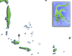
The Selayar Islands Regency is a regency of Indonesia in South Sulawesi province that covers the Selayar Islands, which lie to the south of Sulawesi. The Selayar Straits separate the regency from Sulawesi island.
Administration
Districts
The Selayar Islands Regency is divided into eleven districts (kecamatan), tabulated below with their 2010 Census populations[1] and their administrative centres ('capitals').
| Name | Population Census 2010 | Capital |
|---|---|---|
| Pasimarannu | 8,959 | Bonerate |
| Pasilambena | 6,786 | Kalaotoa |
| Pasimassunggu | 7,625 | Kembang Ragi |
| Takabonerate | 12,296 | Batang |
| Pasimassunggu Timur (East Pasimassunggu) | 7,307 | Bontobulaeng |
| Bontosikuyu | 14,332 | Harapan |
| Bontoharu | 12,484 | Bontobangun |
| Benteng | 21,344 | Benteng |
| Bontomanai | 12,226 | Polebungin |
| Bontomatene | 12,571 | Batangmata |
| Buki | 6,125 | Buki |
Regent
Here are the names of the Leader / Regent Selayar Islands since 1739 until now :
| colspan="5" font-size:100%" style="background-color:AliceBlue;" |Colonization Period VOC | ||||
|---|---|---|---|---|
| No | Name | Designation / Position | year of Assignment | Handover Years |
| 1 | W. Coutsier | Resident | 1739 | 1743 |
| 2 | Bargraf | Resident | 1743 | 1753 |
| 3 | D. J. Tempesel | Resident | 1753 | 1757 |
| 4 | A. Revenabers | Resident | 1757 | 1757 |
| 5 | J. C. Helmkamp | Resident | 1757 | 1757 |
| 6 | H. Burggraff | Resident | 1757 | 1758 |
| 7 | J. B. Bekker | Resident | 1758 | 1764 |
| 8 | M. van Rossen | Resident | 1764 | 1766 |
| 9 | J. H. Voll | Resident | 1766 | 1780 |
| 10 | L. J. Swart | Resident | 1780 | 1781 |
| 11 | Awetys | Resident | 1781 | 1789 |
| data sources : www.selayaronline.com | ||||
| colspan="5" font-size:100%" style="background-color:AliceBlue;" |Colonization Period Hindia-Belanda | ||||
|---|---|---|---|---|
| No | Name | Designation / Position | year of Assignment | Handover Years |
| 12 | S. Jassen | Resident | 1789 | 1801 |
| 13 | H. C. H. Anrhe | Resident | 1801 | 1806 |
| 14 | S. Jassen | Resident | 1806 | 1807 |
| 15 | H. C. Rosebon | Resident | 1807 | 1820 |
| 16 | G, W. Muller | Resident | 1820 | 1824 |
| 17 | J. C. B. Baren | Asisten Resident | 1824 | 1825 |
| 18 | Bakman Klerk | W. D. Resident | 1825 | 1827 |
| 19 | J. C. Rad N. Barge | W. D. Resident | 1827 | 1830 |
| 20 | H. Mulder | W. D. Resident | 1830 | 1839 |
| 21 | J. L. Mulder | Gesag Herbber | 1839 | 1843 |
| 22 | Trompburg | Gesag Herbber | 1843 | 1848 |
| 23 | P. H. van Heyest | Gesag Herbber | 1848 | 1851 |
| 24 | J. AJ. Voll | Gesag Herbber | 1851 | 1855 |
| 25 | W. Delancy | Gesag Herbber | 1855 | 1857 |
| 26 | G. A. van Kesteran | Gesag Herbber | 1857 | 1857 |
| 27 | A. H. Swaring | W. D. Controleuer | 1857 | 1859 |
| 28 | J. W. Kroller | Gesag Herbber | 1859 | 1860 |
| 29 | G. A. van Kerteran | Ambel Mibesteur | 1860 | 1863 |
| 30 | W. DE. Lancy | Controleur 2 EKL | 1863 | 1865 |
| 31 | A. L. H. A. Negel | Controleur 2 EKL | 1865 | 1867 |
| 32 | W. F. Sikman | Controleur 2 EKL | 1867 | 1870 |
| 33 | A. C. F. Burlet | Controleur 2 EKL | 1870 | 1873 |
| 34 | J. F. Schenk Muisen | Controleur 1 EKL | 1873 | 1873 |
| 35 | D. F. vanbram Morris | Controleur Vanmei | 1873 | 1876 |
| 36 | H. C. Begeardt | Controleur Vanmei | 1876 | 1877 |
| 37 | G. A. L. W. Sol | Controleur 2 EKL | 1877 | 1878 |
| 38 | P. D. Wiggers | Controleur 2 EKL | 1878 | 1878 |
| 39 | R. H. D. Fongelbert | Controleur 1 EKL | 1878 | 1881 |
| 40 | A. J. Baren Quarles | Controleur 1 EKL | 1881 | 1882 |
| 41 | A. A. Schuuten | Controleur 2 EKL | 1882 | 1884 |
| 42 | W. G. Coenen | Asp. Controleur | 1884 | 1885 |
| 43 | J. C. E. T Rom | Controleur 1 EKL | 18 December 1885 | 18 May 1887 |
| 44 | E. A. Klerk | Controleur 1 EKL | 18 May 1887 | 17 July 1888 |
| 45 | Th Krusen | Controleur 1 EKL | 17 July 1888 | 17 June 1889 |
| 46 | J. van Hassteri | Controleur 2 EKL | 17 June 1889 | 16 October 1889 |
| 47 | F. Wiggers | Controleur 2 EKL | 16 October 1889 | April 1894 |
| 48 | D. C. Boek | Controleur 1 EKL | April 1894 | April 1895 |
| 49 | G. J. Kopman | Controleur 2 EKL | April 1895 | 7 January 1899 |
| 50 | H. J. Kregers | Controleur 2 EKL | 7 January 1899 | 9 August 1901 |
| 51 | B. G. A. J van Binter | Controleur 2 EKL | 18 October 1901 | 13 January 1903 |
| 52 | H. H. Lubliek Weddik | Asp. Controleur | 9 May 1903 | 13 November 1903 |
| 53 | O. M. Goedhart | Controleur | 13 November 1903 | 11 February 1904 |
| 54 | P. A. Qudemans | Controleur | 13 June 1904 | 18 August 1905 |
| 55 | H. R. Adesma | Asp. Controleur | 18 August 1905 | 6 March 1906 |
| 56 | L. R. Wenthold | Asp. Controleur | 8 March 1906 | 21 June 1907 |
| 57 | J. J. Lena | Asp. Controleur | 21 June 1907 | 29 June 1910 |
| 58 | G. L. Barents | Asp. Controleur | 29 June 1910 | 6 July 1912 |
| 59 | R. A. W. Schrouder | Asp. Controleur | 6 July 1912 | 29 August 1912 |
| 60 | E. E. W. C. Sehrekreden | Asp. Controleur | 29 August 1912 | 2 February 1914 |
| 61 | D. J. C. Kreeber | Asp. Controleur | 2 February 1914 | 2 June 1916 |
| 62 | B. J. M. Baden | Gesaghebber | 2 June 1916 | 26 January 1919 |
| 63 | C. M. Buys | Controleur | 27 January 1919 | 6 January 1920 |
| 64 | J. T. Misandolle | Controleur | 6 January 1920 | 1 June 1920 |
| 65 | A. M. Ballot | Controleur | 1 June 1920 | 13 December 1920 |
| 66 | H. T. Lanting | WD. Controleur | 13 December 1920 | 28 April 1921 |
| 67 | H. C. Groenestein | Gesaghebber | 28 April 1921 | 5 May 1922 |
| 68 | W. D. J. van Andel | FD. Controleur | 5 May 1922 | 21 January 1925 |
| 69 | S. L. E. van Woendenburg | Controleur | 21 January 1925 | 10 July 1925 |
| 70 | C. F. Schoeder | Gedepl Gesaghebber | 10 July 1925 | 20 July 1925 |
| 71 | F. B. R. van Resum | Asp. Controleur | 20 July 1925 | 18 August 1925 |
| 72 | J. H. W. van Den Missen | Asp. Residen Titulair | 18 August 1925 | 16 December 1925 |
| 73 | H. J. Woest Hoer | Controleur | 16 December 1925 | 16 May 1926 |
| 74 | S. Stuensma | Controleur | 16 May 1926 | 20 April 1927 |
| 75 | J. B. M. Delion | Controleur 1 EKL | 20 April 1927 | 7 July 1928 |
| 76 | H. J. Hoeetra | Controleuriekl B.B | 7 July 1928 | 26 January 1929 |
| 77 | J. Koester | Controleuriekl B.B | 26 January 1929 | 23 December 1929 |
| 78 | D. J. A. Vander Vliot | Gesaghebber 1 EKL | 23 December 1929 | 17 October 1932 |
| 79 | A. Twerde | Controleuriekl B.B | 17 October 1932 | 17 January 1933 |
| 80 | J. W. D. Monti | Gedip Gesaghebber | 17 January 1933 | 18 February 1936 |
| 81 | Dr. OH. Noetebom | Controleur | 18 February 1936 | 11 October 1937 |
| 82 | J. M. van Liye | Controleur | 11 October 1937 | 22 February 1939 |
| 83 | G. J. Wolf Hoff | Controleur | 22 February 1939 | 21 July 1939 |
| 84 | J. A. Willeman | WD. Controleur | 21 July 1939 | 25 July 1939 |
| 85 | J. M. van Keekeh | FD. Controleur | 25 July 1939 | 28 August 1940 |
| 86 | W. Klaus | Gedip Gesaghebber | 28 August 1940 | 1 November 1941 |
| 87 | W. Heeybeer | Controleur | 1 November 1941 | 29 April 1942 |
| data sources : www.selayaronline.com | ||||
| colspan="5" font-size:100%" style="background-color:AliceBlue;" |Colonization Period Jepang | ||||
|---|---|---|---|---|
| No | Name | Designation / Position | year of Assignment | Handover Years |
| 88 | M. Opoe Patta Boendoe | Guntjo Sodai | 29 April 1942 | 21 June 1943 |
| 89 | Momono | Bunken Kanriken | 21 June 1943 | 13 May 1944 |
| 90 | T. Misouti | Bunken Kanriken | 13 May 1944 | 14 September 1945 |
| 91 | M. Opoe Patta Boendoe | Bunken Kanriken | 14 September 1945 | 11 February 1946 |
| data sources : www.selayaronline.com | ||||
| colspan="5" font-size:100%" style="background-color:AliceBlue;" |Colonization Period NICA | ||||
|---|---|---|---|---|
| No | Name | Designation / Position | year of Assignment | Handover Years |
| 92 | W.H. Ayboer | Controleur | 11 February 1946 | 9 March 1946 |
| 93 | T. J. Halvedrusse | Controleur | 9 March 1946 | 5 February 1947 |
| 94 | J. van Bodegong | Controleur | 5 February 1947 | 21 June 1947 |
| 95 | C. H. Mollen | Controleur | 21 June 1947 | 30 August 1947 |
| data sources : www.selayaronline.com | ||||
| colspan="5" font-size:100%" style="background-color:AliceBlue;" |Period States Government of the Republic of Indonesia | ||||
|---|---|---|---|---|
| No | Name | Designation / Position | year of Assignment | Handover Years |
| 96 | Muh. Ali Krg. Bonto | Bertuurshoofd | 30 August 1947 | 3 April 1950 |
| 97 | Andi Achmad | Bertuurshoofd | 3 April 1950 | 15 June 1950 |
| 98 | Tadjuddin Dg. Matjora | vice KPN | 15 June 1950 | 29 June 1950 |
| 99 | Aroeppala | Bertuurshoofd | 29 June 1950 | 20 October 1951 |
| data sources : www.selayaronline.com | ||||
| colspan="5" font-size:100%" style="background-color:AliceBlue;" |Period of Government of the Republic of Indonesia | ||||
|---|---|---|---|---|
| No | Name | Designation / Position | year of Assignment | Handover Years |
| 100 | Abd. Karim | vice KPN | 20 October 1951 | 5 May 1952 |
| 101 | Muh. Arsyad | KPN | 5 May 1952 | 11 June 1953 |
| 102 | Abd. Karim | vice KPN | 11 June 1953 | 14 August 1953 |
| 103 | Djamaluddin | KPN | 14 August 1953 | 18 July 1955 |
| 104 | Bustam Dg. Sitaba | KPN | 18 July 1955 | 1 December 1956 |
| 105 | Marcus Pong Manda | KPN | 1 December 1956 | 4 March 1960 |
| 106 | Andi Matja Amirullah | Regent | 4 March 1960 | 10 April 1965 |
| 107 | Drs. Patta Tjora | Pds. Regent | 10 April 1965 | 5 August 1965 |
| 108 | Drs. A. H. Dg. Marimba | Regent | 5 August 1965 | 6 November 1968 |
| 109 | M. Amin Dg. Suroresiden | Pel. Tgs. Regent | 6 November 1968 | 1 May 1969 |
| 110 | Abd. Rauf Rahman | Regent | 1 May 1969 | 25 January 1971 |
| 111 | A. Palioi | Regent | 25 January 1971 | 18 November 1974 |
| 112 | H. Andi Bachtiar | Pd. Regent | 18 November 1974 | 14 September 1975 |
| 113 | Drs. Anas Achmad | Regent | 14 September 1975 | 16 December 1983 |
| 114 | Drs. H. A. Achmad Natsir | Pel. Tgs. Regent | 16 December 1983 | 10 July 1984 |
| 115 | Ismail | Regent | 10 July 1984 | 10 July 1989 |
| 116 | Drs. Z. Arifin Kammi | Regent | 10 July 1989 | 11 July 1994 |
| 117 | Drs. H. M. Akib Patta | Regent | 11 July 1994 | 11 August 1999 |
| 118 | H. Mirdin Kasim, SH, M.Si | Pj. Regent | 11 August 1999 | 29 December 1999 |
| 119 | Drs. H. M. Akib Patta | Regent | 29 December 1999 | 29 December 2004 |
| 120 | H. A. Syamsul Alam Mallarangeng | Pj. Regent | 29 December 2004 | 30 October 2005 |
| 121 | Drs. H. Syahrir Wahab, MM | Regent | 30 October 2005 | to date |
| data sources : www.selayaronline.com | ||||
Demography
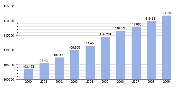
| Population growth charts Selayar Islands Regency |
|---|
 |
| |
Sea turtle village
Kampung Penyu (Sea turtle village) in Bontomanai district is sea turtle conservation area under supervision of Taka Bone Rate National Park.[2]
Old pictures
References
- ↑ Biro Pusat Statistik, Jakarta, 2011.
- ↑ Fadly Syarif. "Kampung Penyu dalam kemeriahan Takabonerate Island Expedition 2013". Retrieved June 7, 2014.
External links
- (Indonesian) http://selayar.org
- (Indonesian) http://www.bappeda.selayaronline.com
- (Indonesian) http://www.pariwisataselayar.com
- (Indonesian) http://www.sulsel.go.id/content/kab-selayar
- (Indonesian) http://regionalinvestment.com/newsipid/area.php?ia=7301
- (Indonesian) Wikisource/Selayar Regency into Selayar Islands Regency
- (Indonesian) Wikisource/Penduduk & ketenagakerjaan selayar tahun 2010
- (Indonesian) Wikisource/Pariwisata selayar tahun 2010
- (English) http://lombokcruises.com/indonesia-islands-destination/selayar-island
- (English) http://www.selayar-dive-resort.com
- (English) http://www.selayarislandresort.com
| |||||||||||||
| ||||||||||||||||||||||
